Communication

Assessing Fire Regimes in the Paraguayan Chaco: Implications for Ecological and Fire Management

by
Cristina Vidal-Riveros
1,*,
William Jefferson Watler Reyes
2,
Marie Ange Ngo Bieng
3 and
Pablo Souza-Alonso
1
1
Escuela Politécnica Superior, Department of Soil Science and Agricultural Chemistry, University of Santiago de Compostela, 27002 Lugo, Spain
2
Watersheds, Water Security and Soils Unit, Tropical Agricultural Research and Higher Education Center (CATIE), Turrialba 30501, Costa Rica
3
Forêts et Sociétés Research Unit, Center for International Cooperation in Agricultural Research (CIRAD), 34398 Montpellier, France
*
Author to whom correspondence should be addressed.
Fire 2024, 7(10), 347; https://doi.org/10.3390/fire7100347
Submission received: 23 July 2024 / Revised: 12 September 2024 / Accepted: 25 September 2024 / Published: 29 September 2024
(This article belongs to the Special Issue Fire in Savanna Landscapes, Volume II)

Abstract

:
This study analyzed the fire regime in the highly diverse Paraguayan Chaco, focusing on different aspects of fire patterns, including spatial (area burned) and temporal (frequency) aspects and magnitude (severity). We focused on fire as it is a natural phenomenon that drives ecosystem change and has significant economic, ecological and social impacts of particular concern in vulnerable ecosystems. Using the K-means clustering technique, we identified four distinct fire regimes in the study region: High (H), Moderately High (MH), Moderately Low (ML) and Low (L). On the one hand, the Dry Chaco predominantly featured Low and Moderately High regimes, characterized by a low fire frequency due to arid conditions. On the other hand, the Humid Chaco was particularly affected by agricultural burning, driven by extensive livestock activity and higher biomass productivity. Finally, in the Pantanal, the variations in fire intensity were influenced by flood pulses and rainfall patterns. Our findings highlight the distinct fire regimes across the Paraguayan Chaco and detail the differences in the regimes. The study’s findings are valuable for developing efficient management strategies that account for fire behaviour during agricultural burning in this poorly studied region.

1. Introduction

Fire is a natural phenomenon in flammable landscapes, acting as a significant driver of ecological change with economic, ecological and social impacts [1]. These impacts are determined by the fire’s behaviour within a specific time and space, known as the fire regime [2]. Fire regimes can generally be defined by spatial and temporal attributes and their magnitude, which collectively describe the role of fire in different ecosystems [3].
Spatial attributes are represented by the size of the burnt area and also include information regarding fire location [4]. Temporal attributes are represented by the seasonal distribution or fire frequency, i.e., the number of fires that occurred in a given period [5]. Variations in these attributes include the fire return interval, which is the time between fires at a specific point, expressed as a mean, median, minimum or maximum [3]. Fire frequency generally represents the temporal dimension in fire regime studies, but variations depend on the study objectives. For instance, the fire return interval is more informative for studying ecosystem degradation or resilience. Finally, fire magnitude is generally represented by fire intensity or fire severity, which represent distinct aspects of fire, although they are sometimes used interchangeably in non-specific studies. Fire severity is defined as the impact of fire on the ecosystem [6]. It is generally defined by burn indices such as the normalized burn ratio (NBR), differences in the NBR (dNBR) and relative differences in the NBR (RdNBR), using datasets to capture a wide range of fire conditions and characterize landscape-to-regional-scale fire severity [7,8,9]. However, severity can also be assessed in the field by using observational data such as species composition and structure [10], seasonality [11] and the fire weather index [12].
Fire regime studies are common at global and continental scales [13]. For example, European pyroregions have been defined on the basis of burnt area, fire frequency, climate and fire seasonality [14]. In other cases, burnt area, number of fires and land cover types have been used to describe fire patterns [15]. In the mountainous regions of the US, fire regimes are characterized by severity and frequency [16], whereas in Australia, fire regimes have been shaped based on frequency and intensity [17].
In South America, several recent studies have expanded the understanding of fire regimes through diverse data sources and methodologies. For example, in Chile, the spatial and temporal dynamics of fires have been described using the national wildfire database provided by the Chilean Forest Service (CONAF) combined with monthly burned area (MODIS) data [18]. In Brazil, fire frequency and return intervals were analyzed over a 12-year period in a protected area of the Cerrado [19]. The drivers and effects of fire were assessed in the Argentinean Chaco, clearly highlighting differences between the Humid and the Dry Chaco, as well as revealing significant variations in fire behaviour and the impacts in different countries [20].
Despite the wealth of literature on fire regimes in fire-prone regions of South America, significant knowledge gaps remain, particularly in areas such as the Gran Chaco Americano in some of its regions, such as the Paraguayan Chaco, the most unexplored region within the Gran Chaco in terms of fire behaviour [21]. During the period 1999–2015, Paraguay had the fourth largest number of wildfires in South America, even surpassing Brazil in terms of the average number of fire outbreaks, thus indicating the very high incidence of fires in the country [22]. This issue highlights the urgent need for fire regime studies to understand impacts, propose management actions and preserve land. This study aimed to model the fire regime in the Paraguayan Chaco, considering spatial (area burnt) and temporal (frequency) attributes and magnitude (severity).

2. Materials and Methods

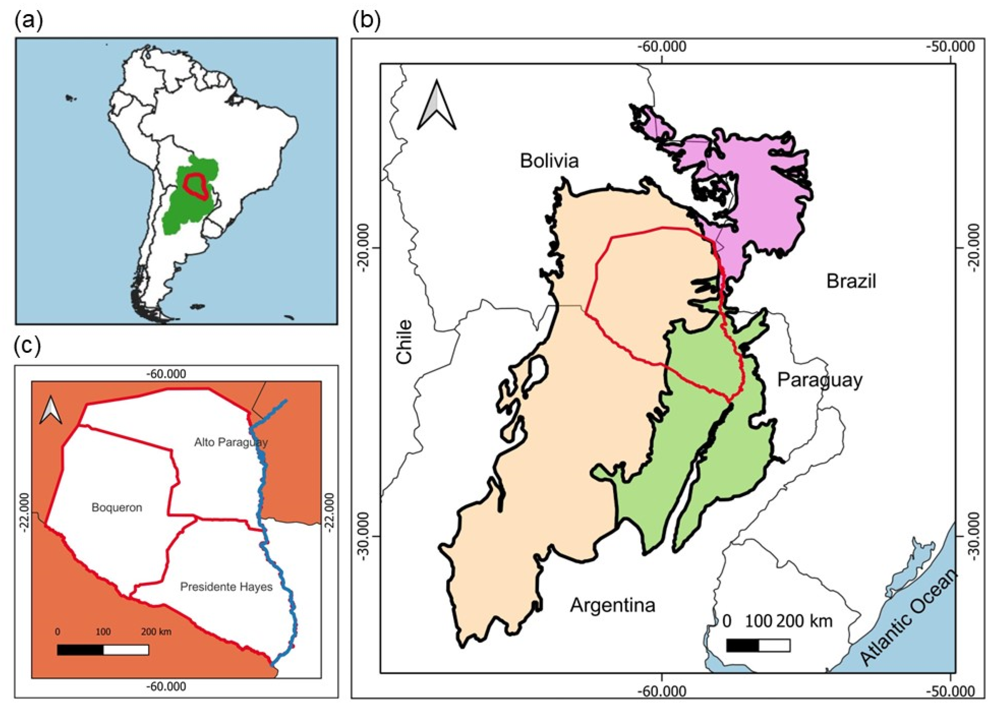
2.1. Description of Study Area

The study area encompasses three ecoregions in the South American continent (Figure 1a): the Dry Chaco, the Humid Chaco and the Pantanal, collectively known as the Gran Chaco Americano, which spans an area of 1,141,000 km2 (Figure 1b). These ecoregions are shared by four countries: Argentina (60%), Paraguay (27%), Bolivia (11%) and Brazil (2%) [23].
Climatically, the Chaco region experiences a pronounced dry season (May to September) with average monthly temperatures reaching 29 °C. The rainfall gradient varies between 1200 mm in the east to 450 mm in the centre, resulting in highly heterogeneous vegetation. The eastern Chaco, the wettest part, comprises extensive wetlands and is mainly dominated by wet savannas, comprising a mosaic of dense or open woodland patches interspersed with grasslands [24].
The Paraguayan Chaco (Figure 1c) represents a large portion of the Gran Chaco, covering an area of 230,000 km2 and including the departments of Boquerón, Alto Paraguay and Presidente Hayes [25]. It is located to the west of the Paraguay river, which serves as a natural border dividing the country into two distinct regions. The climate is semi-arid, with an average rainfall of 400 mm. Rainfall distribution is uneven, with the north and northwest receiving between 400 and 800 mm/year, mostly during spring and summer. By contrast, the northeast, east and southeast, closer to the Paraguay River, receive 1300–1400 mm of rainfall a year, with more regular distribution. Consequently, there is a pronounced east–west gradient in precipitation and humidity, with increasing aridity towards the west, culminating in the driest areas near the Andean foothills [26]. Winters are extremely dry, with rainfall in July–August not exceeding 34 mm/year. Average temperatures range between 13 and 34 °C, with summer peaks of 45–48 °C and winter lows of −3 to −7 °C [27].
The vegetation distribution is influenced by climate, with denser woodlands occurring in areas receiving precipitation of 800–1300 mm/year, and shrublands of varying densities found in regions receiving less than 800 mm/year. The primary socioeconomic activities are cattle ranching and soybean and dairy production. In the past decade, these industries (especially cattle ranching) have expanded greatly and have become major drivers of deforestation in the country [28]. Consequently, the forest ecosystems are highly fragmented and degraded. Fire is an essential tool for agricultural practises, such as renewing pastures for cattle and clearing fields for various activities. Furthermore, these ecoregions are prone to fire, as indicated by other studies in the same areas [29,30,31].

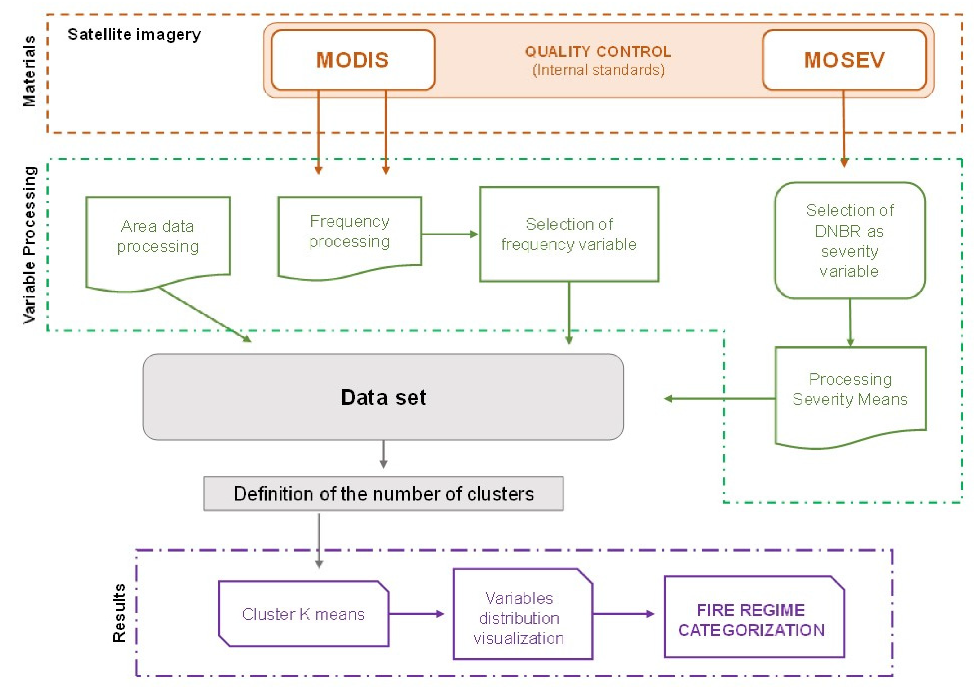
2.2. Data Collection and Remote Sensing Products

The pyroregions were defined on the basis of the selection of the most important variables after an extensive literature review of fire regime attributes. Thus, fire frequency, burn severity and burnt area were selected as fire variables. Two different satellite products, the MODIS MCD64A1 (Version 6) Burned Area database and the MOSEV database were then selected according to their time spans and temporal scale resolutions. MODIS MCD64A1 is a product that provides monthly per-pixel burned area and quality information on a 500 m global grid that uses 500 m MODIS Surface Reflectance imagery coupled with 1 km MODIS active fire observations [32]. MCD64A1 was selected due to its temporal resolution (1–2 days) to detect fire spots and because it has recently been used in South American ecosystems for different purposes, e.g., post-fire restoration [33], examining fire impact on biodiversity [34] and fire mapping in Brazilian savannas [35]. The MOSEV database (derived from MODIS) includes the most commonly used indices of severity for the period from 2000 to 2020. The product relies on the combination on Terra MOD09A1 and Aqua MYD09A1 surface reflectance products to obtain dense time series of the NBR spectral index, and the MCD64A1 product was used to identify BA and the date of burning [36]. MOSEV also provides the dNBR and the RdNBR, both considered fire severity metrics that are suitable for characterizing fire impacts.
MODIS MCD64A1 was obtained from the NASA Land Processes Distributed Active Archive Center (https://lpdaac.usgs.gov, accessed on 11 November 2022) and the MOSEV database was obtained from https://zenodo.org/record/4265209#.Y3dbG3bMK3A (accessed 10 November 2022).

2.3. Data Quality Control

To ensure the reliability of the satellite data, we implemented several quality control measures. For the MODIS MCD64A1 dataset, the product’s internal quality assurance (QA) flags were used to exclude low-quality observations, such as those affected by cloud cover, atmospheric disturbances and sensor anomalies. These QA flags provide pixel-level information on the reliability of the data, enabling the identification and exclusion of pixels flagged as having low confidence in burned area detection. Only pixels that provided reliable burned area detection were included in the analysis to minimize false positives or missed detections.
For the MOSEV dataset, we validated the burn severity metrics (dNBR and RdNBR) by cross-referencing them with active fire detections from the MODIS Fire and Thermal Anomalies (MOD14A1) product, ensuring temporal alignment between the burned area and fire severity data.

2.4. Fire Regime Characterization

The fire regimes in the Gran Chaco and Pantanal were characterized using K-means clustering analysis (Figure 2), an unsupervised data mining method that groups data with similar characteristics. This technique does not require training or testing data and does not require a target output. K-means is effective in grouping fire regimes with distinct fire characteristics and is flexible enough to handle the spatial–temporal dynamics of fire patterns in the study area, where predefined classes of fire regimes do not exist. Use of this unsupervised approach enabled us to explore hidden patterns and establish well-defined fire regime clusters, enhancing our understanding of the fire dynamics in the region. Before running the cluster, we used MODIS to determine the fire frequency and area burnt. The fire frequency was calculated as the total number of times that the area represented by a pixel was burnt within a year. Additional frequency variables were also computed, including the time span between fires, minimum time span, maximum time span and 2 to 5 consecutive time spans.
We selected the total fire frequency year−1 as the primary frequency variable, to maintain consistency with the literature and to align with the data aggregation within each cluster. The total burnt area was calculated using a circular window of 7 × 7 pixels with a maximum of 49 pixels per window, also serving as a proxy for the burnt area. Severity was calculated using a function of the terra package for spatial data manipulation (R program, version 4.2.2). This enabled us to obtain the mean fire severity for the study period (2001–2020). Data were retrieved from MOSEV tiles and cropped to the local scale. We opted to use the dNBR index, which reflects the post-fire impacts on vegetation reflectance relative to the pre-fire condition [9]. The twenty-year time series was summarized in a raster file representing the severity index for the study area.
For the cluster analysis, we rescaled the variables into Z-scores with a zero mean and unit variance, as recommended in most clustering approaches. The K-means clustering approach consisted of an unsupervised learning method that iteratively partitions the dataset into a predefined number of non-overlapping clusters or subgroups [37]. The number of clusters was defined using the elbow method, which provided an estimate based on the within-cluster sum of squares (WCSS) between data points and the centroids of the assigned clusters. We chose k at the point where the WCSS curve starts to flatten and forms an elbow (SM1). We ran the K-means clustering with the three selected variables (fire frequency, fire severity and burnt area) ten times using different centroids as references until the model converged. Additionally, we performed a sensitivity analysis by running K-means clustering with different values of k = 2, 3, 5, and 10. We recalculated the WCSS for k ranging from 1 to 10 to assess the efficiency of each clustering solution. Then, we created box plots for each k to visualize the behaviour of the variables (SM2) and selected the value of k that best aligned with the ecological conditions of the study area. The thresholds for each variable within each cluster were visualized using the ggplot2 and patchwork packages in R software.

3. Results

The K-means results suggest that the appropriate number of clusters is between three and four (SM1). Based on the box plot analysis (Figure 3) and the ecological background of the study area, we identified four distinct clusters that can be attributed to four different fire regimes in the Paraguayan Chaco: High (H), Moderate High (MH), Moderate Low (ML) and Low (L) (Figure 3). The most prevalent regimes at the scale of the Paraguayan Chaco were L (45.76%) and MH (28.96%) (Figure 4), while the least represented cluster was H (5.98%). However, the dominance of each fire regime varied between the ecoregions (Dry Chaco, Humid Chaco and Pantanal).
Clusters L and MH predominated within the Dry Chaco ecoregion (Figure 4). These regimes indicate a higher frequency of fires and smaller burned areas. Fire severity, however, varied between the clusters, with MH being the most severe. This MH cluster is concentrated in the north of the Paraguayan Chaco, particularly in the Alto Paraguay department, and shows significant aggregations in the northeast of the Dry Chaco (37%). The L cluster was also predominant in the northwest of the Chaco (52%) and was scattered in the northern part of the Humid Chaco. Fires in the L cluster were characterized by low severity, less extensive burned areas and, in contrast to MH, a low frequency of fires. Regime L was the most prevalent (39.43%) in the Humid Chaco, followed by areas classified as belonging to the ML regime (31.73%). The High regime (H) was mainly concentrated close to the Paraguay river, and was characterized by high-frequency, high-severity fires and large burned areas. Finally, higher proportions of the ML (37.53%) and H regimes (34.05%) were found in the Paraguayan Pantanal. The highest concentrations of the H regime were observed in the northern area of the Pantanal, while the ML regime was predominantly present in the southern zone.

4. Discussion

Our cluster analysis categorized the fire regimes in the Paraguayan Chaco into four clusters based on fire severity, fire frequency and burnt area. Interestingly, the cluster analysis revealed distinct fire regimes that might not be apparent from simple observations or the use of traditional methods. The cluster analysis reflected a spatial separation, identifying four well defined groups of increasing fire regime, ranging from the relatively small, less frequent and less severe fires included in the Low category (L) to the large areas, high severity and relatively low frequency included in the High (H) cluster.
One of the key contributions of this research is the clear identification of how fire regimes vary spatially across the ecological subregions. The L and MH regimes predominated in the Dry Chaco, with regime L predominating in the Humid Chaco, and regimes ML and H in the Pantanal. In this regard, the Dry Chaco exhibited a Low fire regime in the northwest and a Moderately High one in the north, sharing a low fire frequency as a common feature characterizing this subregion. This may be associated with arid and semi-arid regions, where dry conditions throughout the year limit the biomass growth necessary for fire ignition or spread [38]. In the Humid Chaco, Low and Moderate Low regimes prevailed, mainly due to agricultural burning driven by extensive livestock activity in this subregion [39]. These fires also correspond to high vegetation productivity, influenced by a pronounced precipitation gradient and abundant availability of fine fuel (biomass) treated with fire for renewal [40]. Conversely, the Pantanal was characterized by High and Moderate Low regimes, influenced by the flood pulses, rainfall patterns and biomass produced during the flooding period, which becomes available as fuel for burning in the subsequent dry season [41]. Additionally, cattle ranching, a primary economic activity in the biome [42], is closely linked to fire. Much of the pasture is managed using fire, and many of the wildfires may be a consequence of these practises [43].
A second major contribution lies in the application of these findings for fire management, particularly for highly diverse regions with limited information about their fire regime, such as the Paraguayan Chaco. With this unsupervised classification, we gained a clearer understanding of the spatial and temporal fire patterns [44], which helped us to identify areas with higher fire risks and varying fire behaviours and thus facilitate targeted fire management strategies and resource allocation related to fire prevention and control. Although these findings are preliminary and must be validated in the field with supervised techniques, this information is very valuable for the initial planning of experimental designs or sampling strategies based on the best available information on fire characteristics. The findings can also guide local authorities and stakeholders in developing more effective fire prevention and mitigation strategies. For example, areas within the H or MH clusters can be prioritized for increased surveillance, early warning systems or the implementation of prescribed burns to reduce fuel loads. Conversely, areas within the L cluster may require adaptive management such as promoting fire-adapted vegetation.
Fire regime characterization facilitates the development of predictive models to forecast fire behaviour and dynamics, especially considering expected changes in temperature, precipitation or land use, which are essential for long-term planning and adaptation strategies. Cluster separation can also serve as the basis for interdisciplinary studies to explore ecological, social and economic impacts of different fire regimes, e.g., how varying fire regimes affect forest recovery or biodiversity conservation [45], soil health [46] or regional greenhouse gas (GHG) emissions [47]. In socioeconomic terms, cluster categorization can allow us to explore the relationships between fire regimes and changes in land use practises, the financial costs associated with different fire regimes and the potential benefits of mitigation strategies.
In summary, the findings of this research contribute to identifying different fire regimes and also provide valuable insights into fire management and long-term fire risk planning. These findings can be immediately applied to improve fire management practises in the Paraguayan Chaco and similar fire-prone regions, providing a foundation for future research and decision-making in fire prevention, mitigation and ecological recovery.

5. Conclusions

Cluster analysis provides a robust framework for understanding and managing fire regimes, particularly in regions where fire dynamics are not well documented, as in the Paraguayan Chaco. Our study revealed the complex interaction between spatial, temporal and magnitude attributes that shape fire patterns in this large, highly diverse region.
In regions where available information is scarce, such as the Paraguayan Chaco, cluster analysis provided significant advantages to enhance our understanding of spatial and temporal fire patterns. This classification aids in identifying high-risk areas and facilitates targeted fire management strategies. These findings may guide local authorities in developing effective prevention and mitigation measures, e.g., increased surveillance and prescribed burns in high-risk areas and promotion of fire-adapted vegetation in lower-risk areas.
Overall, the characterization of fire regimes provides a foundational basis for developing fire management strategies adapted to the specific geographical, climatic and socioeconomic conditions in the Paraguayan Chaco, contributing to future mitigation of fire impacts at different levels in this fire-prone region within the context of a changing climate.

Author Contributions

Conceptualization, C.V.-R. and P.S.-A.; methodology, C.V.-R.; software, W.J.W.R.; validation, C.V.-R., P.S.-A. and M.A.N.B.; formal analysis, C.V.-R.; investigation, C.V.-R.; resources, P.S.-A.; data curation, C.V.-R.; writing—original draft preparation, C.V.-R.; writing—review and editing, P.S.-A.; visualization, M.A.N.B.; supervision, P.S.-A.; project administration, C.V.-R.; funding acquisition, P.S.-A. All authors have read and agreed to the published version of the manuscript.

Funding

The APC was funded by the “Watersheds, Water Security and Soils Unit of the Tropical Agricultural Research and Higher Education Center (CATIE), Costa Rica” and the “University of Santiago de Compostela, Spain”. PSA was funded by the Regional Council of Education, University and Professional Training (Consellería de Educación, Universidade e Formación Profesional), the Government of Galicia (Xunta de Galicia) through the Postdoctoral Plan “axudas para completar a etapa de formación posdoutoral nas universidades do Sistema universitario de Galicia”, (ED481D 2023/011).

Institutional Review Board Statement

Not applicable.

Informed Consent Statement

Not applicable.

Data Availability Statement

Data will be made available on request.

Acknowledgments

We are especially grateful for the grammatical suggestions of our colleague Christine Francis and the comments of the editor and four anonymous reviewers which substantially improved the final version of the manuscript.

Conflicts of Interest

The authors declare no conflicts of interest.

References

  1. Bowman, D.M.J.S.; Murphy, B.P.; Williamson, G.J.; Cochrane, M.A. Pyrogeographic Models, Feedbacks and the Future of Global Fire Regimes. Glob. Ecol. Biogeogr. 2014, 23, 821–824. [Google Scholar] [CrossRef]
  2. Morgan, P.; Hardy, C.; Swetnam, T.; Rollins, M.; Long, D. Mapping Fire Regimes across Time and Space: Understanding Coarse and Fine-Scale Fire Patterns. Int. J. Wildland Fire 2001, 10, 329–342. [Google Scholar] [CrossRef]
  3. van Wagtendonk, J.; Lutz, J. Fire Regime Attributes of Wildland Fires in Yosemite National Park, USA. Fire Ecol. 2007, 3, 34–52. [Google Scholar] [CrossRef]
  4. Fernández, V.; Quintano, C.; Taboada, A.; Marcos, E.; Calvo, L.; Fernandez-manso, A. Remote Sensing Applied to the Study of Fire Regime Attributes and Their Influence on Post-Fire Greenness Recovery in Pine Ecosystems. Remote Sens. 2018, 10, 733. [Google Scholar] [CrossRef]
  5. Bond, W.; Keeley, J. Fire as a Global ‘Herbivore’: The Ecology and Evolution of Flammable Ecosystems. Trends Ecol. Evol. 2005, 20, 387–394. [Google Scholar] [CrossRef]
  6. Lentile, L.; Holden, Z.; Smith, A.; Falkowski, M.; Hudak, A.; Morgan, P.; Lewis, S.; Gessler, P.; Benson, N. Remote Sensing Techniques to Assess Active Fire Characteristics and Post-Fire Effects. Int. J. Wildland Fire 2006, 15, 319–345. [Google Scholar] [CrossRef]
  7. Bowman, D.M.J.S.; Kolden, C.A.; Abatzoglou, J.T.; Johnston, F.H.; van der Werf, G.R.; Flannigan, M. Vegetation Fires in the Anthropocene. Nat. Rev. Earth Environ. 2020, 1, 500–515. [Google Scholar] [CrossRef]
  8. Estes, B.L.; Knapp, E.E.; Skinner, C.N.; Miller, J.D.; Preisler, H.K. Factors Influencing Fire Severity under Moderate Burning Conditions in the Klamath Mountains, Northern California, USA. Ecosphere 2017, 8, e01794. [Google Scholar] [CrossRef]
  9. Veraverbeke, S.; Lhermitte, S.; Verstraeten, W.W.; Goossens, R. The Temporal Dimension of Differenced Normalized Burn Ratio (dNBR) Fire/Burn Severity Studies: The Case of the Large 2007 Peloponnese Wildfires in Greece. Remote Sens. Environ. 2010, 114, 2548–2563. [Google Scholar] [CrossRef]
  10. Harris, L.; Taylor, A.H. Topography, Fuels, and Fire Exclusion Drive Fire Severity of the Rim Fire in an Old-Growth Mixed-Conifer Forest, Yosemite National Park, USA. Ecosystems 2015, 18, 1192–1208. [Google Scholar] [CrossRef]
  11. Miller, R.G.; Tangney, R.; Enright, N.J.; Fontaine, J.B.; Merritt, D.J.; Ooi, M.K.J.; Ruthrof, K.X.; Miller, B.P. Fire Seasonality Mechanisms Are Fundamental for Understanding Broader Fire Regime Effects. Trends Ecol. Evol. 2020, 35, 869–871. [Google Scholar] [CrossRef] [PubMed]
  12. Collins, L.; Bennett, A.F.; Leonard, S.W.J.; Penman, T.D. Wildfire Refugia in Forests: Severe Fire Weather and Drought Mute the Influence of Topography and Fuel Age. Glob. Chang. Biol. 2019, 25, 3829–3843. [Google Scholar] [CrossRef]
  13. García, M.; Pettinari, M.L.; Chuvieco, E.; Salas, J.; Mouillot, F.; Chen, W.; Aguado, I. Characterizing Global Fire Regimes from Satellite-Derived Products. Forests 2022, 13, 699. [Google Scholar] [CrossRef]
  14. Galizia, L.F.; Curt, T.; Barbero, R.; Rodrigues, M. Understanding Fire Regimes in Europe. Int. J. Wildland Fire 2021, 31, 56–66. [Google Scholar] [CrossRef]
  15. San-Miguel-Ayanz, J.; Rodrigues, M.; Oliveira, S.; Kemper Pacheco, C.; Moreira, F.; Duguy, B.; Camia, A. Land Cover Change and Fire Regime in the European Mediterranean Region. In Post-Fire Mangement and Restoration of Southern European Forests-Managing Forest Ecosystems; Springer: Berlin/Heidelberg, Germany, 2012; pp. 21–43. ISBN 978-94-007-2208-8. [Google Scholar]
  16. Parks, S.; Holsinger, L.; Miller, C.; Parisien, M.-A. Analog-Based Fire Regime and Vegetation Shifts in Mountainous Regions of the Western US. Ecography 2018, 41, 910–921. [Google Scholar] [CrossRef]
  17. Murphy, B.; Bradstock, R.; Boer, M.; Carter, J.; Cary, G.; Cochrane, M.; Fensham, R.; Russell-Smith, J.; Williamson, G.; Bowman, D. Fire Regimes of Australia: A Pyrogeographic Model System. J. Biogeogr. 2013, 40, 1048–1058. [Google Scholar] [CrossRef]
  18. de la Barrera, F.; Barraza, F.; Favier, P.; Ruiz, V.; Quense, J. Megafires in Chile 2017: Monitoring Multiscale Environmental Impacts of Burned Ecosystems. Sci. Total Environ. 2018, 637–638, 1526–1536. [Google Scholar] [CrossRef] [PubMed]
  19. Júnior, A.C.P.; Oliveira, S.L.J.; Pereira, J.M.C.; Turkman, M.A.A. Modelling Fire Frequency in a Cerrado Savanna Protected Area. PLoS ONE 2014, 9, e102380. [Google Scholar] [CrossRef]
  20. San Martín, R.; Ottlé, C.; Sörensson, A. Fires in the South American Chaco, from Dry Forests to Wetlands: Response to Climate Depends on Land Cover. Fire Ecol. 2023, 19, 57. [Google Scholar] [CrossRef]
  21. Vidal-Riveros, C.; Souza-Alonso, P.; Bravo, S.; Laino, R.; Ngo Bieng, M.A. A Review of Wildfires Effects across the Gran Chaco Region. For. Ecol. Manag. 2023, 549, 121432. [Google Scholar] [CrossRef]
  22. Bilbao, B.; Steil, L.; Urbieta, I.R.; Anderson, L.; Pinto, C.; Gonzalez, M.E.; Millán, A.; Falleiro, R.M.; Morici, E.; Ibarnegaray, V.; et al. Incendios forestales. In Adaptación Frente a Los Riesgos Del Cambio Climático en Los Países Iberoamericanos—Informe RIOCCADAPT; Moreno, J.M., Laguna-Defior, C., Barros, V., Calvo Buendía, E., Marengo, J.A., Oswald Spring, U., Eds.; McGraw-Hill: Madrid, Spain, 2020; pp. 459–524. ISBN 9788448621643. [Google Scholar]
  23. Dinerstein, E.; Olson, D.; Joshi, A.; Vynne, C.; Burgess, N.; Wikramanayake, E.; Hahn, N.; Palminteri, S.; Hedao, P.; Noss, R.; et al. An Ecoregion-Based Approach to Protecting Half the Terrestrial Realm. BioScience 2017, 1, 534–545. [Google Scholar] [CrossRef]
  24. Baumann, M.; Levers, C.; Macchi, L.; Bluhm, H.; Waske, B.; Gasparri, N.I.; Kuemmerle, T. Mapping Continuous Fields of Tree and Shrub Cover across the Gran Chaco Using Landsat 8 and Sentinel-1 Data. Remote Sens. Environ. 2018, 216, 201–211. [Google Scholar] [CrossRef]
  25. Campos Krauer, J.; Wisely, S. Deforestation and Cattle Ranching Drive Rapid Range Expansion of Capybara in the Gran Chaco Ecosystem. Glob. Chang. Biol. 2010, 17, 206–218. [Google Scholar] [CrossRef]
  26. Caldas, M.M.; Goodin, D.; Sherwood, S.; Campos Krauer, J.M.; Wisely, S.M. Land-Cover Change in the Paraguayan Chaco: 2000–2011. J. Land Use Sci. 2015, 10, 1–18. [Google Scholar] [CrossRef]
  27. Gill, A.; Canova, E.; Insfrán, P.; Gonzalez, R. Atlas del Chaco Paraguayo/Atlas of the Paraguayan Chaco; WWF: Asunción, Paraguay; DLR: Cologne, Germany, 2020; ISBN 978-99967-792-3-7. [Google Scholar]
  28. Baumann, M.; Piquer-Rodríguez, M.; Fehlenberg, V.; Gavier Pizarro, G.; Kuemmerle, T. Land-Use Competition in the South American Chaco. In Land Use Competition. Human-Environment Interactions; Niewöhner, J., Bruns, A., Hostert, P., Krueger, T., Nielsen, J.Ø., Haberl, H., Lauk, C., Lutz, J., Müller, D., Eds.; Springer: Cham, Switzerland, 2016; pp. 215–229. [Google Scholar] [CrossRef]
  29. Kunst, C.; Ledesma, R.; Navarrete, V. Fire Behavior in an Ecotonal Grassland of the Chaco Region, Argentina. Rev. Investig. Agropecu. RIA 2012, 38, 4–9. [Google Scholar] [CrossRef]
  30. Ibañez Moro, A.V.; Bravo, S.J.; Abdala, N.R.; Borghetti, F.; Chaib, A.M.; Galetto, L. Heat Shock Effects on Germination and Seed Survival of Five Woody Species from the Chaco Region. Flora 2021, 275, 151751. [Google Scholar] [CrossRef]
  31. Kunst, C.; Bravo, S.; Ledesma, R.; Navall, M.; Anríquez, A.; Coria, R.D.; Silberman, J.; Gómez, A.; Albanesi, A. Ecology and Management of the Dry Forests and Savannas of the Western Chaco Region, Argentina. In Dry forest; Nova Science Publishers, Inc.: Hauppauge, NY, USA, 2014; pp. 133–164. ISBN 978-1-63321-291-6. [Google Scholar]
  32. Giglio, L.; van der Werf, G.R.; Randerson, J.T.; Collatz, G.J.; Kasibhatla, P. Global Estimation of Burned Area Using MODIS Active Fire Observations. Atmos. Chem. Phys. 2006, 6, 957–974. [Google Scholar] [CrossRef]
  33. Landi, M.; Di Bella, C.; Ojeda, S.; Salvatierra, P.; Arganaraz, J.; Bellis, L. Selecting Control Sites for Post-Fire Ecological Studies Using Biological Criteria and MODIS Time Series Data. Fire Ecol. 2017, 13, 1–17. [Google Scholar] [CrossRef]
  34. Maillard, O.; Herzog, S.K.; Soria-Auza, R.W.; Vides-Almonacid, R. Impact of Fires on Key Biodiversity Areas (KBAs) and Priority Bird Species for Conservation in Bolivia. Fire 2022, 5, 4. [Google Scholar] [CrossRef]
  35. Silva, P.; Nogueira, J.; Rodrigues, J.; Lemos, F.; Pereira, J.; Dacamara, C.; Daldegan, G.; Pereira, A.; Peres, L.; Schmidt, I.; et al. Putting Fire on the Map of Brazilian Savanna Ecoregions. J. Environ. Manag. 2021, 296, 113098. [Google Scholar] [CrossRef]
  36. Alonso-González, E.; Fernández-García, V. MOSEV: A Global Burn Severity Database from MODIS (2000–2020). Earth Syst. Sci. Data 2021, 13, 1925–1938. [Google Scholar] [CrossRef]
  37. Wu, X.; Kumar, V.; Quinlan, R.; Ghosh, J.; Yang, Q.; Motoda, H.; Mclachlan, G.; Ng, S.K.A.; Liu, B.; Yu, P.; et al. Top 10 Algorithms in Data Mining. Knowl. Inf. Syst. 2007, 14, 1–37. [Google Scholar] [CrossRef]
  38. Archibald, S.; Lehmann, C.; Gomez-Dans, J.; Bradstock, R. Defining Pyromes and Global Syndromes of Fire Regimes. In Proceedings of the National Academy of Sciences of the United States of America 2013, Washington, DC, USA, 20 August 2013. [Google Scholar] [CrossRef]
  39. Mereles, M.; Rodas, O. Assessment of Rates of Deforestation Classes in the Paraguayan Chaco (Great South American Chaco) with Comments on the Vulnerability of Forests Fragments to Climate Change. Clim. Chang. 2014, 127, 55–71. [Google Scholar] [CrossRef]
  40. Negri Bernardino, P.; Dantas, V.; Hirota, M.; Pausas, J.; Oliveira, R. Savanna–Forest Coexistence Across a Fire Gradient. Ecosystems 2021, 25, 279–290. [Google Scholar] [CrossRef]
  41. Damasceno-Junior, G. Lessons to Be Learned from the Wildfire Catastrophe of 2020 in the Pantanal Wetland. Wetl. Sci. Pract. WSP 2021, 38, 107–115. [Google Scholar] [CrossRef]
  42. Teodoro, P.E.; Maria, L.D.S.; Rodrigues, J.M.A.; Silva, A.D.A.E.; Silva, M.C.M.D.; Souza, S.S.D.; Rossi, F.S.; Teodoro, L.P.R.; Della-Silva, J.L.; Delgado, R.C.; et al. Wildfire Incidence throughout the Brazilian Pantanal Is Driven by Local Climate Rather Than Bovine Stocking Density. Sustainability 2022, 14, 10187. [Google Scholar] [CrossRef]
  43. Menezes, L.S.; de Oliveira, A.M.; Santos, F.L.M.; Russo, A.; de Souza, R.A.F.; Roque, F.O.; Libonati, R. Lightning Patterns in the Pantanal: Untangling Natural and Anthropogenic-Induced Wildfires. Sci. Total Environ. 2022, 820, 153021. [Google Scholar] [CrossRef] [PubMed]
  44. McLauchlan, K.K.; Higuera, P.E.; Miesel, J.; Rogers, B.M.; Schweitzer, J.; Shuman, J.K.; Tepley, A.J.; Varner, J.M.; Veblen, T.T.; Adalsteinsson, S.A.; et al. Fire as a Fundamental Ecological Process: Research Advances and Frontiers. J. Ecol. 2020, 108, 2047–2069. [Google Scholar] [CrossRef]
  45. Müller, S.C.; Overbeck, G.E.; Pfadenhauer, J.; Pillar, V.D. Plant Functional Types of Woody Species Related to Fire Disturbance in Forest–Grassland Ecotones. Plant Ecol. 2007, 189, 1–14. [Google Scholar] [CrossRef]
  46. Pellegrini, A.F.A.; Ahlström, A.; Hobbie, S.E.; Reich, P.B.; Nieradzik, L.P.; Staver, A.C.; Scharenbroch, B.C.; Jumpponen, A.; Anderegg, W.R.L.; Randerson, J.T.; et al. Fire Frequency Drives Decadal Changes in Soil Carbon and Nitrogen and Ecosystem Productivity. Nature 2018, 553, 194–198. [Google Scholar] [CrossRef] [PubMed]
  47. Rogers, B.M.; Veraverbeke, S.; Azzari, G.; Czimczik, C.I.; Holden, S.R.; Mouteva, G.O.; Sedano, F.; Treseder, K.K.; Randerson, J.T. Quantifying Fire-Wide Carbon Emissions in Interior Alaska Using Field Measurements and Landsat Imagery. J. Geophys. Res. Biogeosci. 2014, 119, 1608–1629. [Google Scholar] [CrossRef]
Figure 1. Map of the study area: (a) Gran Chaco and Pantanal ecoregions (green) and Paraguayan Chaco (red) within South America. (b) Map representing the three ecoregions: Humid Chaco (green); Dry Chaco (orange); and Pantanal (purple); the red line denotes the perimeter of the Paraguayan Gran Chaco. (c) Political division of the Paraguayan Chaco region, with the Paraguayan River (blue) dividing the country into two distinct regions: The Eastern Region and the Western Region (also known as Chaco).
Fire 07 00347 g001
Figure 2. Flow chart of the fire regime characterization. The materials (remote sensing products of MODIS and MOSEV, see the text for detailed information) used are indicated in the orange box; different steps during variable preprocessing and processing are represented in green, and results in purple boxes.
Fire 07 00347 g002
Figure 3. Classification of the four distinct clusters based on the variables “fire frequency”, “fire severity” and “burned area”. Each cluster represents a fire regime based on a group of pixels with similar characteristics as determined by the input variables. The category of each fire regime was assigned by the intra-cluster variations and inter-cluster differences.
Fire 07 00347 g003
Figure 4. Map of the Paraguayan Gran Chaco reflecting the spatial distribution of the different clusters according to the selected variables “fire frequency”, “fire severity” and “burned area”.
Fire 07 00347 g004
Disclaimer/Publisher’s Note: The statements, opinions and data contained in all publications are solely those of the individual author(s) and contributor(s) and not of MDPI and/or the editor(s). MDPI and/or the editor(s) disclaim responsibility for any injury to people or property resulting from any ideas, methods, instructions or products referred to in the content.

