applsci-logo

Journal Browser

Journal Browser

Geographic Information System and Remote Sensing Applications in Digital Earth

A special issue of Applied Sciences (ISSN 2076-3417). This special issue belongs to the section "Earth Sciences".

Deadline for manuscript submissions: 20 June 2025 | Viewed by 10560

Special Issue Editors


E-Mail Website
Guest Editor
School of Resources and Geosciences, China University of Mining and Technology, Xuzhou 221116, China
Interests: GIS applications; remote sensing; spatial analysis; disaster management and response; big data analytics in GIS and remote sensing

E-Mail Website
Guest Editor
College of Urban and Environmental Sciences, Central China Normal University, Wuhan 430079, China
Interests: big data analytics in GIS and remote sensing; environmental monitoring; disaster management and response

Special Issue Information

Dear Colleagues,

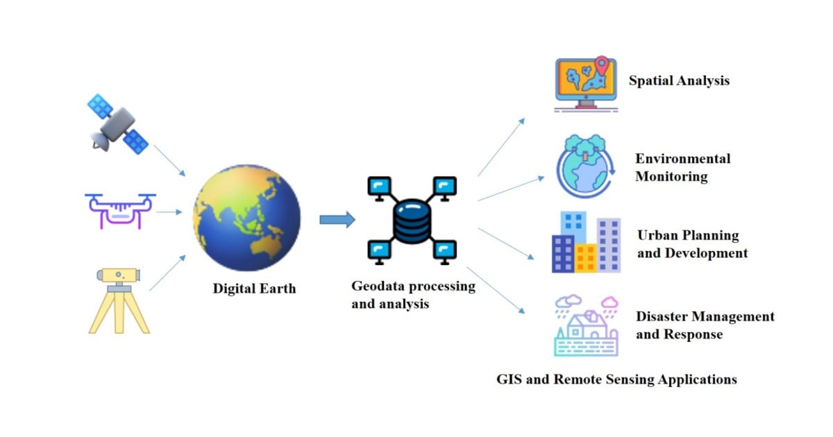
This Special Issue aims to explore the intersection between Geographic Information Systems (GISs) and remote sensing in the realm of Digital Earth. It seeks to gather innovative research that highlights the latest advancements, challenges, and opportunities in applying GIS and remote sensing techniques to digitalize, analyze, and understand our planet. The scope encompasses various aspects of GIS and remote sensing, including data acquisition, processing, analysis, visualization, and decision-making support, with a focus on their practical applications in environmental monitoring, urban planning, disaster management, agricultural practices, and other related fields. The Special Issue welcomes contributions from both academic researchers and industry professionals, emphasizing real-world case studies and practical solutions.

This Special Issue will provide a platform for scholars and practitioners to share their insights, experiences, and best practices in leveraging GIS and remote sensing for the advancement of Digital Earth. Through this collection of articles, we aim to contribute to the growing body of knowledge in this exciting and dynamic field.

Dr. Zhaojin Yan
Dr. Xiao Zhou
Guest Editors

Manuscript Submission Information

Manuscripts should be submitted online at www.mdpi.com by registering and logging in to this website. Once you are registered, click here to go to the submission form. Manuscripts can be submitted until the deadline. All submissions that pass pre-check are peer-reviewed. Accepted papers will be published continuously in the journal (as soon as accepted) and will be listed together on the special issue website. Research articles, review articles as well as short communications are invited. For planned papers, a title and short abstract (about 100 words) can be sent to the Editorial Office for announcement on this website.

Submitted manuscripts should not have been published previously, nor be under consideration for publication elsewhere (except conference proceedings papers). All manuscripts are thoroughly refereed through a single-blind peer-review process. A guide for authors and other relevant information for submission of manuscripts is available on the Instructions for Authors page. Applied Sciences is an international peer-reviewed open access semimonthly journal published by MDPI.

Please visit the Instructions for Authors page before submitting a manuscript. The Article Processing Charge (APC) for publication in this open access journal is 2400 CHF (Swiss Francs). Submitted papers should be well formatted and use good English. Authors may use MDPI's English editing service prior to publication or during author revisions.

Keywords

  • GIS applications
  • remote sensing
  • digital earth
  • spatial analysis
  • environmental monitoring
  • urban planning and development
  • disaster management and response
  • big data analytics in GIS and remote sensing

Benefits of Publishing in a Special Issue

  • Ease of navigation: Grouping papers by topic helps scholars navigate broad scope journals more efficiently.
  • Greater discoverability: Special Issues support the reach and impact of scientific research. Articles in Special Issues are more discoverable and cited more frequently.
  • Expansion of research network: Special Issues facilitate connections among authors, fostering scientific collaborations.
  • External promotion: Articles in Special Issues are often promoted through the journal's social media, increasing their visibility.
  • e-Book format: Special Issues with more than 10 articles can be published as dedicated e-books, ensuring wide and rapid dissemination.

Further information on MDPI's Special Issue policies can be found here.

Published Papers (8 papers)

Order results
Result details
Select all
Export citation of selected articles as:

Research

Jump to: Review

26 pages, 17512 KiB  
Article
Evaluation of the Suitability of Urban Underground Space Development Based on Multi-Criteria Decision-Making and Geographic Information Systems
by Peixing Zhang, Tianlu Jin, Meng Wang, Na Zhou and Xueting Jia
Appl. Sci. 2025, 15(2), 543; https://doi.org/10.3390/app15020543 - 8 Jan 2025
Cited by 1 | Viewed by 715
Abstract
The rational development of urban underground space resources (UUSRs) is especially crucial for alleviating “urban diseases”, and it is of great significance for exploring the appropriateness of urban underground space (UUS) development under multiple constraints for the rational use of UUSRs. This research [...] Read more.
The rational development of urban underground space resources (UUSRs) is especially crucial for alleviating “urban diseases”, and it is of great significance for exploring the appropriateness of urban underground space (UUS) development under multiple constraints for the rational use of UUSRs. This research selects the UUS in Nantong City, Jiangsu Province, as the research object, and establishes an evaluation index system for the suitability of UUS development under the perspective of sustainable development, including terrain and geomorphology, engineering geological environment, hydrogeological environment, sensitive geological factors, the regional development level, and the distribution of ecological reserve, as well as other multi-source heterogeneous data. On this basis, the relationship between the appropriateness of underground space development and the utilization and various factors was studied. We constructed a comprehensive evaluation model for the suitability of UUS using the Analytic Hierarchy Process (AHP) and the multi-objective linear weighting method. The results of the study show that ecological protection constraints and geological hazards have a greater impact on the evaluation of suitability. The suitable and secondarily suitable areas for the development of the underground space in Nantong City account for 14.74% and 30.66% of the total area, respectively. These areas are mainly distributed in Rugao City and Chongchuan District. The less suitable and unsuitable areas account for 37.17% and 17.44%, with a significant concentration in near-sea areas. Full article
Show Figures

Figure 1

25 pages, 21410 KiB  
Article
Enhancing Disaster Situation Awareness Through Multimodal Social Media Data: Evidence from Typhoon Haikui
by Songfeng Gao, Tengfei Yang, Yuning Xu, Naixia Mou, Xiaodong Wang and Hao Huang
Appl. Sci. 2025, 15(1), 465; https://doi.org/10.3390/app15010465 - 6 Jan 2025
Cited by 1 | Viewed by 1173
Abstract
Emergency situation awareness during sudden natural disasters presents significant challenges. Traditional methods, characterized by low spatial and temporal resolution as well as coarse granularity, often fail to comprehensively capture disaster situations. However, social media platforms, as a vital source of social sensing, offer [...] Read more.
Emergency situation awareness during sudden natural disasters presents significant challenges. Traditional methods, characterized by low spatial and temporal resolution as well as coarse granularity, often fail to comprehensively capture disaster situations. However, social media platforms, as a vital source of social sensing, offer significant potential to supplement disaster situational awareness. This paper proposes an innovative framework for disaster situation awareness based on multimodal data from social media to identify social media content related to typhoon disasters. Integrating text and image data from social media facilitates near real-time monitoring of disasters from the public perspective. In this study, Typhoon Haikui (Strong Typhoon No. 11 of 2023) was chosen as a case study to validate the effectiveness of the proposed method. We employed the ERNIE natural language processing model to complement the Deeplab v3+ deep learning image semantic segmentation model for extracting disaster damage information from social media. A spatial visualization analysis of the disaster-affected areas was performed by categorizing the damage types. Additionally, the Geodetector was used to investigate spatial heterogeneity and its underlying factors. This approach allowed us to analyze the spatiotemporal patterns of disaster evolution, enabling rapid disaster damage assessment and facilitating emergency response efforts. The results show that the proposed method significantly enhances situational awareness by effectively identifying different types of damage information from social sensing data. Full article
Show Figures

Figure 1

18 pages, 7089 KiB  
Article
Analysis of Vegetation Coverage Changes and Influencing Factors in Aksu, Xinjiang, China (2000–2020): A Comparative Study of Climate Factors and Urban Development
by Zhimin Feng, Haiqiang Xin, Hairong Liu, Yong Wang and Junhai Wang
Appl. Sci. 2024, 14(24), 12000; https://doi.org/10.3390/app142412000 - 21 Dec 2024
Cited by 1 | Viewed by 1050
Abstract
The ecological environment is fundamental to human survival and development, and China has seen a historical shift from localized to widespread improvements in its ecological conditions. Aksu, a typical ecologically sensitive region in Xinjiang, China, is significant for the study of vegetation dynamics [...] Read more.
The ecological environment is fundamental to human survival and development, and China has seen a historical shift from localized to widespread improvements in its ecological conditions. Aksu, a typical ecologically sensitive region in Xinjiang, China, is significant for the study of vegetation dynamics and their driving factors, which is crucial for ecological conservation. This study evaluates the spatiotemporal changes in vegetation coverage in Aksu from 2000 to 2020 using long-term Normalized Difference Vegetation Index (NDVI) data and trend analysis. Additionally, this study explores key factors influencing vegetation changes through correlation analysis with temperature, precipitation, and nighttime light data. The results indicate the following: (1) vegetation coverage in Aksu exhibits significant spatial heterogeneity, with annual NDVI increasing at a rate of 0.83% per year (p < 0.05); (2) the influence of temperature and precipitation on NDVI was weakly correlated from 2000 to 2020; and (3) a strong positive correlation was found between nighttime light intensity and NDVI, suggesting that urban development plays a dominant role in vegetation change, while temperature and precipitation have comparatively minor impacts. The findings provide a scientific basis for ecological conservation and sustainable development in the region. Full article
Show Figures

Figure 1

33 pages, 15088 KiB  
Article
A Multi-Criteria GIS-Based Approach for Risk Assessment of Slope Instability Driven by Glacier Melting in the Alpine Area
by Giulia Castellazzi and Mattia Previtali
Appl. Sci. 2024, 14(24), 11524; https://doi.org/10.3390/app142411524 - 11 Dec 2024
Viewed by 1205
Abstract
Climate change is resulting in significant transformations in mountain areas all over the world, causing the melting of glacier ice, reduction in snow accumulation, and permafrost loss. Changes in the mountain cryosphere are not only modifying flora and fauna distributions but also affecting [...] Read more.
Climate change is resulting in significant transformations in mountain areas all over the world, causing the melting of glacier ice, reduction in snow accumulation, and permafrost loss. Changes in the mountain cryosphere are not only modifying flora and fauna distributions but also affecting the stability of slopes in those regions. For all these reasons, and because of the risks these phenomena pose to the population, the dentification of dangerous areas is a crucial step in the development of risk reduction strategies. While several methods and examples exist that cover the assessment and computation of single sub-components, there is still a lack of application of risk assessment due to glacier melting over large areas in which the final result can be directly employed in the design of risk mitigation policies at regional and municipal levels. This research is focused on landslides and gravitational movements on slopes resulting from rapid glacier melting phenomena in the Valle d’Aosta region in Italy, with the aim of providing a tool that can support spatial planning in response to climate change in Alpine environments. Through the conceptualization and development of a GIS-based and multi-criteria approach, risk is then estimated by defining hazard indices that consider different aspects, combining the experience acquired from studies carried out in various disciplinary fields, to obtain a framework at the regional level. This first assessment is then deepened for the Lys River Valley, where the mapping of hazardous areas was implemented, obtaining a classification of buildings according to their hazard score to estimate the potential damage and total risk relating to possible slope instability events due to ice melt at the local scale. Full article
Show Figures

Figure 1

17 pages, 5076 KiB  
Article
A Scene–Object–Economy Framework for Identifying and Validating Urban–Rural Fringe Using Multisource Geospatial Big Data
by Ganmin Yin, Ying Feng, Yanxiao Jiang and Yi Bao
Appl. Sci. 2024, 14(22), 10191; https://doi.org/10.3390/app142210191 - 6 Nov 2024
Viewed by 1033
Abstract
Rapid urbanization has led to the emergence of urban–rural fringes, complex transitional zones that challenge traditional urban–rural dichotomies. While these areas play a crucial role in urban development, their precise identification remains a significant challenge. Existing methods often rely on single-dimensional metrics or [...] Read more.
Rapid urbanization has led to the emergence of urban–rural fringes, complex transitional zones that challenge traditional urban–rural dichotomies. While these areas play a crucial role in urban development, their precise identification remains a significant challenge. Existing methods often rely on single-dimensional metrics or administrative boundaries, failing to capture the multi-faceted nature of these zones. This study introduces a novel “Scene–Object–Economy” (SOE) framework to address these limitations and enhance the precision of urban–rural fringe identification. Our approach integrates multisource geospatial big data, including remote sensing imagery, nightlight data, buildings, and Points of Interest (POI), leveraging machine learning techniques. The SOE framework constructs feature from three dimensions: scene (image features), object (buildings), and economy (POIs). This multidimensional methodology allows for a more comprehensive and nuanced mapping of urban–rural fringes, overcoming the constraints of traditional methods. The study demonstrates the effectiveness of the SOE framework in accurately delineating urban–rural fringes through multidimensional validation. Our results reveal distinct spatial patterns and characteristics of these transitional zones, providing valuable insights for urban planners and policymakers. Furthermore, the integration of dynamic population data as a separate layer of analysis offers a unique perspective on population distribution patterns within the identified fringes. This research contributes to the field by offering a more robust and objective approach to urban–rural fringe identification, laying the groundwork for improved urban management and sustainable development strategies. The SOE framework presents a promising tool for future studies in urban spatial analysis and planning. Full article
Show Figures

Figure 1

26 pages, 32948 KiB  
Article
Implications for Paleontological Heritage Conservation: The Spatial Distribution and Potential Factors Controlling the Location of Fossil Sites of Shandong Province in China
by Ying Guo, Yu Sun, Xiaoying Han, Yan Zhao, Song Zhou, Yachun Zhou, Tian He and Yingming Yang
Appl. Sci. 2024, 14(21), 9843; https://doi.org/10.3390/app14219843 - 28 Oct 2024
Viewed by 1159
Abstract
Shandong Province in China is rich in paleontological fossils and has a long history of fossil research. However, research on the distribution characteristics and potential factors of discovered fossil sites in Shandong Province is limited and insufficient, making it difficult to comprehensively plan [...] Read more.
Shandong Province in China is rich in paleontological fossils and has a long history of fossil research. However, research on the distribution characteristics and potential factors of discovered fossil sites in Shandong Province is limited and insufficient, making it difficult to comprehensively plan for the protection and utilization of fossil sites in Shandong Province. The study constructs a basic geographical information system (GIS) database with 133 discovered fossil sites and geological and socio-economic data of Shandong Province and studies fossil sites’ spatial distribution characteristics and the spatial relationship with potential factors at a regional scale. The results are as follows: (1) The fossil sites in Shandong Province are concentrated in the mountainous area of central Shandong and the hilly area of the Shandong Peninsula, with significant uneven distribution characteristics, including two agglomeration areas and seven sub-agglomeration areas. (2) Natural geographical conditions, such as topography, paleogeography, and stratigraphy, play a positive role in the distribution of fossil sites, and there are apparent concentrations in the following areas: at an altitude greater than 100 m; the Lower Paleozoic and Cretaceous sedimentary rocks; and the active areas of paleo-tectonics. (3) A certain degree of negative correlation exists between socio-economic conditions, such as roads and population density, and the number of fossil sites, and a positive correlation exists between disposable personal income and those fossil sites. The operational procedure presented here is a simple, objective, applicable method that can enhance our understanding of the spatial distribution patterns and influencing factors of the discovered fossil sites of Shandong Province and support more effective and appropriate planning for paleontological heritage conservation. Full article
Show Figures

Figure 1

15 pages, 8419 KiB  
Article
Capturing Snowmelt Runoff Onset Date under Different Land Cover Types Using Synthetic Aperture Radar: Case Study of Sierra Nevada Mountains, USA
by Bing Gao and Wei Ma
Appl. Sci. 2024, 14(15), 6844; https://doi.org/10.3390/app14156844 - 5 Aug 2024
Viewed by 1030
Abstract
Snow plays a crucial role in the global water and energy cycles, and its melting process can have a series of impacts on hydrological or climatic systems. Accurately capturing the timing of snowmelt runoff is essential for the utilization of snow resources and [...] Read more.
Snow plays a crucial role in the global water and energy cycles, and its melting process can have a series of impacts on hydrological or climatic systems. Accurately capturing the timing of snowmelt runoff is essential for the utilization of snow resources and the early warning of snow-related disasters. A synthetic aperture radar (SAR) offers an effective means for capturing snowmelt runoff onset dates (RODs) over large areas, but its accuracy under different land cover types remains unclear. This study focuses on the Sierra Nevada Mountains and surrounding areas in the western United States. Using a total of 3117 Sentinel-1 images from 2017 to 2023, we extracted the annual ROD based on the Google Earth Engine (GEE) platform. The satellite extraction results were validated using the ROD derived from the snow water equivalent (SWE) data from 125 stations within the study area. The mean absolute errors (MAEs) for the four land cover types—tree cover, shrubland, grassland, and bare land—are 24, 18, 18, and 16 d, respectively. It indicates that vegetation significantly influences the accuracy of the ROD captured from Sentinel-1 data. Furthermore, we analyze the variation trends in the ROD from 2017 to 2023. The average ROD captured by the stations shows an advancing trend under different land cover types, while that derived from Sentinel-1 data only exhibits an advancing trend in bare land areas. It indicates that vegetation leads to a delayed trend in the ROD captured by using Sentinel-1 data, opposite to the results from the stations. Meanwhile, the variation trends of the average ROD captured by both methods are not significant (p > 0.05) due to the impact of the extreme snowfall in 2023. Finally, we analyze the influence of the SWE on RODs under different land cover types. A significant correlation (p < 0.05) is observed between the SWE and ROD captured from both stations and Sentinel-1 data. An increase in the SWE causes a delay in the ROD, with a greater delay rate in vegetated areas. These findings will provide vital reference for the accurate acquisition of the ROD and water resources management in the study area. Full article
Show Figures

Figure 1

Review

Jump to: Research

19 pages, 2829 KiB  
Review
Monitoring and Prediction of Land Surface Phenology Using Satellite Earth Observations—A Brief Review
by Mateo Gašparović, Ivan Pilaš, Dorijan Radočaj and Dino Dobrinić
Appl. Sci. 2024, 14(24), 12020; https://doi.org/10.3390/app142412020 - 22 Dec 2024
Cited by 1 | Viewed by 1283
Abstract
Monitoring and predicting land surface phenology (LSP) are essential for understanding ecosystem dynamics, climate change impacts, and forest and agricultural productivity. Satellite Earth observation (EO) missions have played a crucial role in the advancement of LSP research, enabling global and continuous monitoring of [...] Read more.
Monitoring and predicting land surface phenology (LSP) are essential for understanding ecosystem dynamics, climate change impacts, and forest and agricultural productivity. Satellite Earth observation (EO) missions have played a crucial role in the advancement of LSP research, enabling global and continuous monitoring of vegetation cycles. This review provides a brief overview of key EO satellite missions, including the advanced very-high resolution radiometer (AVHRR), moderate resolution imaging spectroradiometer (MODIS), and the Landsat program, which have played an important role in capturing LSP dynamics at various spatial and temporal scales. Recent advancements in machine learning techniques have further enhanced LSP prediction capabilities, offering promising approaches for short-term prediction of vegetation phenology and cropland suitability assessment. Data cubes, which organize multidimensional EO data, provide an innovative framework for enhancing LSP analyses by integrating diverse data sources and simplifying data access and processing. This brief review highlights the potential of satellite-based monitoring, machine learning models, and data cube infrastructure for advancing LSP research and provides insights into current trends, challenges, and future directions. Full article
Show Figures

Figure 1

Back to TopTop