Abstract
Wayfinding with minimal effort is essential for reducing cognitive load and emotional stress in unfamiliar environments. This exploratory quasi-experimental study investigated wayfinding challenges in a university building housing three spatially dispersed counseling centers and three academic departments that share the building entrances, lobby, and hallways. Using mobile eye tracking with concurrent think-aloud protocols and schematic mapping, we examined visual attention patterns during predefined navigation tasks performed by 24 first-time visitors. Findings revealed frequent fixations on non-informative structural features, while existing wayfinding cues were often overlooked. High rates of null gazes indicated unsuccessful visual searching. Thematic analysis of verbal data identified eight key issues, including spatial confusion, aesthetic monotony, and inadequate signage. Participants frequently described the environment as disorienting and emotionally taxing, comparing it to institutional settings such as hospitals. In response, we developed wayfinding design proposals informed by our research findings, stakeholder needs, and contextual priorities. We used an experiential digital twin that prioritized perceptual fidelity to analyze the current wayfinding challenges, develop experimental protocols, and discuss design options and costs. This study offers a transferable methodological framework for identifying wayfinding challenges through convergent analysis of gaze patterns and verbal protocols, demonstrating how empirical findings can inform targeted wayfinding design interventions.
1. Introduction
Easy navigation in complex interior environments plays a pivotal role in shaping visitor experiences, reducing anxiety, and ensuring functional efficiency. This is especially critical in healthcare and counseling settings, where users often arrive under various vulnerabilities, including physical challenges and psychological distress. Even seemingly minor spatial ambiguities (e.g., unclear signs or similar corridors) can lead to navigation errors that compound emotional strain and compromise the quality of healthcare services.
Wayfinding refers to the multifaceted process by which individuals orient themselves, make navigational decisions, and move toward a destination [1]. Successful wayfinding in a building depends on the environmental legibility—intuitive spatial hierarchies, clearly identifiable landmarks, and consistent visual cues [2]. Yet, in an institutional building where multiple academic and service divisions with varying functions are co-located, navigation is often hindered by fragmented spatial logic, configural uniformity, and a lack of an integrated environmental identity. These issues can have outsized effects in counseling settings, where users are often first-time visitors unfamiliar with the environment and simultaneously coping with emotional distress. To mitigate misrouting and delay for first-time visitors, staff often escort them from the building entrance to the centers’ shared check-in office, underscoring the need for a clearer interior wayfinding system.
Although a substantial body of research has examined wayfinding through post-occupancy evaluations and spatial syntax analyses, such approaches may overlook the dynamic cognitive and emotional processes users experience in real-time. Advances in mobile eye-tracking technology now allow researchers to capture fine-grained visual behavior during actual navigation tasks. By analyzing where users’ gazes fixate, what visual information is overlooked, and how visual search unfolds, eye tracking can reveal mismatches between user expectations and environmental affordances [3,4]. When paired with concurrent think-aloud protocols, which document users’ immediate thoughts, potential strategies, and emotional responses, this mixed-methods approach offers a robust means of uncovering both the cognitive and affective dimensions of spatial experience [5].
This exploratory quasi-experimental study investigates wayfinding challenges within a university building that houses three spatially distributed counseling centers, sharing common areas with three other academic units. The facility’s complex layout, lack of visual differentiation, and limited signage systems were presumed to affect user disorientation and stress. This study employs a mixed-methods approach combining in situ (on-site, in the actual building) eye tracking with concurrent think-aloud protocols. Given the gap between existing research methods and the complexity of wayfinding behavior, the emphasis is on developing transferable methodology for identifying wayfinding barriers rather than comparing performance across demographic groups or testing hypotheses. Research participants, who were first-time visitors to the building, completed predefined navigation tasks independently while verbalizing their thoughts in real time. The research questions are: (1) What environmental elements or factors influence gaze behavior during wayfinding in an institutional setting?; (2) How do gaze patterns reflect visual attention and cognitive processing during wayfinding in complex environments?; (3) How can individuals’ visual attention inform design strategies that support first-time visitors’ navigation and reduce cognitive load?
Notably, this study also includes a co-design phase in which findings from eye tracking and verbal data were shared with key stakeholders, including facility administrators, counselors, and student representatives, to co-create targeted design solutions. Rather than treating current building users as passive recipients of imposed design solutions, we actively involved them in the co-design process, including initial visioning of the project and brainstorming about the current use of the space and end-user needs and desires. The resulting design proposals emphasize inclusive, emotionally responsive, and cognitively supportive wayfinding design strategies, such as color-coded spatial identities, strategically placed directional cues, and visually distinct wayfinding landmarks positioned at key decision points to ease spatial comprehension and reduce mental effort.
By linking empirical research with co-design practices, this study provides a replicable, evidence-based framework for identifying and addressing wayfinding barriers in complex institutional environments. It advances methodological rigor in research on visual attention and spatial cognition while offering practical insights for designers and administrators seeking to enhance user-centered wayfinding systems, especially in facilities that serve cognitively or emotionally challenged populations.
2. Literature Review
This literature review provides the context and concepts underpinning this study, including foundational theories and empirical research on environmental cognition, visual attention, and user experience.
2.1. Information Processing in Human-Environment Interaction
Information processing is the process by which individuals perceive, interpret, and respond to sensory inputs from the surrounding environment through cognitive mechanisms. Lindsay and Norman [6] presented human information processing through three broad stages: sensation, perception, and cognition. Sensation is the initial detection of environmental stimuli; perception is the subsequent stage in which signals are organized through neural processing and interpreted into meaningful experiences; cognition integrates higher-level processes, including memory, recognition, decision-making, categorization, problem-solving, and planning.
When individuals navigate a building, the effectiveness of their wayfinding depends on their selective perception and attention to environmental information in the space. Cognitive mapping refers to the dynamically updated mental construction formed through active spatial perception, selective attention, and memory retrieval [7]. Perception of spatial context includes both selective attention to salient environmental cues (such as signage or landmarks) and ambient or incidental perception of environmental conditions that may influence wayfinding without conscious awareness (Figure 1). These perceptual processes provide the informational foundation for two parallel but complementary pathways: intuitive wayfinding and signage-based wayfinding [8].
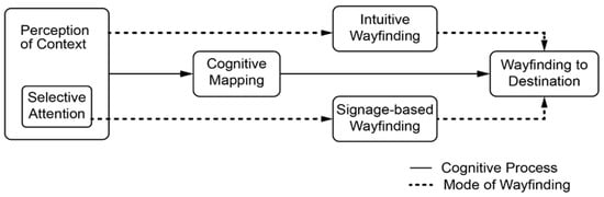
Figure 1.
Information processing in wayfinding.
Intuitive wayfinding is conceptually linked to Kaplan and Kaplan’s [9] environmental preference theory, which explains four primary aspects—coherence, legibility, complexity, and mystery—of environmental settings that influence people’s perception of their surroundings. This framework has been further supported through meta-analytic review [10]. These aspects fundamentally affect individuals’ visual attention and, thus, wayfinding, whether positively or negatively. Signage-based wayfinding, on the other hand, provides explicit information and involves the cognitive process of selective attention, in which users filter spatial information to focus on cues that are explicitly designed to support navigation. The integration between the two pathways reinforces each other to inform the construction and updating of cognitive maps that guide navigation decisions [8].
Lynch’s [2] concepts of environmental legibility and imageability have significantly influenced research on how individuals cognitively engage with their surroundings. Adequately legible environments support wayfinding by presenting clear paths, distinct landmarks, and coherent spatial contexts and hierarchies that aid in the development of accurate cognitive maps. This is particularly important in healthcare contexts, where patients and visitors often navigate under stress and time constraints.
Another important property of a spatial setting is affordance, which refers to the perceived and physical properties of an object or environmental setting that indicate potential modes of interaction [11]. Norman [12] later refined the concept, arguing that the value of affordance lies not only in physical presence but in the user’s ability to perceive it. In Norman’s formulation, objects and spatial features guide behavior only when the actionable qualities are legible to the intended user. In wayfinding applications, affordance can be translated into wayfinding cues that enable people to navigate without conscious effort.
2.2. Wayfinding in Built Environments
Contemporary research has examined how the built environment affects users’ ability to navigate healthcare facilities, and has identified several spatial and visual factors that directly affect wayfinding performance, such as configuration clarity [13], visual access to destinations [14], signage systems [15], and the distinctiveness of spatial zones. In environments where corridors are visually uniform, directional cues are ambiguous, or decision points are poorly marked, users often experience elevated cognitive load and navigation errors. Such challenges are exacerbated in large institutional facilities where multiple departments, functions, and circulation paths converge; the complexity of the spatial system amplifies wayfinding challenges—making spatial legibility a critical dimension of design effectiveness.
To navigate such environments, users draw on a range of signage-based wayfinding cues, including maps, directional signage, room numbers, and architectural features such as stairs, intersections, and corridor terminations. They also rely on more diffused environmental affordances that affect intuitive wayfinding, including gradients in lighting, ceiling height, material changes, and spatial sequence. The effectiveness of a wayfinding system depends not only on the availability of these cues but also on how well they align with users’ perceptual expectations and cognitive strategies.
Effective wayfinding systems help reduce cognitive strain and support intuitive comprehension by guiding attention toward relevant spatial features and minimizing ambiguity at key decision points [16]. Proper categorization of information serves this purpose. For example, color-coded visual cues effectively serve this purpose in spatial navigation and wayfinding. As a visual language, strategic use of color can enhance human-environment interaction and communication [17]. These perceptual-cognitive interactions are difficult to observe directly, making methods like mobile eye tracking an increasingly valuable method for examining how users engage with the built environment in real-time.
2.3. Eye Tracking in Wayfinding Research
Researchers have increasingly adopted eye tracking to investigate visual attention during wayfinding, providing insights into how users process environmental information while navigating built environments. Early research focused on recording gaze fixations and scanpaths to understand what visual features attract attention during navigation tasks. Studies comparing different navigation aids revealed that users exhibit distinct gaze patterns when using GPS-based systems versus traditional maps, with implications for how environmental features are visually processed during wayfinding [18]. Research in outdoor environments demonstrated that gaze behavior differs significantly between incidental and intentional navigation, with intentional wayfinding producing more systematic scanning patterns [19].
Recognizing the limitations of gaze data alone, researchers began integrating complementary methods to interpret the reasoning behind gaze behavior. Mobile eye tracking combined with advanced analytical approaches has enabled researchers to investigate navigation processes in real-world settings [20]. More recent work has expanded these approaches to interior environments and commercial settings. Kwon and Kim [21] integrated eye tracking with retrospective interviews to examine how users interpret spatial experiences in designed environments, demonstrating how gaze data can inform our understanding of environmental perception beyond navigation tasks. However, the study used retrospective interviews without concurrent think-aloud, which limits access to immediate, in situ interpretations needed to disambiguate fixation targets and intentions. In addition, the visual stimuli used in the study comprised photo images displayed on a computer screen rather than in situ navigation, which reduces ecological validity.
2.4. Wayfinding in Healthcare Settings
Wayfinding challenges have particular significance in healthcare and counseling environments where users often arrive under physical or psychological distress. Environmental elements and factors—such as lighting, acoustics, spatial layout, and signage—influence stress responses, perceptions of safety, and user satisfaction in healthcare settings [22,23]. In mental and behavioral health settings, where visitors may already be in vulnerable psychological states, poor wayfinding systems can exacerbate anxiety, disorientation, and cognitive load. Elevated stress and anxiety levels can obstruct cognitive functioning necessary for effective spatial orientation and navigation [24], making clear wayfinding systems essential in these settings.
Effective wayfinding systems not only support spatial orientation and autonomy but also contribute to broader outcomes such as reduced anxiety, improved service accessibility, and increased trust in institutional settings [25].
2.5. Using Digital Twins in User-Centered Design Process
In recent years, digital twins—virtual replicas of physical spaces synchronized with real-world conditions—have gained momentum in design disciplines as tools for simulation, evaluation, and iterative planning. In the built environment, digital twins range from building-level asset management systems to urban-scale planning models. They are often grounded in building information modeling (BIM) and enriched with real-time data from environmental sensors, such as occupancy, temperature, and energy performance monitors, to support energy modeling, asset management, and operational planning [26]. Definitions vary, but most agree on their core characteristics: spatial fidelity, ongoing data integration, and the ability to support decision-making [27,28,29]. Digital twins are increasingly used to simulate spatial settings and evaluate user-centered design decisions. A pioneering study proposing a participatory model used a high-fidelity digital twin to create an immersive environment for evaluating end-user experience, combining gaze and verbal feedback to inform design processes and decisions [30]. This approach helped establish a methodological foundation that has since been adopted in subsequent frameworks across other domains. Commercial deployments like Treedis’s [31] virtual twin of the Garni Hotel illustrate how interactive walkthroughs can reveal navigation challenges in hospitality settings. Environmental design research has also explored digital-twin integration, including a study on perceptual clarity and usability among elderly hospital participants and staff [32]. Earlier behavioral studies, including Ishikawa et al. (2008) [18], contributed to a broader understanding of spatial decision-making, though they did not involve digital simulation or twin-based methodologies.
In this study, we used a BIM-based experiential digital twin—optimized for spatial and perceptual fidelity—to analyze the existing setting, develop experimental protocols, test design options, and simulate end-user wayfinding patterns. This discrete, experience-based synchronization is suited to design decision-making and is distinct from operations-oriented digital twins for telemetry and supervisory control, which lie outside the scope of this study.
3. Research Design and Methods
This exploratory quasi-experimental study employed a multi-phase research design to systematically analyze the spatial context, examine first-time visitors’ visual attention in the counseling center spaces, and develop wayfinding design interventions for those spaces in a university building. As illustrated in Figure 2, the research process was structured into three sequential stages—spatial context analysis, visual attention research, and wayfinding design intervention—each building on the findings of the previous phase. This structure reflects both the intent of the study designed for specific client stakeholders and its grounding in user-centered evaluation. First, the spatial and operational context was examined through floor plan analysis, mapping navigation paths and decision points, and gathering input from counselors and staff with firsthand knowledge of user experiences. The second stage involved in situ eye tracking and concurrent think-aloud protocols to capture participants’ gaze behavior and associated emotional responses. These data were analyzed to identify gaze patterns, confusion points, and cognitive responses to the environment. In the final stage, findings from the previous phases informed the development of new wayfinding design, including the strategic coding and placement of visual cues to support visitors’ wayfinding in the building. This iterative, mixed-methods approach demonstrates a direct linkage between empirical data and design strategies, ensuring that the interventions are grounded in empirical research and responsive to site-specific conditions and user-specific needs.
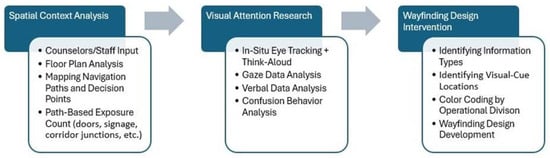
Figure 2.
Research design including three workflows.
3.1. Methodological Rationale
Mobile eye tracking in real-world navigation presents unique analytical challenges. Traditional AOI-based analysis, commonly used in screen-based eye-tracking studies, assumes equal exposure to defined areas of interest. However, during physical navigation, exposure to visual elements is route-dependent and varies with each participant’s moment-to-moment field of view. This makes hypothesis testing based on AOIs problematic for in situ wayfinding research.
Furthermore, gaze data alone cannot reveal the reasoning behind fixation patterns. When participants navigate complex buildings, understanding why they look at certain features—and what they interpret from those fixations—requires capturing their immediate cognitive processes.
To address these limitations, this study adopts in-situ data collection and pairs mobile eye tracking with concurrent think-aloud protocols. This methodological approach disambiguates fixation targets and intentions at decision points, links moment-to-moment visual uptake to evolving interpretation and strategy, and generates contextual evidence that is not available from gaze-only data or still-image-only stimuli.
3.2. Research Site
This study used a three-story university building housing three interconnected counseling and therapy centers that share common areas with three academic departments. The three zones the centers occupy are largely located on the first floor, and an exam area on the third floor. The centers serve diverse user populations, including students, families, and community members seeking services.
We conducted a systematic site analysis of the counseling centers to document the architectural and wayfinding conditions that could affect first-time visitors’ navigation in the building. The analysis examined room and door distribution, corridor junctions, decision points, visual conditions along entry-to-destination paths, and spatial conditions affecting signage legibility and wayfinding clarity. The procedures included five phases:
- Floor Plan Evaluation: Spaced on each floor were examined using architectural plans. Rooms were counted based on labeled numeric designations, excluding vestibules, and storage- and mechanical rooms.
- Interior Doorway Count: Each floor was analyzed to count interior doorways visible from primary circulation paths.
- Path-Based Door Exposure: Doorways physically passed and visually encountered along the path to the main check-in office for all three centers were counted. Visual exposure included all doors visible from the path, even if not physically traversed.
- Decision Point Estimation: Points where first-time visitors—without prior knowledge of the space—would need to pause to make navigation decisions were estimated. These included points of directional uncertainty (e.g., T-junctions and corridor turns).
- Confusion Behavior Mapping: Based on spatial features such as ambiguous junctions, broken number sequences, and poor visibility, we projected how many times a user would likely show visible signs of confusion.
This building analysis served as a foundation for designing our research protocols, including the wayfinding prompts used during eye-tracking experiments. We identified the building interior elements likely to trigger uncertainty or delay in navigation and developed prompts for wayfinding tasks for research participants.
3.3. Equipment
A mobile eye-tracking device (Tobii Pro Glasses 2) was used for the in situ experiments to collect gaze data at a 50 Hz sampling rate, which allows precise mapping of fixations onto visual features during physical navigation, increasing the ecological validity of the study.
A BIM-based experiential digital twin—a computer-generated replica—of the current space was created using Autodesk Revit to simulate user experience both before (pre-design) and after (post-design) interventions, with discrete, experience-based synchronization and no live BMS/IoT control; definitions and scope are provided in Section 2.5. In this paper, digital twin follows a purpose-driven definition: a virtual representation synchronized with its physical referent at a specified frequency and fidelity, with cadence tailored to the use case [33]. Our application is in experimental protocol development and throughout design processes, which prioritize spatial and perceptual fidelity to examine end-user experience and provide new interventions. This distinguishes the field-specific use of digital twins from operations-oriented twins focused on telemetry and supervisory control [34]. This trade-off aligns with occupant-centric digital twins that emphasize navigable, real-world interiors [35].
The experiential digital twin, built during the early project phase, supported multiple aspects of this study: initial analysis of the existing building space, development of experimental protocols, communication with stakeholders, simulation of proposed design interventions, and discussion on costs.
3.4. Participants
The research adopted purposive sampling. A total of 24 participants, aged 18 to 25, were recruited from a single interior design course. To minimize the influence of extraneous factors, all participants were first-time visitors to the study site and were undergraduate students from the same cohort, ensuring that they had similar levels of proficiency in spatial comprehension and terminology use. Participants were screened for normal or corrected-to-normal vision and color vision deficiencies, using standardized tests. None of the participants had prior experience navigating the building or knowledge of the counseling centers’ existence in the building. This study was conducted in collaboration with stakeholder input from the counseling centers housed in the building. Stakeholder input indicated that vulnerable populations, including the centers’ current patients, should not be recruited for ethical reasons. The selected age range aligns with the university student population that comprises a substantial portion of the centers’ users from the campus community. The interior design student cohort was selected as they could provide rich, detailed verbal descriptions of spatial features required for the concurrent think-aloud protocol. While this limits generalizability across age groups and visitor types, the controlled sample was suitable for this exploratory, quasi-experimental study, which focused on methodological development rather than group comparisons. Broader demographic sampling and longitudinal studies are discussed in Section 6.
3.5. Data Collection
After providing informed consent, participants completed a color-deficiency test and vision screening to ensure the quality of gaze data. Participants received standardized instructions describing a scenario in which they were clients visiting the counseling centers to receive counseling and a clinical exam, requiring navigation through multiple floors and room types. Each participant wore a glasses-type mobile eye tracker during the task. While navigating, they were instructed to think aloud, verbalizing their thoughts, decisions, and impressions related to the space and wayfinding tasks. No time constraint was applied, and no navigational assistance was provided during the experiment. Gaze data and verbalizations were recorded simultaneously using the device’s integrated forward-facing scene camera and built-in microphone, allowing synchronized analysis of visual attention and participant commentary.
3.6. Data Analysis Procedures
3.6.1. Gaze Data Analysis
Gaze data analysis began with time-ordered mobile eye-tracking video with a moving viewpoint. Our analytic unit is the spatiotemporal sequence of mapped fixation points obtained through schematic fixation-point mapping, not static image AOIs. Eye-tracking streams were pre-filtered in Tobii Pro Lab to obtain fixations for subsequent mapping, using the I-VT (Identification by Velocity Threshold) algorithm, which excluded saccades and transient glances (minimum duration threshold: 60 milliseconds). This filtering step isolated sustained fixations, providing a clean baseline for subsequent mapping.
For schematic mapping, a researcher-authored diagram of each floor was imported as a coding scaffold. Each floor’s schematic map comprised simplified diagrams organized by common navigational sequences with text labels corresponding to environmental features. Preliminary labels were refined during calibration, and the final labels used for coding were fixed prior to data entry (illustrative example in Figure 3). A third researcher independently repeated the protocol, with discrepancies resolved by discussion before finalizing the maps for data entry.
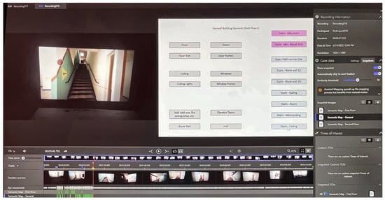
Figure 3.
Schematic mapping interface showing manual entry of fixation points into the schematic map.
While reviewing each recording in full, coders manually entered gaze fixations by frame into an associated schematic map—generally more than 200 entries per video—capturing where fixations occurred and in what sequence they unfolded across decision points. All analyses and interpretations rely on the schematic mapping; the approach prioritizes topological structure and sequence over raw density and favors interpretability and ecological validity over millisecond-level temporal precision. Entries were time-aligned within ±150 milliseconds; when multiple plausible targets were visible, priority was given to the item referenced in the think-aloud or the centrally fixated element; ambiguous/occluded frames were coded as null; left/right were defined relative to travel direction; labels functioned as coding anchors, not AOIs.
During coding, the synchronized think-aloud audio was used to disambiguate the identity of fixated content when the video alone was ambiguous (e.g., different spots on a single sign, door frames versus doors, etc.). Analyses remain grounded in the spatiotemporal sequence of mapped fixation points.
The schematic mapping approach was necessary because in mobile video, participants’ movement and shifting perspectives lead to unequal exposure and preclude fixed anchors, making AOI shares compositional and not commensurate across participants without strong normalizations. In this study, heatmaps are illustrative only; all analysis and interpretation rely on the schematic mapping of sequences and decision-point structure.
The researchers also piloted a software-assisted mapping approach. In mobile video with a moving viewpoint, assisted mapping lacked access to the matching verbal information provided by think-aloud and therefore could not reliably resolve fine-grained attention points (e.g., different spots on a single sign, door frames versus doors, height ranges on wall corners, etc.) when multiple plausible targets were visible. Assisted mapping was also sensitive to viewpoint drift and occlusions. This study thus adopted researcher-coded schematic mapping as the primary method.
For the coding process, three researchers participated. Two coders received the same training and jointly coded the data and finalized the codebook through calibration sessions on pilot recordings (including inclusion/exclusion rules and time-alignment guidelines). The full dataset was then partitioned into two non-overlapping sets, and each coder independently mapped one set using the schematic procedure. The principal investigator (PI) subsequently reviewed all coded entries across both sets and resolved any ambiguities in consultation with the original coder; minor clarifications were logged in the codebook. The workflow is illustrated in Figure 4.
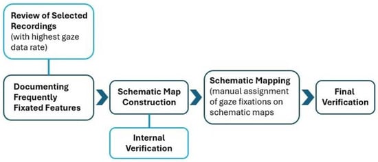
Figure 4.
Schematic mapping process for analyzing mobile eye-tracking data in complex interior environments.
3.6.2. Verbal Data Analysis
Think-aloud recordings were transcribed verbatim and thematically analyzed to uncover the “why” factors—reasons or triggers behind participants’ wayfinding decisions, often reflecting non-visible cognitive processes. Two researchers independently coded the transcripts, identifying recurring themes related to wayfinding experience, environmental perception, and emotional response. Discrepancies between coders were resolved through discussion, with final decisions confirmed in consultation with the principal investigator. Content analysis focused on references to environmental features, expressions of confidence or confusion, and reasoning behind navigational choices. Transcripts were temporally aligned with gaze recordings, allowing cross-referencing between verbal commentary and visual attention.
3.6.3. Navigational Pattern Analysis
Navigation paths were reconstructed from video recordings to identify common route choices, navigation errors, and hesitation points. Time-to-completion and number of navigation errors were recorded as behavioral measures.
3.7. Applying Findings in Wayfinding Design
The final stage of this study involved translating findings from the analysis into actionable wayfinding design strategies. The research team developed design proposals grounded in empirical evidence derived through the mixed-methods approach of this study. This phase focused on generating context-specific, research-informed strategies to guide future implementation, aligned with user needs and site constraints identified earlier in the study. The experiential digital twin of the building, created during the earlier phase of the study, was also used throughout the design process and in stakeholder communications.
4. Analysis and Findings
4.1. Spatial Context and Wayfinding Challenges
The spatial context analysis focused on the first and third floors, where the three counseling centers are located. The analysis revealed the interior environmental conditions likely to impair first-time visitors’ wayfinding performance, including corridor density, door redundancy, and minimal signage. These baseline conditions framed the interpretation of participants’ gaze patterns and navigation errors presented in subsequent sections. On a one-way trip from any of the building’s entrances to the main check-in office of the counseling centers, visitors encounter multiple corridor junctions and 15 or more doors, resulting in 20 to 30 potential decision points. At several points along the route, there are no hanging or wall-mounted signs to indicate general areas or room groupings, and the available signs are too small or positioned too far away to be legible. Although some visitors may bypass certain doors if previously briefed, the spatial layout itself offers little intuitive guidance, and signage is limited primarily to small plaques on or beside individual doors.
The building comprises 175 rooms and 223 interior doors, spread across three floors, and is accessible through five public entrances. It houses two counseling centers on the first floor and one affiliated trauma assessment center on the third floor, all of which share a single check-in office located in Room 119A. Vestibules and exterior doors were excluded from the room count, as were unlabeled storage or utility spaces. However, stairwell and elevator doors were included, as they are visually and functionally indistinguishable from room entries and act as potential visual distractors during navigation.
The first floor contains 66 rooms and 83 interior doors arranged in a dense, grid-like layout. Corridors form nested loops and multiple dead ends, producing a maze-like configuration that significantly impedes intuitive wayfinding. On a one-way trip from any entrance to the shared check-in office (119A in Figure 5), visitors encounter multiple corridor junctions and 15 or more visible doors, creating 20 to 30 potential decision points. Room number plaques are small and readable only at close range, while signage is minimal or entirely absent at key junctions. Several areas include unlabeled doors, stairwells, and mechanical spaces, which act as visual distractors—increasing cognitive load and contributing to navigational hesitation. The check-in office itself is tucked around a corner within a private office suite and is not visible until directly in front of the door.
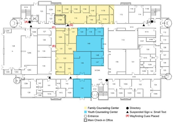
Figure 5.
First-floor plan of the current space, indicating three sectors used by two counseling centers. The rest of the first floor includes common areas and spaces for multiple academic departments. There are five building entrances.
Since visitors to the counseling centers are informed that the centers are located on the first and the third floors, the impact of the second-floor space on user experience is minimal. This floor includes 70 rooms with 89 doors and exhibits the same problematic grid pattern as the other floors, further compounding the building’s overall navigation challenges.
The third floor contains 39 rooms and 51 interior doors. While the building’s central open space on this level initially improves sightlines, this openness is deceptive—visitors must still traverse complex corridor branches and perimeter clusters to reach individual rooms. Linear arrangements of offices often terminate in dead ends, and the lack of progressive disclosure in signage or numbering undermines the initial sense of spatial clarity. As with the other floors, many unmarked doors and visually similar circulation features contribute to wayfinding distraction and confusion (Figure 6).
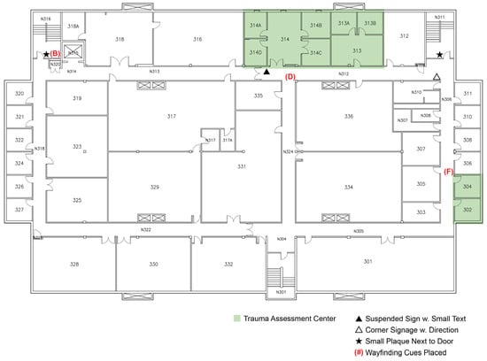
Figure 6.
Third-floor plan of current space, indicating two areas (in shades) used by a trauma assessment center. Four other college divisions are also located on the same floor.
Overall, visitors to any of the three centers suffer from a lack of wayfinding cues and their legibility, including signage, where the grid-patterned spatial arrangement and misplaced signs create confusion in visitors’ navigation. The shared check-in office location on the first floor compounds problems for visitors seeking services across multiple centers. With five building entrance points and no clear hierarchical circulation system, visitors face significant spatial disorientation regardless of their entry point or destination floor.
4.2. Gaze Behavior
The schematic mapping revealed recurrent fixation sequences at decision points, typically beginning with brief checks of structural elements (e.g., door/frame or corridor-ahead surfaces) and showing limited reliance on signage. Although heatmaps visualize overall distributions, all analyses and interpretations are grounded in the schematic mapping of mobile-video sequences, which captures sequence and spatial structure rather than AOI densities.
Participants’ gaze fixations revealed distinct patterns across the building areas. On the first floor, participants spent nearly 30% of their visual attention on doors and doorframes, while actual wayfinding aids, such as signage and room numbers, received less than 5% of fixations. Over 20% of gazes yielded no identifiable target (null gazes), suggesting unsuccessful visual searching. The third floor showed similar patterns, with doors and doorframes drawing 31% of fixations and walls receiving 40% of combined attention, while signage accounted for only 4% of visual focus. These distribution of features suggest that participants spent substantial effort scanning surfaces that provided minimal or no wayfinding value. While these distributions provide context, our analysis focuses on the sequential gaze patterns captured through schematic mapping.
Gaze patterns revealed mismatches between participants’ gaze behavior and the intended functions of signs. At one building entrance, participants’ fixation sequences revealed a problematic pattern: visual attention was first drawn to a wall-mounted sign referencing counseling centers, then shifted to an adjacent stairwell door, followed by repeated gaze transitions between the sign, door, and corridor ahead (Table 1. A). In some cases, this pattern resulted in short fixation cycles (e.g., sign → door → sign → hallway), suggesting uncertainty in interpreting whether the counseling centers were located through the nearby door or further ahead. Because the signage was positioned adjacent to the stairwell door without any directional clarification, the spatial association created an ambiguous or misleading visual cue. These fixation patterns highlight how poor alignment between signage placement and spatial configuration can generate visual confusion at the earliest stages of building entry.

Table 1.
Comparison of current spatial conditions and proposed wayfinding design interventions.
At key decision points, gaze sequences followed observable patterns. At T-intersections, participants alternated rapidly between left and right in search of directional information. At corridor corners, participants commonly looked at the corner walls, then the ceilings, floors, and finally the lateral walls. The finding that corner areas receive significant attention but provide no information represents missed opportunities for strategic signage placement. As they neared their destinations, gaze behavior often included repetitive scanning of doors, followed by checking room numbers, then backtracking and repeating this process. This occurred frequently, though not universally, across participants.
Our data show that inefficient gaze behaviors—particularly repeated scanning and fixations on non-informative surfaces (what we refer to as “null gazes”)—were common at points of spatial ambiguity. High rates of null gazes indicate cognitive overload and unsuccessful visual searching, emphasizing the need for more legible and salient wayfinding cues. Signs, whether wall-mounted or suspended, in areas with extended blank walls did not draw meaningful visual attention. Despite participants directing gaze fixations toward these signs, they failed to recognize the information content and continued searching, as evidenced in their think-aloud recordings.
These gaze behavior patterns corresponded with observable navigation difficulties. The high rates of null gazes and repeated scanning at decision points, combined with participants’ tendency to fixate on non-informative surfaces, were associated with the navigation errors described in the following section.
4.3. Navigation Behavior—Route Choices and Errors
Navigation behavior mirrored the ambiguities observed in the schematic gaze sequences. Immediately beyond one entrance vestibule, several participants hesitated after a brief fixation sequence that toggled between a wall-mounted sign referencing the counseling centers, the adjacent stairwell door, and the corridor ahead. In multiple cases, this culminated in a turn toward the stairwell before self-correction, indicating a misleading association between the sign and the nearby door when no directional cue was present.
Behavioral analysis (N = 24) showed pervasive wayfinding inefficiencies. Seventy-eight percent initially missed the reception area and doubled back. Sixty-five percent selected inefficient routes to Room 135 (e.g., turning left instead of right from reception). Eighty-three percent took the wrong direction when seeking Room 143, influenced by a discontinuity in the first-floor number sequence that suggested they had passed the destination. Ninety-one percent hesitated at a third-floor corridor intersection, and seventy-four percent experienced difficulty linking Rooms 304 and 314 despite belonging to the same center but residing in disconnected corridor branches.
Task duration reflected these challenges: mean 8:32 (SD 2:08), range 6:20–12:13. Longer times co-occurred with more frequent hesitations and negative affective remarks in think-aloud protocols.
4.4. Thematic Analysis of Think-Aloud Data
Thematic coding of the think-aloud transcripts (unitized by participant; N = 24) identified eight recurrent themes that contextualize the schematic mapping results. Percentages below indicate the proportion of participants whose transcripts contained the theme at least once.
4.4.1. Spatial Confusion from “Maze-like” Grid Layout and Missing Directional Cues
Participants consistently expressed uncertainty about navigation decisions, with most (87%) describing the building as confusing or maze-like. Many described the building as confusing or maze-like, lacking any discernible logic to guide decision-making. Comments such as “like a rat maze in here” and “have to guess which way to go” were typical. Several participants tried to use room numbers as orientation cues but found them misleading or difficult to follow: “numbers are getting bigger, so I thought I was going the wrong way.” The absence of intuitive spatial guidance or visual affordances left many relying on trial and error. As one participant put it, “everything just looks the same… there’s not a lot of leading hints.”
4.4.2. Visual Monotony from Uniform Configuration and Interior Elements
Most (83%) participants found that the uniform appearance of corridors impeded their ability to differentiate between spaces. Participants repeatedly remarked on the lack of variation in wall color, texture, and décor. Comments included, “everything is beige… even the paintings,” and “all the hallways look the same which is interesting.” The repetitive aesthetic contributed to disorientation, with several noting the environment felt “very bland… it all looks the same” or simply “boring, nothing to it.” This visual sameness undermined users’ ability to develop cognitive landmarks or remember route sequences.
4.4.3. Unwelcoming Atmosphere from Institutional Characteristics
Negative emotional responses to the environment were reported by 74% of participants. Several described the building as “sad,” “depressing,” or emotionally cold. Quotes included, “looks sad in here,” “depressing vibe,” and “it’s not super welcoming.” Some participants directly linked these impressions to their own affective state, suggesting that the emotional tone of the environment could amplify feelings of anxiety or discomfort. One participant reflected, “needs something a little more lively, it feels a little sad,” reinforcing the perceived lack of psychological support conveyed through the physical setting.
These negative emotional responses were further reinforced by participants’ spontaneous comparisons to institutional settings. Forty-three percent compared the building interior to old hospitals, while 22% referenced asylums, and 30% referred to elementary or middle schools. Nine percent likened it to a parking garage. These comparisons consistently carried negative connotations related to institutional, impersonal, uncomfortable, or intimidating environments, revealing the powerful impact of environmental aesthetics on emotional well-being. For mental health facilities, creating welcoming, non-institutional environments is particularly crucial given users’ potential vulnerability.
4.4.4. Outdated Design and Materiality
Temporal qualities of the space evoked negative associations. Many participants (70%) commented on worn finishes, dated fixtures, and an overall sense of obsolescence. Remarks included, “definitely outdated,” “really rundown… kind of old,” and “it looks like a really old doctor’s office.” These descriptors not only indicated aesthetic dissatisfaction but also implied diminished trust or confidence in the facility. One participant concluded bluntly, “it needs to be updated,” suggesting that the perceived age of the environment diminished its appropriateness for counseling functions.
4.4.5. Poor Lighting
About two-thirds of participants (65%) described the lighting conditions as problematic, calling the hallways dark and lacking natural light. Participants described the hallways as “very dark and dingy, not a lot of windows” and frequently mentioned the absence of natural light. One participant observed, “I just think the whole space is kind of scary and intimidating because of lack of natural light,” while another simply noted, “there’s no windows.” A common contrast emerged between the main corridors and stairwells, with multiple participants remarking, “it feels like it’s more lit in the stairwells than the actual hallways,” highlighting missed opportunities to improve comfort and legibility through lighting.
4.4.6. Narrow Corridors and Circulation Concerns
The constricted feel of corridors affected just over half (52%) of participants’ comfort and navigation. Participants frequently referenced the constricted feel of the corridors, expressing concern about visibility and circulation. Typical comments included, “halls feel narrow, if someone was coming around the corner you would run into them,” and “I don’t like how thin it feels, there’s not a lot of room.” Others described the corridors as “skinny,” and some associated the narrowness with negative emotional connotations, such as “it feels cold and closed off.” These remarks suggest that physical proportions were perceived as both functionally inadequate and psychologically uninviting.
4.4.7. Intimidating Environment from Sterile Appearance
Negative responses were common regarding the general atmosphere. Nearly half of participants (48%) described the building as eerie or intimidating, using language such as “creepy” or “scary.” Comments included, “it’s like a bunch of hallways that are creepy,” and “that is scary.” For some, the association between the space and counseling services intensified discomfort, as in the reflection, “I would be scared to come in here for a session.” Others made direct links to healthcare or institutional environments, saying it felt “kind of scary and intimidating, like a doctor’s office.”
4.4.8. Inadequate Signage at Decision Points
Most participants (91%) identified multiple signage deficiencies throughout the building. Many noted the complete absence of directional information at key junctions or decision points, relying instead on small room number plaques that were only legible at close range. Participants remarked, “there’s no signs so I can’t tell what it is,” and “the signs are very little.” Several expressed a desire for broader wayfinding support, stating, “it would be nice to have a sign saying which room numbers are which way,” and “other than the room numbers there isn’t much signage.” This lack of guidance was widely interpreted as a failure of environmental communication and a major source of cognitive strain.
5. From Empirical Insight to Design Intervention
Findings from empirical research can directly inform design methods and processes. Given the needs of the counseling centers and their clients, we developed research-based wayfinding design strategies that translate research findings into site-specific solutions that address challenges identified through this exploratory study. In developing wayfinding design strategies, the design team applied three fundamental principles: affordance, coherence, and legibility. Design constraints included limitations on physical alterations, such as uniform ceiling types and lighting fixtures throughout the building, inconsistent application of institutional colors, and the exclusion of two of the three academic departments sharing the building space from the scope of this project.
The following strategies address specific wayfinding barriers and emotional responses identified through eye tracking and verbal data analysis. These examples demonstrate how empirically measured visual attention patterns and verbal feedback can be translated into targeted design solutions that reduce cognitive load and address spatial confusion and visual inefficiency. The proposed solutions focus on developing coherent visual language and positive environmental connotations for wayfinding design, moving beyond problem-solving to create systematic visual communication.
5.1. Visual Hierarchy and Categorized Information
Based on the high incidence of null gazes and frequent hesitation at decision points, the design proposals incorporate comprehensive strategies to support both intuitive and signage-based wayfinding systems. To enhance intuitive wayfinding, the interventions create sequences of wayfinding cues that guide users’ visual attention toward key destinations while establishing clear entrances and exits through strategic nodes and zones reinforced by improved circulation routes (Table 1. A and B). The design removes inconsistent add-on elements that currently impair spatial legibility. Enhanced lighting at decision points and destinations improves visibility and creates a clearer spatial hierarchy. Clear visual communication with adequate legibility ensures that wayfinding information can be processed effectively by users under stress.
For signage-based wayfinding, the proposals establish clear directories with categorized information that follows logical organizational principles. This approach helps provide signage with sufficient information and strategic placement for users to quickly execute navigation decisions (Table 1. A and B). The visual logic and hierarchy incorporate elements that indicate different distances to destinations, while the directory organization follows a consistent top-down versus bottom-up numerical ordering to reduce cognitive load during information processing.
5.2. Spatial Identification Through Color Coding
Responding to 83% of participants who reported aesthetic monotony and lack of visual variation in corridors, the design assigns each counseling center a distinctive color palette that creates visual differentiation throughout the building. These color codes operate on multiple levels, distinguishing both floors and institutional units to provide clear spatial orientation. The color system integrates into directional signage at decision points, ensuring consistency between wayfinding information and spatial identity. Directional cues on the walls indicate routes and distances through color-coded directional lines, while coordinated color blocks around doors identify specific destinations and functional units (Table 1. E and F). This comprehensive color coding creates a clear visual language that supports both immediate navigation decisions and broader spatial comprehension.
5.3. Optimizing Signage Placement
Given that corner areas received significant visual attention but provided no wayfinding information, signage placement prioritizes locations where participants naturally directed their visual attention. Corner-mounted signs capitalize on high-fixation areas identified in the gaze behavior analysis, while ceiling-suspended directional signs with color coding ensure legibility from greater distances (Table 1. G). Enhanced room identification combines names and numbers to reduce the confusion observed when participants relied solely on numerical sequences. Signage and graphical cues incorporate selectively integrated seating or display areas that serve as landmarks (Table 1. C), providing memorable reference points for spatial orientation.
5.4. Spatial Differentiation and Landmarks
Addressing the finding that 74% of participants reported negative emotional responses and comparisons to institutional settings like hospitals and asylums, the design creates regions of differing visual characters through unique landmarks positioned at junction points throughout the building. These landmark features provide visitors with memorable orientation points and integrate wayfinding signage that presents directional cues at key decision points. The landmarks reinforce each center’s identity through distinct color branding while maintaining overall building coherence. Seating areas provide respite points that function as both wayfinding landmarks and user amenities, addressing the emotional comfort needs identified in the think-aloud analysis. The proposed wayfinding design features distinct color codes and geometric patterns that establish clear hierarchy among visual cues and create distinction between functional areas (Table 1. C–F), supporting orientation through distinctive spatial experiences that users can remember and reference during navigation. The overall approach balances coherence and distinction in environmental graphics to create a unified yet differentiated wayfinding system (Table 1. A–F). This comprehensive strategy establishes clear visual language and positive environmental connotations that support intuitive navigation while creating a more welcoming atmosphere for users.
6. Discussion
This study demonstrates the value of combining eye tracking with think-aloud protocols in wayfinding research, where each method compensates for the limitations of the other. The schematic mapping approach developed for data coding provides a replicable framework for analyzing mobile eye-tracking data in complex architectural environments where traditional AOI-based methods are unsuitable. The convergent evidence from gaze patterns, verbal protocols, and navigation patterns provides a more complete understanding of wayfinding challenges than any single method could achieve. This study did not involve inferential tests on AOI-style percentages because the data and claims concern mobile video sequences mapped schematically, not static-image areas; AOI shares in this context are compositional and not commensurate across participants without strong normalizations.
Rigor is supported through coder calibration and audit rather than AOI-based statistics. For completeness, the researchers evaluated software-assisted mapping, but without concurrent think-aloud data, it missed fine-grained fixation targets and sequence details in mobile video; results reported here rely on schematic mapping. While assisted mapping may scale in static or screen-based settings, its lack of verbal disambiguation and sensitivity to viewpoint/occlusion limited performance in mobile video; future work may revisit assisted mapping as tools mature.
Our methodological approach, integrating schematic mapping, yields interpretive clarity, cross-condition comparability, and actionable outputs for wayfinding design decisions (placement, hierarchy, materials). Its costs are procedural—time, coder training, and result cross-checks—not fundamental.
Several limitations constrain the generalizability of these findings. While participant demographics were limited to young adults from a single academic cohort, the schematic mapping approach for analyzing mobile eye-tracking data, when integrated with concurrent think-aloud data, is transferable to other institutional settings. Researchers evaluating wayfinding in hospitals, airports, or other complex buildings can adopt this methodology regardless of their specific user populations. This study examined only first-time visitors to one university building type. The limited organizational diversity, with the study conducted within a single institutional context housing specific types of counseling centers and academic departments, may affect the broader applicability of findings to other healthcare or institutional settings with different operational cultures and spatial arrangements. Additionally, the study focused exclusively on initial navigation experiences rather than examining how wayfinding strategies might change with repeated exposure to the environment.
Future research should include diverse age groups and abilities to better understand how wayfinding needs vary across populations. Comparative studies across different healthcare settings would help identify which findings are setting-specific versus more broadly applicable. Longitudinal research investigating changes in navigation behavior over time could reveal how users adapt their wayfinding strategies with familiarity. Post-occupancy evaluation of implemented design interventions would provide crucial evidence of the effectiveness of research-based wayfinding solutions and validate the proposed methodology.
This study employed an experiential digital twin for spatial and perceptual fidelity, prioritizing end-user experience, and used it to analyze the existing spatial context, test end-user wayfinding, and discuss materials applications and installation costs. This approach aligns with the fundamental values and principles of user-centered design, while operations-oriented digital twins, which focus on telemetry and supervisory control, lie outside this study’s scope.
7. Conclusions
This study establishes that wayfinding effectiveness in unfamiliar environments depends on both cognitive efficiency and emotional comfort, challenging traditional approaches that focus solely on functional navigation. By demonstrating measurable disconnects between user behavior and current environmental design, this research provides evidence that poor wayfinding systems compound stress for vulnerable populations seeking healthcare services.
This exploratory quasi-experimental study developed and demonstrated a transferable methodology for analyzing wayfinding challenges through convergent evidence from gaze patterns and verbal protocols. The integration of objective gaze data with subjective user experience reveals how environmental design decisions impact both navigation performance and psychological well-being, providing administrators and designers with actionable evidence for creating more supportive environments.
This study contributes a replicable framework for translating empirical research into evidence-based design practice, advancing the field’s capacity to create institutional environments that truly serve user needs rather than imposing generic solutions on complex spatial challenges.
Author Contributions
Conceptualization, Jain Kwon; methodology, Jain Kwon; formal analysis, Jain Kwon and Alea Schmidt; investigation, Jain Kwon, Alea Schmidt, Eunwoo Jun and Karina Martinez; writing—original draft preparation, Jain Kwon, Alea Schmidt and Chenyi Luo; writing—review and editing, Jain Kwon; visualization, Chenyi Luo; supervision, Jain Kwon; project administration, Jain Kwon; funding acquisition, Jain Kwon. All authors have read and agreed to the published version of the manuscript.
Funding
This research was funded by the ASID Foundation Irene Winifred Eno Grant.
Data Availability Statement
Data availability is conditional and requires case-by-case approval from all stakeholders, including participating healthcare providers.
Conflicts of Interest
The authors declare no conflicts of interest. The funders had no role in the design of the study; in the collection, analyses, or interpretation of data; in the writing of the manuscript; or in the decision to publish the results.
Abbreviations
The following abbreviations are used in this manuscript:
| AOI | Area of Interest |
| BIM | Building Information Modeling |
| BMS | Building Management System |
| IoT | Internet of Things |
| I-VT | Identification by Velocity Threshold |
References
- Arthur, P.; Passini, R. Wayfinding: People, Signs, and Architecture; McGraw-Hill: New York, NY, USA, 1992. [Google Scholar]
- Lynch, K. The Image of the City; MIT Press: Cambridge, MA, USA, 1960. [Google Scholar]
- König, P.; Wilming, N.; Kietzmann, T.C.; Ossandón, J.P.; Onat, S.; Ehinger, B.V.; Gameiro, R.R.; Kaspar, K. Eye Movements as a Window to Cognitive Processes. J. Eye Mov. Res. 2016, 9, 1–16. [Google Scholar] [CrossRef]
- Pati, D.; Harvey, T.E., Jr.; Willis, D.A.; Pati, S. Identifying elements of the health care environment that contribute to wayfinding. HERD Health Environ. Res. Des. J. 2015, 8, 44–67. [Google Scholar] [CrossRef] [PubMed]
- Spence, C. Multisensory design: Reaching out to touch the consumer. Psychol. Mark. 2020, 37, 1134–1142. [Google Scholar] [CrossRef]
- Lindsay, P.H.; Norman, D.A. Human Information Processing: An Introduction to Psychology, 2nd ed.; Academic Press: New York, NY, USA, 1977. [Google Scholar]
- Downs, R.M.; Stea, D. Maps in Minds: Reflections on Cognitive Mapping; Harper & Row: New York, NY, USA, 1977. [Google Scholar]
- Passini, R. Wayfinding design: Logic, application and some thoughts on universality. Des. Stud. 1996, 17, 319–331. [Google Scholar] [CrossRef]
- Kaplan, R.; Kaplan, S. The Experience of Nature: A Psychological Perspective; Cambridge University Press: Cambridge, UK, 1989. [Google Scholar]
- Stamps, A.E., III. Mystery, complexity, legibility and coherence: A meta-analysis. J. Environ. Psychol. 2004, 24, 1–16. [Google Scholar] [CrossRef]
- Gibson, J.J. The Ecological Approach to Visual Perception; Houghton Mifflin: Boston, MA, USA, 1979. [Google Scholar]
- Norman, D.A. The Psychology of Everyday Things; Basic Books: New York, NY, USA, 1988. [Google Scholar]
- O’Neill, M.J. Effects of signage and floor plan configuration on wayfinding accuracy. Environ. Behav. 1991, 23, 553–574. [Google Scholar] [CrossRef]
- Peponis, J.; Zimring, C.; Choi, Y.K. Finding the building in wayfinding. Environ. Behav. 1990, 22, 555–590. [Google Scholar] [CrossRef]
- Calori, C.; Vanden-Eynden, D. Signage and Wayfinding Design: A Complete Guide to Creating Environmental Graphic Design Systems; Wiley: Hoboken, NJ, USA, 2015. [Google Scholar]
- Vilar, E.; Rebelo, F.; Noriega, P.; Teles, J.; Mayhorn, C. The influence of environmental features on route selection in an emergency situation. Appl. Ergon. 2013, 44, 618–627. [Google Scholar] [CrossRef] [PubMed]
- Kwon, J. Cultural Meaning of Color in Healthcare Environments: A Symbolic Interaction Approach. Ph.D. Thesis, University Digital Conservancy, University of Minnesota, Minneapolis, MN, USA, 2010. Available online: https://hdl.handle.net/11299/92206 (accessed on 29 July 2025).
- Ishikawa, T.; Fujiwara, H.; Imai, O.; Okabe, A. Wayfinding with a GPS-based mobile navigation system: A comparison with maps and direct experience. J. Environ. Psychol. 2008, 28, 74–82. [Google Scholar] [CrossRef]
- Wiener, J.M.; Hölscher, C.; Büchner, S.J.; Konieczny, L. Gaze behavior during space perception and spatial decision making. J. Environ. Psychol. 2012, 76, 713–729. [Google Scholar] [CrossRef]
- Kiefer, P.; Giannopoulos, I.; Raubal, M. Where am I? Investigating map-matching during self-localization with mobile eye tracking in an urban environment. Trans. GIS 2014, 18, 660–686. [Google Scholar] [CrossRef]
- Kwon, J.; Kim, J.Y. Meaning of gaze behaviors in individuals’ perception and interpretation of commercial interior environments: An experimental phenomenology approach involving eye-tracking. Front. Psychol. 2021, 12, 581918. [Google Scholar] [CrossRef]
- Ulrich, R.S.; Zimring, C.; Zhu, X.; DuBose, J.; Seo, H.B.; Choi, Y.S.; Quan, X.; Joseph, A. A review of the research literature on evidence-based healthcare design. HERD Health Environ. Res. Des. J. 2008, 1, 61–125. [Google Scholar] [CrossRef]
- Huisman, E.R.C.M.; Morales, E.; van Hoof, J.; Kort, H.S.M. Healing environment: A review of the impact of physical environmental factors on users. Build. Environ. 2012, 58, 70–80. [Google Scholar] [CrossRef]
- Schmitz, S. Gender-related strategies in environmental development: Effects of anxiety on wayfinding in and representation of a three-dimensional maze. J. Environ. Psychol. 1997, 17, 215–228. [Google Scholar] [CrossRef]
- Zimring, C.; Joseph, A.; Choudhary, R. The Role of the Physical Environment in the Hospital of the 21st Century: A Once-in-a-Lifetime Opportunity; The Center for Health Design: Concord, CA, USA, 2005. [Google Scholar]
- Mousavi, Y.; Gharineiat, Z.; Karimi, A.A.; McDougall, K.; Rossi, A.; Gonizzi Barsanti, S. Digital twin technology in built environment: A review of applications, capabilities and challenges. Smart Cities 2024, 7, 2594–2615. [Google Scholar] [CrossRef]
- Grieves, M.; Vickers, J. Digital twin: Mitigating unpredictable, undesirable emergent behavior in complex systems. In Transdisciplinary Perspectives on Complex Systems; Springer: Berlin/Heidelberg, Germany, 2017; pp. 85–113. [Google Scholar]
- Horvath, A.S.; Pouliou, P. Digital twins in architecture: An ecology of practices and understandings. In Handbook of Digital Twins; Springer: Berlin/Heidelberg, Germany, 2024; pp. 662–686. [Google Scholar]
- Liu, W.; Lv, Y.; Wang, Q.; Sun, B.; Han, D. A systematic review of the digital twin technology in buildings, landscape and urban environment from 2018 to 2024. Buildings 2024, 14, 3475. [Google Scholar] [CrossRef]
- Kwon, J.; Linihan, S.; Iedema, A.; Schmidt, A.; Luo, C.; Marrufo, K. How interior design responds to neurodiversity: Implementing wearable technologies in neurodesign processes. Front. Built Environ. 2023, 9, 1211519. [Google Scholar] [CrossRef]
- Treedis. Digital Twin Studio Case Study: Indoor Navigation in Hospitality Buildings. Facilities Management Sector. 2024. Available online: https://www.treedis.com/case-studies/garni-hotel-indoor-navigation (accessed on 29 July 2025).
- Kemkomnerd, W.; Tirapas, C. The Digital Twin Immersive Design Process and Its Potential Disruption to Healthcare Design through a User-Centered Approach. Buildings 2024, 14, 2839. [Google Scholar] [CrossRef]
- Digital Twin Consortium. Definition of a Digital Twin. 2024 (Living Page). Available online: https://www.digitaltwinconsortium.org/initiatives/the-definition-of-a-digital-twin/ (accessed on 1 July 2025).
- The Institution of Engineering and Technology (IET). Digital Twins for the Built Environment; IET: London, UK, 2019; Available online: https://www.theiet.org/media/8762/digital-twins-for-the-built-environment.pdf (accessed on 1 July 2025).
- Bäcklund, K.; Andersson, M.; Karlsson, N.; Lundgren, R.; Palmquist, L. Showcasing a Digital Twin for Higher Educational Buildings: Developing the Concept toward Human Centricity. Front. Built Environ. 2024, 10, 1347451. [Google Scholar] [CrossRef]


Disclaimer/Publisher’s Note: The statements, opinions and data contained in all publications are solely those of the individual author(s) and contributor(s) and not of MDPI and/or the editor(s). MDPI and/or the editor(s) disclaim responsibility for any injury to people or property resulting from any ideas, methods, instructions or products referred to in the content. |
© 2025 by the authors. Published by MDPI on behalf of the International Society for Photogrammetry and Remote Sensing. Licensee MDPI, Basel, Switzerland. This article is an open access article distributed under the terms and conditions of the Creative Commons Attribution (CC BY) license (https://creativecommons.org/licenses/by/4.0/).