Next Issue
Volume 12, November
Previous Issue
Volume 12, September


Geosciences, Volume 12, Issue 10 (October 2022) – 40 articles

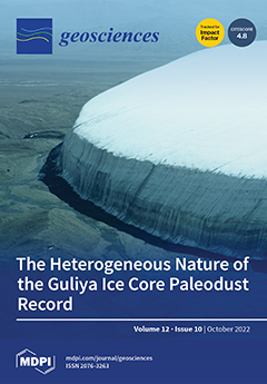
Cover Story (view full-size image): Compressed layers of paleo-aeolian dust are visible on the southern margin of the Guliya ice cap (western Kunlun Mountains, Tibet). This study is a physical, mineralogical, and geochemical characterization of dust particles from discrete deep sections of two Guliya ice cores, which provides a rare glimpse of the aeolian dust composition that predates the Last Glacial Maximum. The comparison between the deep layers of the Summit and Plateau sites and between stadial and interstadial transition layers of the Plateau core reveals the high variability of the Guliya dust record and demonstrates its value as an indicator of paleo-environmental conditions prevailing in NW Tibet since the Late Pleistocene. View this paper
  • Issues are regarded as officially published after their release is announced to the table of contents alert mailing list.
  • You may sign up for e-mail alerts to receive table of contents of newly released issues.
  • PDF is the official format for papers published in both, html and pdf forms. To view the papers in pdf format, click on the "PDF Full-text" link, and use the free Adobe Reader to open them.
Order results
Result details
Section
Select all
Export citation of selected articles as:
27 pages, 4219 KiB  
Article
Structurally Controlled Landscape Evolution in Kula Badlands, Western Turkey
by Selçuk Aksay, Jeroen M. Schoorl, Antonie Veldkamp, Tuncer Demir, Ahmet Serdar Aytaç and Darrel Maddy
Geosciences 2022, 12(10), 390; https://doi.org/10.3390/geosciences12100390 - 21 Oct 2022
Cited by 1 | Viewed by 2700
Abstract
Badlands are extensively eroded landscapes consisting of weakly consolidated deposits within highly dense drainage systems. Their controlling and shaping factors can differ in relation to various internal and external conditions and processes that are not always well understood. This study focuses on the [...] Read more.
Badlands are extensively eroded landscapes consisting of weakly consolidated deposits within highly dense drainage systems. Their controlling and shaping factors can differ in relation to various internal and external conditions and processes that are not always well understood. This study focuses on the development of a badland landscape affecting Miocene and Quaternary sand-clay sediments in the extensional tectonic regime of Western Turkey with a multidisciplinary approach. The area between Kula and Selendi towns exhibits a badland topography with extensively eroded surface features, deepened gullies within poorly consolidated, sand clay-sized sediments. The results of structural field mapping and morphometric analyses using a 5 m resolution DEM to study the role of structural control in the development of badlands are presented in this study. Field data analysis supported by the quantitative assessment of longitudinal gully profiles illustrates the role of pre-existing structures as faults, their orientation and geometry in net erosion-sedimentation and the development of deepened gully networks. Representative illustrations, field photographs and block diagrams are presented to show the relationship between the rock structure and badland landscape. The connection between the extensional tectonics, erosional dynamics and geomorphology point to a structurally-controlled landscape in the Kula badlands in Western Turkey. Full article
Show Figures

Figure 1

15 pages, 12919 KiB  
Article
Imaging Arctic Permafrost: Modeling for Choice of Geophysical Methods
by Igor Buddo, Natalya Misyurkeeva, Ivan Shelokhov, Evgeny Chuvilin, Alexey Chernikh and Alexander Smirnov
Geosciences 2022, 12(10), 389; https://doi.org/10.3390/geosciences12100389 - 21 Oct 2022
Cited by 7 | Viewed by 2670
Abstract
Knowledge of permafrost structure, with accumulations of free natural gas and gas hydrates, is indispensable for coping with spontaneous gas emission and other problems related to exploration and production drilling in Arctic petroleum provinces. The existing geophysical methods have different potentialities for imaging [...] Read more.
Knowledge of permafrost structure, with accumulations of free natural gas and gas hydrates, is indispensable for coping with spontaneous gas emission and other problems related to exploration and production drilling in Arctic petroleum provinces. The existing geophysical methods have different potentialities for imaging the permafrost base and geometry, vertical fluid conduits (permeable zones), taliks, gas pockets, and gas hydrate accumulations in the continental Arctic areas. The synthesis of data on cryological and geological conditions was the basis for a geophysical–geological model of northern West Siberia to a depth of 400 m, which includes modern permafrost, lenses of relict permafrost with hypothetical gas hydrates, and a permeable zone that may be a path for the migration of gas–water fluids. The model was used to model synthetic seismic, electrical resistivity tomography (ERT), and transient electromagnetic (TEM) data, thus testing the advantages and drawbacks of the three methods. Electrical resistivity tomography has insufficient penetration to resolve all features and can run only in the summer season. Seismic surveys have limitations in mapping fluid conduits, though they can image a horizontally layered structure in any season. Shallow transient electromagnetic (sTEM) soundings can image any type of features included into the geological model and work all year round. Thus, the best strategy is to use TEM surveys as the main method, combined with seismic and ERT data. Each specific method is chosen proceeding from economic viability and feasibility in the specific physiographic conditions of mountain and river systems. Full article
(This article belongs to the Special Issue Permafrost and Gas Hydrate Response to Ground Temperature Rising)
Show Figures

Figure 1

17 pages, 2350 KiB  
Article
Comparison of Geogases in Two Cenozoic Sedimentary Basins
by Gabriele M. Berberich and Martin B. Berberich
Geosciences 2022, 12(10), 388; https://doi.org/10.3390/geosciences12100388 - 19 Oct 2022
Cited by 4 | Viewed by 1770
Abstract
We investigated fault gases (helium, radon, CO2) in two seismically active Cenozoic sedimentary basins: (a) Meinweg (in 2015), at a tectonically quiescent horst structure in the Lower Rhine Embayment; and (b) Bodanrück (in 2012; Lake of Constance), in the Molasse Basin [...] Read more.
We investigated fault gases (helium, radon, CO2) in two seismically active Cenozoic sedimentary basins: (a) Meinweg (in 2015), at a tectonically quiescent horst structure in the Lower Rhine Embayment; and (b) Bodanrück (in 2012; Lake of Constance), in the Molasse Basin and part of the seismically active Freiburg–Bonndorf–Bodensee Fault Zone (FBBFZ). Both study areas were selected because recent “GeoBio-Interactions” findings showed that red wood ants (RWA) are biological indicators of otherwise undetected degassing systems. We combined presence/absence data of RWA nests, their spatial pattern analysis (prototype lines), seismicity and known tectonic settings with soil gas analyses (a total of 817 samples) to unveil geochemical anomalies related to tectonic developments unknown so far. Currently, Meinweg can be considered “no ants land” due to the very low background-level of geogas concentrations. Thus, anomalies (Rn-CO2) weakly trending in NE-SW extension direction emerged. This could probably indicate the onset of (re)activation of the NE-SW-trending (Variscan) structures or the development of new fractures as an aftershock process of the 1992 Roermond earthquake that occurred about 15 km to the west. Results at Bodanrück (three RWA clusters and two RWA-free corridors) revealed degassing patterns in NW-SE and NNE-SSW directions in the clusters corresponding to re-activated and recent strike-slip fault systems. No gas anomalies were found in RWA-free corridors. The RWA nest distribution was shown to be a valuable tool for identifying areas of even actively degassing spotty anomalies caused by macro- and microscale brittle deformation masked by sediment cover. Full article
(This article belongs to the Special Issue Geogases in Fault Zones)
Show Figures

Figure 1

14 pages, 1415 KiB  
Article
Elemental and K-Ar Isotopic Signatures of Glauconite/Celadonite Pellets from a Metallic Deposit of Missouri: Genetic Implications for the Local Deposits
by Norbert Clauer, I. Tonguç Uysal and Amélie Aubert
Geosciences 2022, 12(10), 387; https://doi.org/10.3390/geosciences12100387 - 19 Oct 2022
Cited by 2 | Viewed by 1715
Abstract
In the course of attempting to date the host rocks of Viburnum metal deposits from the US state of Missouri, the purpose was here a detailed examination and contribution of the constitutive minerals of glauconite-rich pellets to the isotopic dating of these deposits. [...] Read more.
In the course of attempting to date the host rocks of Viburnum metal deposits from the US state of Missouri, the purpose was here a detailed examination and contribution of the constitutive minerals of glauconite-rich pellets to the isotopic dating of these deposits. The glauconite pellets of Cambrian sediments hosting metal concentrates were dated here by the K-Ar method to complement earlier published Rb-Sr data. The study confirmed that the preparation and purification step of such glauconite pellets is especially critical with the need for a specific cleaning step to not only remove the detrital counterparts but also all Sr-rich components occurring as accessory minerals such as the carbonates, sulfates and oxides that apparently “contaminated” the Rb-Sr results. The K-Ar data and the previously released Rb-Sr results obtained on strictly the same glauconite-rich separates outline clear age discrepancies that can be summarized by higher, “older” K-Ar age data at about 440, 415 and 390 Ma, and lower, “younger” Rb-Sr data at about 400 and 370 Ma. The glauconite separates of most samples being apparently not contaminated by various detrital K-rich crystals, the two dating methods should have been affected similarly. The analytical dispersion seems, then, to result from a diagenetic event that affected the Rb-Sr system more than the K-Ar system by a plausible addition/subtraction of one or several Sr-rich and Rb-poor and, therefore, K-poor minerals. In turn, the studied pellets were apparently impregnated after deposition by flowing metal-rich fluids in a low-temperature environment not affected by a significant thermal impact. The Bonneterre Formation acted apparently as a regional drain for metal-rich fluids that percolated throughout the region at a probable burial depth of less than 2000 m. Full article
(This article belongs to the Topic Basin Analysis and Modelling)
Show Figures

Figure 1

18 pages, 8525 KiB  
Article
Tsunami Detection Model for Sea Level Measurement Devices
by Alessandro Annunziato
Geosciences 2022, 12(10), 386; https://doi.org/10.3390/geosciences12100386 - 18 Oct 2022
Cited by 1 | Viewed by 2687
Abstract
Sea level measurements are of critical importance in the verification of tsunami generation. When a large earthquake occurs in a subduction zone and the Regional Tsunami Service Providers of UNESCO/IOC issue alerts, sea level measurements are used to verify tsunami generation and take [...] Read more.
Sea level measurements are of critical importance in the verification of tsunami generation. When a large earthquake occurs in a subduction zone and the Regional Tsunami Service Providers of UNESCO/IOC issue alerts, sea level measurements are used to verify tsunami generation and take further actions (i.e., the evacuation of coastal areas). However, in some cases, if the tsunami source is very close to the coast, there is not enough time between the identification of an event and the issue of alerting bulletins. In addition, when the tsunami is not generated by a large earthquake but rather an atypical source (i.e., landslide or volcanic eruption) or prior information from the earthquake is not available before the arrival of the tsunami, it is of vital importance to have other means for the verification of tsunami generation. The algorithm presented in this paper, already installed in several operational devices, is capable of acquiring, processing and moving data back into the data server of the Joint Research Centre of the European Commission (EC-JRC) or any other relevant database; it can also be used for any sea level measurement of interest with corresponding triggering criteria. Full article
(This article belongs to the Special Issue Marine Geohazards)
Show Figures

Graphical abstract

25 pages, 21673 KiB  
Article
Back-Analysis of the Abbadia San Salvatore (Mt. Amiata, Italy) Debris Flow of 27–28 July 2019: An Integrated Multidisciplinary Approach to a Challenging Case Study
by Michele Amaddii, Giorgio Rosatti, Daniel Zugliani, Lorenzo Marzini and Leonardo Disperati
Geosciences 2022, 12(10), 385; https://doi.org/10.3390/geosciences12100385 - 17 Oct 2022
Cited by 4 | Viewed by 2929
Abstract
On 27–28 July 2019, in a catchment of the Mt. Amiata area (Italy), an extreme rainfall induced a debris flow, which caused a channeled erosive process just upstream of the Abbadia San Salvatore village, the obstruction of a culvert at the entrance to [...] Read more.
On 27–28 July 2019, in a catchment of the Mt. Amiata area (Italy), an extreme rainfall induced a debris flow, which caused a channeled erosive process just upstream of the Abbadia San Salvatore village, the obstruction of a culvert at the entrance to the urban area, and the subsequent flooding of the village. In this paper, we present the back analysis of this event. The complexity of this case study is due to several peculiar characteristics, but above all, to the clogging of the culvert, a phenomenon difficult to simulate numerically. The methodology used for the reconstruction of the event is based on a multidisciplinary approach. A geological field investigation was carried out to characterize the catchment and assess the availability of debris. Then, a cascade of numerical models was employed to reconstruct the debris flow: the FLO-2D software was used to model the runoff along the hydrographic network while the mobile-bed debris flow TRENT2D model, available through the WEEZARD system, was used to quantify both the erosion and deposition processes that occurred during the event. To simulate the culvert clogging, a novel modelling procedure was developed and applied. Despite the challenging framework, the results, in terms of debris volume, erosion rates, deposition area, and timing of the culvert obstruction, agree reasonably well with the observed data. It is worth noticing that these results were obtained mainly using parameters set a priori, namely calibrated on a physical basis. This proves that the proposed methodology is robust and effective, with good predictive capability. Therefore, it may be considered, according to the European Union (EU) Flood Directive, an “appropriate practice and the best available technology that does not imply excessive costs” to support predictive hazard mapping of situations as the one here considered. Full article
(This article belongs to the Special Issue Scientific Assessment of Recent Natural Hazard Events)
Show Figures

Figure 1

15 pages, 2439 KiB  
Article
Applying Factor Analysis and the CCME Water Quality Index for Assessing Groundwater Quality of an Aegean Island (Rhodes, Greece)
by Dimitrios E. Alexakis
Geosciences 2022, 12(10), 384; https://doi.org/10.3390/geosciences12100384 - 17 Oct 2022
Cited by 10 | Viewed by 2616
Abstract
Globally, water quality indices (WQIs) are beneficial for evaluating groundwater and surface water quality. The Canadian Council of Ministers of Environment Water Quality Index (CCME WQI) was combined with the parametric values given by Directive 98/83/EC to investigate the possible suitability of groundwater [...] Read more.
Globally, water quality indices (WQIs) are beneficial for evaluating groundwater and surface water quality. The Canadian Council of Ministers of Environment Water Quality Index (CCME WQI) was combined with the parametric values given by Directive 98/83/EC to investigate the possible suitability of groundwater resources for human consumption on Rhodes Island. Chloride (Cl), pH, calcium (Ca2+), electrical conductivity (CND), carbonate (CO32−), bicarbonate (HCO3), potassium (K+), magnesium (Mg2+), sulfate (SO42−), sodium (Na+),nitrate (NO3), nitrite (NO2), ammonium (NH4+), and phosphate (PO43−) were included in the dataset applied in this study. Statistical analysis, GIS database, and WQI estimation were successfully used to evaluate the groundwater resources of the study area. All studied groundwater parameters have mean and median values lower than the corresponding parametric values established by Directive 98/83/EC. The high CND values (up to 2730 μs cm−1) in groundwater collected from Rhodes’ coastal aquifers indicate a direct relationship with seawater intrusion. CCME-WQI classifies the groundwater samples for most monitoring stations on Rhodes aquifers as “excellent”, Class 5, for 2019 and 2020. The findings of this study may be helpful for scientists and stakeholders monitoring the study area and applying measures to protect the groundwater resources. Full article
Show Figures

Figure 1

25 pages, 8919 KiB  
Article
Assessment of Ground Instabilities’ Causative Factors Using Multivariate Statistical Analysis Methods: Case of the Coastal Region of Northwestern Rif, Morocco
by Haytam Tribak, Muriel Gasc-Barbier and Abdelkader El Garouani
Geosciences 2022, 12(10), 383; https://doi.org/10.3390/geosciences12100383 - 14 Oct 2022
Cited by 4 | Viewed by 2221
Abstract
An assessment of ground instabilities’ causative factors remains a topical subject. Such studies are rare, and evaluation techniques are still under development. The choice of evaluation technique should take into account the materials available and the objective sought. Statistical analysis methods are the [...] Read more.
An assessment of ground instabilities’ causative factors remains a topical subject. Such studies are rare, and evaluation techniques are still under development. The choice of evaluation technique should take into account the materials available and the objective sought. Statistical analysis methods are the most widely used, with multivariate analysis being the most accurate. The present work evaluates the weights of the influences of the different factors of ground instability of the coastal region between Tetouan and Jebha through multiple correspondence analysis (MCA) and principal component analysis (PCA). The application of both methods requires an accurate ground instability inventory with study sites that are well documented through modalities of causative factors and other descriptive data. The performed MCA shows that lithology has a significant influence on the type of existing instability. It also helped classify the instabilities into five distinct classes according to their modalities and specify the factors that differentiate the classes. The PCA shows that lithology is the most influential factor in landslides, contrary to rockfalls, where a variety of factors can be preponderant. Full article
(This article belongs to the Collection New Advances in Geotechnical Engineering)
Show Figures

Figure 1

16 pages, 7522 KiB  
Article
3D Bayesian Inversion of Potential Fields: The Quebec Oka Carbonatite Complex Case Study
by Daniele Sampietro, Martina Capponi and Gerardo Maurizio
Geosciences 2022, 12(10), 382; https://doi.org/10.3390/geosciences12100382 - 13 Oct 2022
Cited by 8 | Viewed by 2289
Abstract
Potential fields methods, based on the exploitation of gravity and magnetic fields, are among the most important methods to recover fundamental information on the Earth crust structure at global, regional and local scales. The bottleneck for this kind of geophysical methods is often [...] Read more.
Potential fields methods, based on the exploitation of gravity and magnetic fields, are among the most important methods to recover fundamental information on the Earth crust structure at global, regional and local scales. The bottleneck for this kind of geophysical methods is often represented by the development of ad-hoc techniques to fully exploit the available data. In fact, each different technique can observe the effect of a single property of the subsurface and when we want to estimate this property from the observed field (the so-called inverse problem), several problems such as non-uniqueness and instability arise. A possible solution to these problems consists in jointly inverting, in a consistent way, different observed fields, possibly also incorporating all the available geological constraints. In the current work, we present an innovative Bayesian algorithm aimed at performing a full 3D joint inversion of gravity and magnetic fields constrained by geological a-priori qualitative information. The algorithm is tested on a real-case scenario, namely, a local study to estimate a complete 3D model of the Oka carbonatite complex. This complex is a composite pluton in Quebec (Canada), important for mining operations related to critical raw material such as Niobium and other rare earth. This example shows the reliability of the developed inversion algorithm and gives hints on the fundamental role that potential fields can play in mining activities. Full article
Show Figures

Figure 1

31 pages, 11709 KiB  
Article
Spatio-Temporal Variations in the Geochemistry of Laguna Salada de Chiprana, NE Spain
by Connor Doyle, Juan Pablo Corella, Stefan Schröder, Harald Strauss, Thomas Bishop, Jonathan Yarwood and Blas Valero-Garcés
Geosciences 2022, 12(10), 381; https://doi.org/10.3390/geosciences12100381 - 13 Oct 2022
Viewed by 2015
Abstract
Hypersaline lakes are sensitive and increasingly threatened ecological and depositional environments that are host to a diverse spectrum of industrial services, natural resources, and environmental processes. Furthermore, they are also important repositories of high-resolution palaeoenvironmental information and are potentially key archives in the [...] Read more.
Hypersaline lakes are sensitive and increasingly threatened ecological and depositional environments that are host to a diverse spectrum of industrial services, natural resources, and environmental processes. Furthermore, they are also important repositories of high-resolution palaeoenvironmental information and are potentially key archives in the reconstruction of environmental, climatic conditions and past human impacts in areas where other such repositories may not be available. Many saline lakes are threatened by increased farming and irrigation practices and the effects of global warming. Geochemical XRF analyses of a transect of sediment cores from Laguna Salada de Chiprana, a permanent hypersaline lake in the Iberian Peninsula, provide insights into geochemical processes and palaeoenvironmental changes occurring at the site throughout the last 300–400 years. Key changes identified within the sequence are defined both from a spatial and temporal aspect and characterise the profundal and littoral sub-environments of the lake. Initially, the onset of a phase of widespread agriculture and irrigation in the region occurred in the late 16–17th century to ~1850AD and was associated with relative increases in lake levels. This was followed by decreasing lake levels between 1850 and 1950AD, likely associated with increasing evaporative processes and decreased irrigation returns to the lake, which also allowed for increased organic productivity in the profundal setting. This may have been associated with the transition of the site to a wetland-type setting, where biological processes were able to flourish in the shallower central depocentres of the lake. In sequence, the introduction of farm machinery and changing irrigation patterns occurred around 1950, causing small increases in lake levels, colonization by charophytes as well as increased organic productivity in the littoral setting, likely due to the establishment of suitable environments for biological processes to occur in the shallower margins of the lake when water levels rose. From this period to the present day, slow drawdown of the lake has occurred coupled with increasing management of the site by the regional government, leading to several phenomena. Evaporative processes are high throughout the lake; there are falling but highly variable water levels and there is a segmentation of organic productivity, whereby falling lake levels permit increased organic productivity in the profundal setting but decrease productivity in the littoral setting due to the establishment of harsh evaporitic and erosive conditions in this area. The reconstruction reveals the high sensitivity of Lake Chiprana as an environmental archive and illustrates the need to utilise multiple sediment cores for accurate palaeoenvironmental reconstructions of saline lakes due to the strong variability in depositional and geochemical sub-environments. Full article
Show Figures

Figure 1

15 pages, 3743 KiB  
Article
Stability Analysis of Lava Tunnels on Santa Cruz Island (Galapagos Islands, Ecuador) Using Rock Mass Classifications: Empirical Approach and Numerical Modeling
by Gilmar Bastidas, Oliver Soria, Maurizio Mulas, Silvia Loaiza and Luis Jordá Bordehore
Geosciences 2022, 12(10), 380; https://doi.org/10.3390/geosciences12100380 - 12 Oct 2022
Cited by 10 | Viewed by 2309
Abstract
The cavities or lava tubes in the Galapagos Islands were formed by the differential cooling of the basaltic flow of the volcanoes surrounding these islands. In this article, a stability analysis was carried out to determine the degree of safety of different lava [...] Read more.
The cavities or lava tubes in the Galapagos Islands were formed by the differential cooling of the basaltic flow of the volcanoes surrounding these islands. In this article, a stability analysis was carried out to determine the degree of safety of different lava tubes using three methods: two empirical ones based on geomechanical classifications and one strain–strain (Hoek–Brown failure criterion). The methodology used consisted of the following phases: (i) compilation of information based on existing geomechanical mapping; (ii) geomechanical classification of the rock mass using Barton’s Q index and rock mass rating; (iii) steady state qualification using the geotechnical index of cavities (GCI); (iv) numerical modeling applying the Hoek–Brown criterion; (v) comparison of methodology and discussion of the results. The data obtained indicate that the methodologies used to evaluate the stability of the lava tubes have high reliability since they allowed the characterization of the different lava tubes. As the final “product” of the investigation, a graph was drawn up in which the empirical observations and the safety factors obtained with the numerical analysis (stress–strain) were superimposed, classifying the lava tubes as stable and non-stable. It can be concluded that the characterization methodologies used in this article can be applied to similar cases and fill a gap in rapid preliminary analyses of the degree of stability and risk of cave collapse. Full article
(This article belongs to the Collection New Advances in Geotechnical Engineering)
Show Figures

Figure 1

11 pages, 3065 KiB  
Article
Theoretical Investigation Applied to Scattering Water Waves by Rectangular Submerged Obstacles/and Submarine Trenches
by Mohammed Loukili, Denys Dutykh, Sandrine Pincemin, Kamila Kotrasova and Nizar Abcha
Geosciences 2022, 12(10), 379; https://doi.org/10.3390/geosciences12100379 - 11 Oct 2022
Cited by 2 | Viewed by 2140
Abstract
A simple analytical model is presented in this work to investigate reflection coefficients due to the interactions of waves with rectangular submerged obstacles/and submarine trenches. Our intention in this work is to present a simple analytical model to simulate and study water-wave scattering [...] Read more.
A simple analytical model is presented in this work to investigate reflection coefficients due to the interactions of waves with rectangular submerged obstacles/and submarine trenches. Our intention in this work is to present a simple analytical model to simulate and study water-wave scattering by evaluating reflection coefficients. Further, our challenge is to present an analytical model that can easily investigate simultaneously the effects of rectangular submerged obstacles/and submarine trenches on wave scattering. Furthermore, reflection coefficients are investigated for different immersion ratios and relative lengths simultaneously for submarine trenches/and rectangular submerged obstacles. In addition, to ensure the validity of the presented model, our results are well compared with those of the literature. Finally, a comparison of reflection coefficients associated with the interactions of waves with rectangular submerged obstacles/and submarine trenches are presented to investigate the most efficient breakwater, and to highlight the importance of the presented model. Full article
(This article belongs to the Special Issue Interdisciplinary Geosciences Perspectives of Tsunami Volume 4)
Show Figures

Figure 1

20 pages, 8902 KiB  
Article
Use of High-Resolution Multi-Temporal DEM Data for Landslide Detection
by Behnam Azmoon, Aynaz Biniyaz and Zhen Liu
Geosciences 2022, 12(10), 378; https://doi.org/10.3390/geosciences12100378 - 11 Oct 2022
Cited by 10 | Viewed by 3250
Abstract
Landslides in urban areas have been relatively well-documented in landslide inventories despite issues in accuracy and completeness, e.g., the absence of small landslides. By contrast, less attention has been paid to landslides in sparsely populated areas in terms of their occurrences and locations. [...] Read more.
Landslides in urban areas have been relatively well-documented in landslide inventories despite issues in accuracy and completeness, e.g., the absence of small landslides. By contrast, less attention has been paid to landslides in sparsely populated areas in terms of their occurrences and locations. This study utilizes high-resolution and LiDAR-derived digital elevation models (DEMs) at two different times for landslide detection to (1) improve the localization and detection accuracies in landslide inventories, (2) minimize human intervention in the landslide detection process, and (3) identify landslides that cannot be easily documented in the current state of the practice. To achieve this goal, multiple preprocessing steps were used to ensure the spatial alignment of the multi-temporal DEMs. Map algebra was then used to calculate the vertical displacement for each cell and create a DEM of Difference (DoD) to obtain a quantitative estimation of ground deformations. Next, the elevation changes were filtered via an appropriate Level of Detection (LoD) threshold to mark potential landslide candidates. The landslide candidates were further assessed with the aid of customized topographic maps as auxiliary data and pattern recognition to distinguish landslides (true positive changes) from construction, erosion, and deposition (false positives). The results from the proposed method were compared with existing landslide inventories and reports to evaluate its performance. The new method was also validated with temporal high-resolution Google Earth images. The results showed the successful application of the method in landslide detection and mapping. Compared with traditional methods, the proposed method provides a semi-automatic way to obtain landslide inventories with publicly available yet lowly utilized DEM data, which can be valuable in preliminary analysis for landslide detection. Full article
(This article belongs to the Collection New Advances in Geotechnical Engineering)
Show Figures

Figure 1

19 pages, 8368 KiB  
Article
Magnetic Anomalies of the Tyrrhenian Sea Revisited: A Processing Workflow for Enhancing the Resolution of Aeromagnetic Data
by Giovanni Florio, Salvatore Passaro, Giovanni de Alteriis and Federico Cella
Geosciences 2022, 12(10), 377; https://doi.org/10.3390/geosciences12100377 - 10 Oct 2022
Cited by 5 | Viewed by 2172
Abstract
We propose a processing workflow to enhance the information content of aeromagnetic data. Our workflow is based on the downward continuation and subsequent L-transform of magnetic data. This workflow returns a map showing single highs, which correspond to the location of magnetic [...] Read more.
We propose a processing workflow to enhance the information content of aeromagnetic data. Our workflow is based on the downward continuation and subsequent L-transform of magnetic data. This workflow returns a map showing single highs, which correspond to the location of magnetic bodies, and does not need any a priori information about the source magnetization. We validated our workflow using the aeromagnetic anomalies of the Tyrrhenian Sea (Italy), by a comparison of the reprocessed aeromagnetic anomalies with high-resolution shipborne magnetic data in three selected areas. Through this comparison, we show that the proposed processing workflow of aeromagnetic data leads to more accurate interpretative results. Our results indicate that, in areas where higher resolution data are lacking, the reprocessing of aeromagnetic data according to our workflow may be as decisive as to suggest changes to their previous interpretations or, at least, useful for highlighting areas of special interest, deserving to be magnetically explored by a dedicated high-resolution shipborne survey. Full article
Show Figures

Figure 1

17 pages, 3212 KiB  
Article
A First Simulation of the Impact upon the Hidroagoyán Dam Due to Lahars Triggered by an 1877-Type Cotopaxi Eruption in Ecuador
by Francesco Chidichimo, Paolo Catelan, Valeria Lupiano, Salvatore Straface and Salvatore Di Gregorio
Geosciences 2022, 12(10), 376; https://doi.org/10.3390/geosciences12100376 - 10 Oct 2022
Viewed by 2118
Abstract
We forecast the impact that the lahars triggered on the summit of the Cotopaxi volcano in Ecuador would have upon the Hidroagoyán Dam should an 1877-type catastrophic eruption occur nowadays, with disastrous implications for the energy production of Ecuador. The Cotopaxi’ lahars have [...] Read more.
We forecast the impact that the lahars triggered on the summit of the Cotopaxi volcano in Ecuador would have upon the Hidroagoyán Dam should an 1877-type catastrophic eruption occur nowadays, with disastrous implications for the energy production of Ecuador. The Cotopaxi’ lahars have been simulated with the use of different computational models, yet none of them were so extended as to map their entire path to the dam. To fill this gap, we applied a version of the semi-empirical Cellular Automata LLUNPIY model to simulate primary and secondary lahars flowing from the summit of the Cotopaxi volcano until they reach the Hidroagoyán Dam in Baños. This version of LLUNPIY accounts for the triggering event by pyroclastic bombs and has already been validated by its successful simulation of the northbound 1877 cataclysmic lahars of the Cotopaxi volcano. The likely consequences of a similar disaster are discussed considering present territorial conditions. Computer simulations of natural hazards of this type represent a powerful tool that can be used when planning for the mitigation of environmental and social risks. Full article
(This article belongs to the Section Natural Hazards)
Show Figures

Figure 1

24 pages, 7181 KiB  
Article
Stratigraphic Modelling of the Lower/Middle Oxfordian (Upper Jurassic) Outer Ramp Deposits from the NE Paris Basin (France)
by Chloé Morales, Pierre Pellenard, Benoit Vincent, Franck Smektala, Fleur Daniau and Philippe Landrein
Geosciences 2022, 12(10), 375; https://doi.org/10.3390/geosciences12100375 - 10 Oct 2022
Viewed by 2529
Abstract
We investigate herein the lateral and vertical lithological heterogeneities of the Lower/Middle Oxfordian deposits (“Terrain à Chailles” and “Marnes des Eparges” formations) in the north-eastern Paris Basin. This new detailed stratigraphic framework documents the evolution at high resolution of an outer ramp based [...] Read more.
We investigate herein the lateral and vertical lithological heterogeneities of the Lower/Middle Oxfordian deposits (“Terrain à Chailles” and “Marnes des Eparges” formations) in the north-eastern Paris Basin. This new detailed stratigraphic framework documents the evolution at high resolution of an outer ramp based on regional correlations in order to constrain the evolution of petrological properties between the clayey “Argiles de la Woëvre” Formation and the more calcareous “Marnes et Calcaires à Coraux de Foug Formation. The “Argiles de la Woëvre” Formation is targeted for the deep storage of nuclear waste in north-eastern France. Nine wells are correlated over the “Zone of Interest for Further Research” (ZIRA), defined by the French agency for radioactive waste management (Andra), with a resolution of 0.5–1.0 m. The architecture and the age control of these formations have been refined, revealing that the “Terrain à Chailles” Formation is characterised by a regular slightly inclined sedimentation gently deeping in the SW direction and shows a lithological evolution from silty claystones to an increased occurrence of its calcareous content towards the top (Lower Oxfordian, uppermost mariae and cordatum ammonite zones). The above “Marnes des Eparges” Formation, characterised by claystone limestone alternations, is assigned to the Middle Oxfordian (plicatilis ammonite zone), deposited during a slightly enhanced subsidence phase in the SE part of the basin and documented and associated with onlaps geometries on the more proximal areas. However, this change in geometry does not affect petrological properties over ZIRA, as this is not accompanied by lithological changes. The environmental factors controlling petrological heterogeneities over ZIRA are also discussed. The stepwise increase in the carbonate content and the decrease in the detrital content towards the Lower to Middle Oxfordian deposits was likely triggered by a climate change towards drier conditions, modulated by sea level changes on a ramp morphology. A major condensation phase encompassing most of the Lower Oxfordian cordatum ammonite zone is also highlighted. The occurrence of a maximum regressive surface associated with gentle slope topography is a probable trigger for condensation. Changes in geometries are, however, associated with the activity of the Metz Fault, which potentially had an influence on the subsidence rates of the basin at that time. Full article
(This article belongs to the Special Issue Jurassic Paleoenvironments)
Show Figures

Figure 1

15 pages, 4565 KiB  
Article
A Reappraisal of the Destructive Earthquake (Mw5.9) of 15 July 1909 in Western Greece
by Ioanna Triantafyllou, Ioannis Koukouvelas, Gerassimos A. Papadopoulos and Efthymios Lekkas
Geosciences 2022, 12(10), 374; https://doi.org/10.3390/geosciences12100374 - 10 Oct 2022
Cited by 4 | Viewed by 2341
Abstract
Studies on earthquakes that occurred in the early instrumental period of seismology are of importance for the seismic hazard assessment and are still under investigation since new data are being increasingly revealed. We study the case of a moderate-to-strong earthquake that occurred on [...] Read more.
Studies on earthquakes that occurred in the early instrumental period of seismology are of importance for the seismic hazard assessment and are still under investigation since new data are being increasingly revealed. We study the case of a moderate-to-strong earthquake that occurred on 15 July 1909 in NW Peloponnese, Greece. Although the earthquake event was quite destructive, it remains little-known so far in the seismological tradition. We compiled a variety of documentary sources and showed that the earthquake caused extensive building destruction in Chavari and in many other villages with an estimated maximum intensity IX (in EMS-98 scale) and a death toll as high as 55. We also assigned macroseismic intensities in several observation points and drew isoseismal lines by applying the nearest-neighbor technique. From empirical relationships between magnitude and intensities, we estimated the macroseismic magnitude of proxy Ms5.9. Our examination also revealed a variety of earthquake associated phenomena including several types of precursors and abundant co-seismic hydrological changes and ground failures, such as soil liquefaction, surface ruptures, and rock falls. Since no surface fault-trace was reported, the determination of the causative blind fault remains an open issue for future investigation. Full article
(This article belongs to the Special Issue Modern Perspectives in Historical Seismology)
Show Figures

Figure 1

14 pages, 10796 KiB  
Article
Study of Micro-Parameters of DEM Model on the Laboratory Experiment Results Obtained from Poorly Cemented Sandstone
by Jun Hyuk Heo, Sam S. Hashemi and Noune Melkoumian
Geosciences 2022, 12(10), 373; https://doi.org/10.3390/geosciences12100373 - 9 Oct 2022
Cited by 1 | Viewed by 1698
Abstract
Borehole convergence during or after drilling is one of the primary indicators of borehole instability. Early recognition of borehole instability is critical in achieving successful and timely completion of drilling operations and for borehole exploitation. A series of numerical simulations was conducted to [...] Read more.
Borehole convergence during or after drilling is one of the primary indicators of borehole instability. Early recognition of borehole instability is critical in achieving successful and timely completion of drilling operations and for borehole exploitation. A series of numerical simulations was conducted to investigate the borehole convergence of poorly cemented sandstones using the Discrete Element Method (DEM). Rectangular 2-dimensional Particle Flow Code 2D (PFC2D) models were generated to study the effect of contributing micro-parameters such as stiffness ratio, friction angle, friction coefficient and effective modulus on the behaviour of poorly cemented sandstone subjected to triaxial compression tests. A good agreement between the calibrated numerical models and the experimental data obtained from the laboratory was observed. The results showed that the stiffness ratio was found to be a dominant factor in calibrating the numerical model, and the friction coefficient was the most influential micro-parameter. Full article
(This article belongs to the Section Geomechanics)
Show Figures

Figure 1

17 pages, 7193 KiB  
Article
Trigger Mechanisms of Gas Hydrate Decomposition, Methane Emissions, and Glacier Breakups in Polar Regions as a Result of Tectonic Wave Deformation
by Leopold I. Lobkovsky, Alexey A. Baranov, Mukamay M. Ramazanov, Irina S. Vladimirova, Yurii V. Gabsatarov, Igor P. Semiletov and Dmitry A. Alekseev
Geosciences 2022, 12(10), 372; https://doi.org/10.3390/geosciences12100372 - 8 Oct 2022
Cited by 17 | Viewed by 4882
Abstract
Trigger mechanisms are proposed for gas hydrate decomposition, methane emissions, and glacier collapse in polar regions. These mechanisms are due to tectonic deformation waves in the lithosphere–asthenosphere system, caused by large earthquakes in subduction zones, located near the polar regions: the Aleutian arc, [...] Read more.
Trigger mechanisms are proposed for gas hydrate decomposition, methane emissions, and glacier collapse in polar regions. These mechanisms are due to tectonic deformation waves in the lithosphere–asthenosphere system, caused by large earthquakes in subduction zones, located near the polar regions: the Aleutian arc, closest to the Arctic, and the Antarctica–Chilean and Tonga–Kermadec–Macquarie subduction zones. Disturbances of the lithosphere are transmitted over long distances (of the order of 2000–3000 km and more) at a speed of about 100 km/year. Additional stresses associated with them come to the Arctic and Antarctica several decades after the occurrence of seismic events. On the Arctic shelf, additional stresses destroy the microstructure of metastable gas hydrates located in frozen rocks at shallow depths, releasing the methane trapped in them and leading to filtration and emissions. In West Antarctica, these wave stresses lead to decreases in the adhesions of the covered glaciers with underlying bedrock, sharp accelerations of their sliding into the sea, and fault occurrences, reducing pressure on the underlying rocks containing gas hydrates, which leads to their decomposition and methane emissions. Full article
(This article belongs to the Special Issue Permafrost and Gas Hydrate Response to Ground Temperature Rising)
Show Figures

Figure 1

22 pages, 5995 KiB  
Article
Variable Response in Alpine Tree-Ring Stable Isotopes Following Volcanic Eruptions in the Tropics and Iceland
by Tito Arosio, Stéphane Affolter, Kurt Nicolussi, Michael Sigl, Malin Michelle Ziehmer-Wenz, Christian Schlüchter, Emmanuel Schaad, Rafael Stähli and Markus Christian Leuenberger
Geosciences 2022, 12(10), 371; https://doi.org/10.3390/geosciences12100371 - 8 Oct 2022
Cited by 2 | Viewed by 2319
Abstract
The importance of the stable isotopes in tree rings for the study of the climate variations caused by volcanic eruptions is still unclear. We studied δ18O, δD, δ13C stable isotopes of larch and cembran pine cellulose around four major [...] Read more.
The importance of the stable isotopes in tree rings for the study of the climate variations caused by volcanic eruptions is still unclear. We studied δ18O, δD, δ13C stable isotopes of larch and cembran pine cellulose around four major eruptions with annual resolution, along with a superposed epoch analysis of 34 eruptions with 5-year resolution. Initial analysis of the tropical Tambora (1815 CE) and Samalas (1257 CE) eruptions showed a post-eruption decrease in δ18O values attributed to post-volcanic cooling and increased summer precipitation in Southern Europe, as documented by observations and climate simulations. The post-volcanic cooling was captured by the δD of speleothem fluid inclusion. The δ18O decrease was also observed in the analysis of 34 major tropical eruptions over the last 2000 years. In contrast, the eruptions of c. 750, 756, and 764 CE attributed to Icelandic volcanoes left no significant responses in the cellulose isotopes. Further analysis of all major Icelandic eruptions in the last 2000 years showed no consistent isotopic fingerprints, with the exception of lower post-volcanic δ13C values in larch. In summary, the δ18O values of cellulose can provide relevant information on climatic and hydroclimatic variations following major tropical volcanic eruptions, even when using the 5-year resolution wood samples of the Alpine Tree-Ring Isotope Record database. Full article
(This article belongs to the Section Climate)
Show Figures

Figure 1

24 pages, 21607 KiB  
Article
Using Mixed Reality for the Visualization and Dissemination of Complex 3D Models in Geosciences—Application to the Montserrat Massif (Spain)
by Marc Janeras, Joan Roca, Josep A. Gili, Oriol Pedraza, Gerald Magnusson, M. Amparo Núñez-Andrés and Kathryn Franklin
Geosciences 2022, 12(10), 370; https://doi.org/10.3390/geosciences12100370 - 7 Oct 2022
Cited by 7 | Viewed by 2739
Abstract
In the last two decades, both the amount and quality of geoinformation in the geosciences field have improved substantially due to the increasingly more widespread use of techniques such as Laser Scanning (LiDAR), digital photogrammetry, unmanned aerial vehicles, geophysical reconnaissance (seismic, electrical, geomagnetic), [...] Read more.
In the last two decades, both the amount and quality of geoinformation in the geosciences field have improved substantially due to the increasingly more widespread use of techniques such as Laser Scanning (LiDAR), digital photogrammetry, unmanned aerial vehicles, geophysical reconnaissance (seismic, electrical, geomagnetic), and ground-penetrating radar (GPR), among others. Furthermore, the advances in computing, storage and visualization resources allow the acquisition of 3D terrain models (surface and underground) with unprecedented ease and versatility. However, despite these scientific and technical developments, it is still a common practice to simplify the 3D data in 2D static images, losing part of its communicative potential. The objective of this paper is to demonstrate the possibilities of extended reality (XR) for communication and sharing of 3D geoinformation in the field of geosciences. A brief review of the different variants within XR is followed by the presentation of the design and functionalities of headset-type mixed reality (MR) devices, which allow the 3D models to be investigated collaboratively by several users in the office environment. The specific focus is on the functionalities of Microsoft’s HoloLens 2 untethered holographic head mounted display (HMD), and the ADA Platform App by Clirio, which is used to manage model viewing with the HMD. We demonstrate the capabilities of MR for the visualization and dissemination of complex 3D information in geosciences in data rich and self-directed immersive environment, through selected 3D models (most of them of the Montserrat massif). Finally, we highlight the educational possibilities of MR technology. Today MR has an incipient and reduced use; we hope that it will gain popularity as the barriers of entry become lower. Full article
(This article belongs to the Section Natural Hazards)
Show Figures

Figure 1

20 pages, 3902 KiB  
Article
Understanding Sediment Dynamics at a Shipwreck Site Using CFD Modelling
by Gary Littler, Mark Coughlan, Jan Majcher and Jennifer Keenahan
Geosciences 2022, 12(10), 369; https://doi.org/10.3390/geosciences12100369 - 7 Oct 2022
Viewed by 2693
Abstract
Shipwrecks are important cultural heritage sites offshore. In many instances, given their often long-term emplacement on the seafloor, they offer natural laboratories to study complex interactions between human-induced obstacles and seabed dynamics. Such interactions and induced sediment mobility also pose significant threats to [...] Read more.
Shipwrecks are important cultural heritage sites offshore. In many instances, given their often long-term emplacement on the seafloor, they offer natural laboratories to study complex interactions between human-induced obstacles and seabed dynamics. Such interactions and induced sediment mobility also pose significant threats to offshore engineering infrastructure, such as turbine monopile foundations. Traditional methods can struggle to capture the nuance of these processes, with real-world surveys measuring effects only after installation, and laboratory models suffering from scale-down inaccuracies. Computational fluid dynamics (CFD) modelling offers an effective means of investigating the effects of obstacles on seabed dynamics, and by using shipwrecks as proxies for infrastructure, it can utilize long-term datasets to verify its predictions. In this study, high-resolution temporal bathymetric data were used in, and to verify, CFD modelling to investigate the interactions between hydro- and sediment dynamics at a shipwreck site in a tidally dominated wreck site. From this comparison, simulations of bed shear stress and scalar transport correlate well with known areas of erosion and deposition, serving as a basis for future scour prediction studies and creating effective tools in offshore renewable infrastructure planning and de-risking. Full article
(This article belongs to the Special Issue Civil Structural Health Monitoring under Natural Hazards)
Show Figures

Figure 1

13 pages, 11140 KiB  
Article
Exploiting Ground-Penetrating Radar Signal Enhancements by Water-Saturated Bulb Surrounding Defective Waterpipes for Leak Detection
by Pierre Carrive, Albane Saintenoy, Emmanuel Léger, Steven A. Arcone and Pascal Sailhac
Geosciences 2022, 12(10), 368; https://doi.org/10.3390/geosciences12100368 - 4 Oct 2022
Cited by 3 | Viewed by 2682
Abstract
The detection of water leakage along its transportation network has important societal impacts, such as avoiding a large volume of water wasted along the waterways or preventing water-related chemical or physical surrounding media deterioration. Among the vast domain of destructive techniques, Ground-Penetrating Radar [...] Read more.
The detection of water leakage along its transportation network has important societal impacts, such as avoiding a large volume of water wasted along the waterways or preventing water-related chemical or physical surrounding media deterioration. Among the vast domain of destructive techniques, Ground-Penetrating Radar (GPR) is a common and efficient tool used for detection in many near-surface contexts, and it is particularly efficient in civil engineering cases, such as utility detection, due to its fine resolution and the ease of data acquisition. A peculiar form of signal enhancement appears in GPR profiles recorded over spheres and cylinders where velocity contrasts exist between the body’s material and the surrounding medium. We used this enhancement to detect potential water leakages in water pipes. After exhibiting the signal enhancement effect in a laboratory sandbox experiment using a spherical glass ball, we verified the results with numerical experiments with varied sphere and cylinder sizes and dielectric properties. We then investigated field and numerical experiments of GPR transects above a “real life” water-leaking PVC pipe. Our results show that the water cylinder and water infiltration bulb produced a characteristic signal that could be used for detecting water leakages along water pipes. The largest amplitude in the GPR signal is caused by a bottom pipe reflection enhanced by the water bulb and not by the top of the pipe. We stress the risk of miscalculating the pipe’s depth during velocity estimation when amplitude enhancement conditions are met. Beyond civil-engineering impacts, knowledge on signal amplification phenomena can help GPR data interpretations in sedimentology and hydrogeology studies. Full article
(This article belongs to the Special Issue Ground Penetrating Radar Velocities)
Show Figures

Figure 1

15 pages, 7121 KiB  
Article
Soil Loss Potential Assessment for Natural and Post-Fire Conditions in Evia Island, Greece
by Kanella Valkanou, Efthimios Karymbalis, George Bathrellos, Hariklia Skilodimou, Konstantinos Tsanakas, Dimitris Papanastassiou and Kalliopi Gaki-Papanastassiou
Geosciences 2022, 12(10), 367; https://doi.org/10.3390/geosciences12100367 - 1 Oct 2022
Cited by 15 | Viewed by 3027
Abstract
A devastating forest fire in August 2021 burned about 517 km2 of the northern part of Evia Island, affecting vegetation, soil properties, sediment delivery and the hydrological response of the catchments. This study focuses on the estimation of the annual soil loss [...] Read more.
A devastating forest fire in August 2021 burned about 517 km2 of the northern part of Evia Island, affecting vegetation, soil properties, sediment delivery and the hydrological response of the catchments. This study focuses on the estimation of the annual soil loss in the study area under natural (pre-fire) and post-fire conditions. The assessment of the soil loss potential was conducted with the application of the Universal Soil Loss Equation (USLE), which is an empirical equation and an efficient way to predict soil loss. The USLE factors include rainfall erosivity (R), soil erodibility (K), the slope and slope length factor (LS), the cover management factor (C) and the erosion control practice factor (P). The USLE quantified the annual soil erosion (in t/ha/year) for both pre- and post-wildfire conditions, and the study area has been classified into various soil loss categories and soil erosion intensity types. The results showed that the annual soil loss before the forest fires ranged from 0 to 1747 t/ha, with a mean value of 253 t/ha, while after the fire the soil loss significantly increased (the highest annual soil loss was estimated at 3255 t/ha and the mean value was 543 t/ha). These values demonstrate a significant post-fire change in mean annual soil loss that corresponds to an increase of 114% compared to the pre-fire natural condition. The area that is undergoing high erosion rates after the extreme wildfire event increased by approximately 7%, while the area of moderate rates increased by 2%. The calculated maximum potential of soil erosion, before and after the 2021 extreme wildfire event, has been visualized on spatial distribution maps of the average annual soil loss for the study area. The present study underlines the significant post-fire increase in soil loss as part of the identification of the more vulnerable to erosion areas that demand higher priority regarding the protective/control measures. Full article
(This article belongs to the Special Issue Scientific Assessment of Recent Natural Hazard Events)
Show Figures

Graphical abstract

30 pages, 10504 KiB  
Article
Aeolian Dust Preserved in the Guliya Ice Cap (Northwestern Tibet): A Promising Paleo-Environmental Messenger
by Emilie Beaudon, Julia M. Sheets, Ellen Martin, M. Roxana Sierra-Hernández, Ellen Mosley-Thompson and Lonnie G. Thompson
Geosciences 2022, 12(10), 366; https://doi.org/10.3390/geosciences12100366 - 30 Sep 2022
Cited by 6 | Viewed by 5754
Abstract
Asian aeolian dust is a primary factor in Northern Hemisphere atmospheric dynamics. Predicting past and future changes in atmospheric circulation patterns relies in part on sound knowledge of Central Asian dust properties and the dust cycle. Unfortunately for that region, data are too [...] Read more.
Asian aeolian dust is a primary factor in Northern Hemisphere atmospheric dynamics. Predicting past and future changes in atmospheric circulation patterns relies in part on sound knowledge of Central Asian dust properties and the dust cycle. Unfortunately for that region, data are too sparse to constrain the variation in dust composition over time. Here, we evaluate the potential of a Tibetan ice core to provide a comprehensive paleo-atmospheric dust record and thereby reduce uncertainties regarding mineral aerosols’ feedback on the climate system. We present the first datasets of the mineralogical, geochemical, and Sr-Nd isotope composition of aeolian dust preserved in pre-Holocene layers of two ice cores from the Guliya ice cap (Kunlun Mountains). The composition of samples from the Summit (GS; 6710 m a.s.l.) and Plateau (GP; 6200 m a.s.l.) cores reveals that the characteristics of the dust in the cores’ deepest ice layers are significantly different. The deepest GS layers reveal isotopic values that correspond to aeolian particles from the Taklimakan desert, contain a mix of fine and coarse grains, and include weathering-sensitive material suggestive of a dry climate at the source. The deep GP layers primarily consist of unusual nodules of well size-sorted grey clay enriched in weathering-resistant minerals and elements typically found in geothermal waters, suggesting that the dust preserved in the oldest GP layers originates from a wet and possibly anoxic source. The variability of the dust composition highlighted here attests to its relevance as a paleo-environmental messenger and warrants further exploration of the particularly heterogenous Guliya glacial dust archive. Full article
(This article belongs to the Section Cryosphere)
Show Figures

Figure 1

19 pages, 4341 KiB  
Article
The Evolution of the Two Largest Tropical Ice Masses since the 1980s
by Andrew G. O. Malone, Eleanor T. Broglie and Mary Wrightsman
Geosciences 2022, 12(10), 365; https://doi.org/10.3390/geosciences12100365 - 30 Sep 2022
Cited by 1 | Viewed by 2103
Abstract
As tropical glaciers continue to retreat, we need accurate knowledge about where they are located, how large they are, and their retreat rates. Remote sensing data are invaluable for tracking these hard-to-reach glaciers. However, remotely identifying tropical glaciers is prone to misclassification errors [...] Read more.
As tropical glaciers continue to retreat, we need accurate knowledge about where they are located, how large they are, and their retreat rates. Remote sensing data are invaluable for tracking these hard-to-reach glaciers. However, remotely identifying tropical glaciers is prone to misclassification errors due to ephemeral snow cover. We reevaluate the size and retreat rates of the two largest tropical ice masses, the Quelccaya Ice Cap (Peru) and Nevado Coropuna (Peru), using remote sensing data from the Landsat missions. To quantify their glacial extents more accurately, we expand the time window for our analysis beyond the dry season (austral winter), processing in total 529 Landsat scenes. We find that Landsat scenes from October, November, and December, which are after the dry season, better capture the glacial extent since ephemeral snow cover is minimized. We compare our findings to past studies of tropical glaciers, which have mainly analyzed scenes from the dry season. Our reevaluation finds that both tropical ice masses are smaller but retreating less rapidly than commonly reported. These findings have implications for these ice masses as sustained water resources for downstream communities. Full article
(This article belongs to the Special Issue Mountain Glaciers, Permafrost, and Snow)
Show Figures

Figure 1

23 pages, 6025 KiB  
Article
Should Anthropic Ridges Framed as Foredunes Be Considered Real Dunes?
by Alexandre Medeiros de Carvalho, Vanda Claudino-Sales, Sergio Bezerra Lima Junior, Leticia Mesquita Eduardo, Francisco Gleidson da Costa Gastão and Lidriana de Souza Pinheiro
Geosciences 2022, 12(10), 364; https://doi.org/10.3390/geosciences12100364 - 30 Sep 2022
Viewed by 2523
Abstract
Aeolian features framed as foredunes worldwide, whose classification faces challenges to separate wave-formed from aeolian ridges, are relevant to the context of anthropic control. An example of this kind of morphology, previously classified as foredunes, is arranged along Brazil’s northeastern coast, and the [...] Read more.
Aeolian features framed as foredunes worldwide, whose classification faces challenges to separate wave-formed from aeolian ridges, are relevant to the context of anthropic control. An example of this kind of morphology, previously classified as foredunes, is arranged along Brazil’s northeastern coast, and the pertinence of its classification as such or even as truly developed dunes was examined. To contribute to the debate on this issue, detailed geomorphological mapping was carried out through UAV and LIDAR surveys, in addition to the multitemporal study of satellite images and aerial photographs. Ground penetration radar sections, trenches, and particle size analysis were also conducted. Although the obliquity of wind direction to the coastline, this study’s main bedform of focus shows coast-parallel positioning conditioned by the exogenous vegetation previously inserted about 70 m from the high tide line. This morphology showed practically no migration for over 15 years; however, the wind breaks through the vegetation barrier and develops depositional lobes and V-shaped low crests protruding into the mainland. GPR sections reveal cross-strata sets with a high dip angle in only two aeolian sequences, one preceding exogenous vegetation introduction and the other in a contemporary layer, amidst the dominance of horizontal to sub-horizontal strata. The sediments are characteristically aeolian, with cross-strata and morphology resembling incipient protodunes and a few stretches at the lee slope highlighting characteristics of retention or precipitation dunes. There was little similarity to the foredunes compared to the other occurrences along the equatorial northeast coast; there was also an inconsistency in the correlation between the cross-strata and the morphological stage. In addition, the disconnection between the aeolian dynamics and morphogenetic process also differentiates it from regional foredunes. This morphology, therefore, presents aspects that are not characteristic of the classification of foredunes or the naturally formed dunes in the region and thus demands a classification to emphasize the anthropogenic character. Full article
(This article belongs to the Special Issue Advanced Research in Coastal Morphodynamics)
Show Figures

Figure 1

17 pages, 16975 KiB  
Article
Verification of a System for Sustainable Research on Earthquake-Induced Soil Liquefaction in 1-g Environments
by Julijana Bojadjieva, Vlatko Sheshov, Kemal Edip and Toni Kitanovski
Geosciences 2022, 12(10), 363; https://doi.org/10.3390/geosciences12100363 - 29 Sep 2022
Cited by 2 | Viewed by 1895
Abstract
Within the presented research, model tests were performed in 1-g conditions to investigate the liquefaction potential of Skopje sand as a representative soil from the Vardar River’s terraces in N. Macedonia. A series of shaking table tests were performed on a fully saturated, [...] Read more.
Within the presented research, model tests were performed in 1-g conditions to investigate the liquefaction potential of Skopje sand as a representative soil from the Vardar River’s terraces in N. Macedonia. A series of shaking table tests were performed on a fully saturated, homogeneous model of Skopje sand in the newly designed and constructed laminar container in the Institute of Earthquake Engineering and Engineering Seismology (IZIIS), Skopje, N. Macedonia. The liquefaction depth in each shaking test was estimated based on the measured acceleration and pore water pressure as well as the frame movements of the laminar container. The surface settlement measurements indicated that the relative density increased by ~12% after each test. The observations from the tests confirmed that liquefaction was initiated along the depth at approximately the same time. The number of cycles required for liquefaction increased as the relative density increased. As the pore water pressure rose and reached the value of the effective stresses, the acceleration decreased, thus the period of the soil started to elongate. The results showed that the investigated Skopje sand was highly sensitive to void parameters and, under specific stress conditions, the liquefaction that occurred could be associated with large deformations. The presented experimental setup and soil material represent a well-proven example of a facility for continuous and sustainable research in earthquake geotechnical engineering. Full article
(This article belongs to the Special Issue Assessment of Earthquake-Induced Soil Liquefaction Hazard)
Show Figures

Figure 1

24 pages, 2532 KiB  
Article
A Selection Method for Restoration Mortars Using Sustainability and Compatibility Criteria
by José Diaz-Basteris, Beatriz Menéndez, Javier Reyes and Julio C. Sacramento Rivero
Geosciences 2022, 12(10), 362; https://doi.org/10.3390/geosciences12100362 - 29 Sep 2022
Cited by 3 | Viewed by 2015
Abstract
This work proposes sustainability criteria for the selection or design of restoration mortars based on their physical and mechanical properties, durability, price in the French market, and the environmental impact estimated by the global warming potential. A score is assigned to the mortars [...] Read more.
This work proposes sustainability criteria for the selection or design of restoration mortars based on their physical and mechanical properties, durability, price in the French market, and the environmental impact estimated by the global warming potential. A score is assigned to the mortars based on normalized values of their physical and mechanical properties. A total of 24 formulations of restoration mortars were characterized, and their scores were compared. A case study showing the application of the proposed selection method is presented, focused on the restoration of historical monuments in Paris, France, built with Lutetian and Euville stones. In this case, hydraulic lime mortars were the most sustainable options. The application of the method is also projected for global application, as showcased for the restoration of Mayan stones in Southern Mexico. Full article
(This article belongs to the Section Geoheritage, Geoparks and Geotourism)
Show Figures

Figure 1

18 pages, 7040 KiB  
Article
A Detailed Liquefaction Susceptibility Map of Nestos River Delta, Thrace, Greece Based on Surficial Geology and Geomorphology
by Maria Taftsoglou, Sotirios Valkaniotis, George Papathanassiou, Nikos Klimis and Ioannis Dokas
Geosciences 2022, 12(10), 361; https://doi.org/10.3390/geosciences12100361 - 29 Sep 2022
Cited by 2 | Viewed by 2948
Abstract
The existence of high potential onshore and offshore active faults capable to trigger large earthquakes in the broader area of Thrace, Greece in correlation with the critical infrastructures constructed on the recent and Holocene sediments of Nestos river delta plain, was the motivation [...] Read more.
The existence of high potential onshore and offshore active faults capable to trigger large earthquakes in the broader area of Thrace, Greece in correlation with the critical infrastructures constructed on the recent and Holocene sediments of Nestos river delta plain, was the motivation for this research. The goal of this study is twofold; compilation of a new geomorphological map of the study area and the assessment of the liquefaction susceptibility of the surficial geological units. Liquefaction susceptibility at regional scale is assessed by taking into account information dealing with the depositional environment and age of the surficial geological units. In our case, available geological mapping shows a deficient depiction of Pleistocene and Holocene deposits. Taking into consideration the heterogeneously behavior of active floodplains and deltas in terms of liquefaction, a detailed classification of geological units was mandatory. Using data provided by satellite and aerial imagery, and topographic maps, dated before the 1970’s when extensive modifications and land reclamation occurred in the area, we were able to trace fluvial and coastal geomorphological features like abandoned stream/meanders, estuaries, dunes, lagoons and ox-bow lakes. This geomorphological-oriented approach clearly classified the geological units according to their depositional environment and resulted in a more reliable liquefaction susceptibility map of 4 classes of susceptibility; Low, Moderate, High and Very High. The sediments classified as very high liquefaction susceptibility are related to fluvial landforms, the high to moderate liquefaction susceptibility ones in coastal and floodplain landforms, and low susceptibility in zones of marshes. The sediments classified in the highest group of liquefaction susceptibility cover 85.56 km2 of the study area (16.6%). Particular attention was drawn to critical infrastructure (Kavala International Airport “Alexander the Great”) constructed on the most prone to liquefaction areas. Full article
(This article belongs to the Special Issue Assessment of Earthquake-Induced Soil Liquefaction Hazard)
Show Figures

Figure 1

Previous Issue
Next Issue
Back to TopTop