Next Issue
Volume 8, November
Previous Issue
Volume 8, September


Geosciences, Volume 8, Issue 10 (October 2018) – 30 articles

Cover Story (view full-size image): 
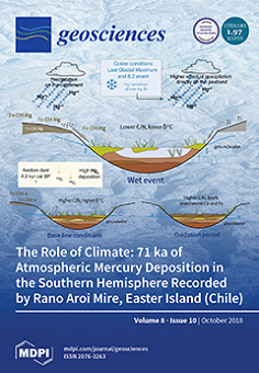
The reconstruction of 71 ka of atmospheric Hg deposition from a remote peatland in Easter Island showed the role of natural processes in local Hg accumulation. This paper is a good example of how climate (both precipitation and temperature) has controlled abrupt changes in Hg accumulation. Other processes, such as mire vegetation, peat decomposition, aeolian dust, oceanic evasion, and volcanic activity may have played a secondary role in Hg content. The combinations of all these processes caused a 28-fold range of variation in Hg concentrations in a remote and undisturbed area. Our maximum values are higher than those recorded in most peat records belonging to the Industrial Period, highlighting that natural factors played a significant role in local Hg accumulation—sometimes even more so than anthropogenic sources. View the paper here.
  • Issues are regarded as officially published after their release is announced to the table of contents alert mailing list.
  • You may sign up for e-mail alerts to receive table of contents of newly released issues.
  • PDF is the official format for papers published in both, html and pdf forms. To view the papers in pdf format, click on the "PDF Full-text" link, and use the free Adobe Reader to open them.
Order results
Result details
Section
Select all
Export citation of selected articles as:
18 pages, 2228 KiB  
Article
Analysis of Damage Caused by Hydrometeorological Disasters in Texas, 1960–2016
by Srikanto H. Paul and Hatim O. Sharif
Geosciences 2018, 8(10), 384; https://doi.org/10.3390/geosciences8100384 - 20 Oct 2018
Cited by 18 | Viewed by 4757
Abstract
Property damages caused by hydrometeorological disasters in Texas during the period 1960–2016 totaled $54.2 billion with hurricanes, tropical storms, and hail accounting for 56%, followed by flooding and severe thunderstorms responsible for 24% of the total damages. The current study provides normalized trends [...] Read more.
Property damages caused by hydrometeorological disasters in Texas during the period 1960–2016 totaled $54.2 billion with hurricanes, tropical storms, and hail accounting for 56%, followed by flooding and severe thunderstorms responsible for 24% of the total damages. The current study provides normalized trends to support the assertion that the increase in property damage is a combined contribution of stronger disasters as predicted by climate change models and increases in urban development in risk prone regions such as the Texas Gulf Coast. A comparison of the temporal distribution of damages normalized by population and GDP resulted in a less statistically significant increasing trend per capita. Seasonal distribution highlights spring as the costliest season (March, April and May) while the hurricane season (June through November) is well aligned with the months of highest property damage. Normalization of property damage by GDP during 2001–2016 showed Dallas as the only metropolitan statistical area (MSA) with a significant increasing trend of the 25 MSAs in Texas. Spatial analysis of property damage per capita highlighted the regions that are at greater risk during and after a major disaster given their limited economic resources compared to more urbanized regions. Variation in the causes of damage (wind or water) and types of damage that a “Hurricane” can produce was investigated using Hazus model simulation. A comparison of published damage estimates at time of occurrence with simulation outputs for Hurricanes Carla, 1961; Alicia, 1983; and Ike, 2008 based on 2010 building exposure highlighted the impact of economic growth, susceptibility of wood building types, and the predominant cause of damage. Carla and Ike simulation models captured less than 50% of their respective estimates reported by other sources suggesting a broad geographical zone of damage with flood damage making a significant contribution. Conversely, the model damage estimates for Alicia are 50% higher than total damage estimates that were reported at the time of occurrence suggesting a substantial increase in building exposure susceptible to wind damage in the modeled region from 1983 – 2010. Full article
(This article belongs to the Special Issue Hydrological Hazard: Analysis and Prevention)
Show Figures

Figure 1

17 pages, 5220 KiB  
Article
Efficiency of a Digital Particle Image Velocimetry (DPIV) Method for Monitoring the Surface Velocity of Hyper-Concentrated Flows
by Donatella Termini and Alice Di Leonardo
Geosciences 2018, 8(10), 383; https://doi.org/10.3390/geosciences8100383 - 19 Oct 2018
Cited by 6 | Viewed by 3202
Abstract
Digital particle image velocimetry records high resolution images and allows the identification of the position of points in different time instants. This paper explores the efficiency of the digital image-technique for remote monitoring of surface velocity and discharge measurement in hyper-concentrated flow by [...] Read more.
Digital particle image velocimetry records high resolution images and allows the identification of the position of points in different time instants. This paper explores the efficiency of the digital image-technique for remote monitoring of surface velocity and discharge measurement in hyper-concentrated flow by the way of laboratory experiment. One of the challenges in the application of the image-technique is the evaluation of the error in estimating surface velocity. The error quantification is complex because it depends on many factors characterizing either the experimental conditions or/and the processing algorithm. In the present work, attention is devoted to the estimation error due either to the acquisition time or to the size of the sub-images (interrogation areas) to be correlated. The analysis is conducted with the aid of data collected in a scale laboratory flume constructed at the Hydraulic laboratory of the Department of Civil, Environmental, Aerospace and of Materials Engineering (DICAM)—University of Palermo (Italy) and the image processing is carried out by the help of the PivLab algorithm in Matlab. The obtained results confirm that the number of frames used in processing procedure strongly affects the values of surface velocity; the estimation error decreases as the number of frames increases. The size of the interrogation area also exerts an important role in the flow velocity estimation. For the examined case, a reduction of the size of the interrogation area of one half compared to its original size has allowed us to obtain low values of the velocity estimation error. Results also demonstrate the ability of the digital image-technique to estimate the discharge at given cross-sections. The values of the discharge estimated by applying the digital image-technique downstream of the inflow sections by using the aforementioned size of the interrogation area compares well with those measured. Full article
(This article belongs to the Special Issue Laboratory Geosciences: Modelling Surface Processes)
Show Figures

Figure 1

16 pages, 8721 KiB  
Article
Geographies and Scientometrics of Research on Natural Hazards
by Adam Emmer
Geosciences 2018, 8(10), 382; https://doi.org/10.3390/geosciences8100382 - 18 Oct 2018
Cited by 31 | Viewed by 5684
Abstract
This contribution aims to reveal patterns of research on natural hazards worldwide, based on the analysis of the Clarivate Analytics Web of Science database. A set of 588,424 research items published between 1900 and 2017 is analyzed, covering different types of natural hazards. [...] Read more.
This contribution aims to reveal patterns of research on natural hazards worldwide, based on the analysis of the Clarivate Analytics Web of Science database. A set of 588,424 research items published between 1900 and 2017 is analyzed, covering different types of natural hazards. Two categories of natural hazards are distinguished in this study: (i) geological/geomorphic (earthquakes, slope movements, erosion, volcanic activity, and others); and (ii) climatic/hydro-meteorological (floods, storms, drought, hurricane, and others). General trends, the geographical focus, and the involvement and cooperation between individual countries are revealed, pointing out certain patterns (e.g., hotspots of research) and trends (e.g., changing publishing paradigm). Further, a global overview of research on natural hazards is confronted with disastrous events, fatalities, and losses of MunichRE and SwissRE global databases of natural disasters. Full article
Show Figures

Figure 1

14 pages, 11542 KiB  
Article
Residents’ Perception and Assessment of Geomorphosites of the Alvão—Chaves Region
by Bruno Martins and Andreia Pereira
Geosciences 2018, 8(10), 381; https://doi.org/10.3390/geosciences8100381 - 18 Oct 2018
Cited by 10 | Viewed by 3036
Abstract
This work focuses on the paradigms of a multidimensional and interdisciplinary evaluation of geomorphological heritage and its valorisation within a geosystemic reading of relations between a geomorphological and cultural landscape. This research aims to (i) select geomorphosites at different scales, which represent the [...] Read more.
This work focuses on the paradigms of a multidimensional and interdisciplinary evaluation of geomorphological heritage and its valorisation within a geosystemic reading of relations between a geomorphological and cultural landscape. This research aims to (i) select geomorphosites at different scales, which represent the regional geodiversity, according to an interdisciplinary approach; and (ii) better understand the perception of the local population concerning the different values of geomorphosites by applying a questionnaire that addresses the scientific, preservation, use, cultural, and educational dimensions. First, the authors selected the geomorphosites at a regional level by respecting the following criteria: (i) representativeness of the landform as a morphogenetic process; (ii) the witnessed periods of morpho-dynamics with potential to contribute to the reconstruction of paleoenvironmental conditions; (iii) the current morpho-dynamic nature; (iv) the importance to the shaping of the cultural landscape; and (v) the use value. Results showed that the major landforms are perceived as those with greater value by the local populations. Full article
(This article belongs to the Special Issue Geotourism)
Show Figures

Figure 1

25 pages, 4941 KiB  
Article
Acid Neutralization by Mining Waste Dissolution under Conditions Relevant for Agricultural Applications
by Reinier Van Noort, Pål Tore Mørkved and Siv Hjorth Dundas
Geosciences 2018, 8(10), 380; https://doi.org/10.3390/geosciences8100380 - 16 Oct 2018
Cited by 11 | Viewed by 3558
Abstract
The acidification of agricultural soils in high rainfall regions is usually countered by the application of finely ground calcite or dolomite. As this carbonate dissolves, soil pH is raised, but CO2 is released. Mining activities often produce large quantities of very fine [...] Read more.
The acidification of agricultural soils in high rainfall regions is usually countered by the application of finely ground calcite or dolomite. As this carbonate dissolves, soil pH is raised, but CO2 is released. Mining activities often produce large quantities of very fine silicate rock-derived powders that are commonly deposited in stockpiles. However, the dissolution of such powders can also result in an increase in pH, without any direct release of CO2. Of particular interest are those silicate powders that have a high reactivity and higher capacity for raising pH. In this contribution, we report experimental work addressing the dissolution of various silicate rock-derived powders that were produced during mining activities in Norway under conditions that were representative of weathering in agricultural soils. Three different powders—derived from Åheim dunite, Stjernøya nepheline syenite, or Tellnes ilmenite norite—were exposed to different acids at pH 4 in unstirred flow cells, and dissolution or leaching kinetics were determined from the changes in the fluid composition. Based on these kinetics, pH neutralization rates were determined for the individual powders and compared to expected values for carbonates. Based on this comparison, it is concluded that the application of silicate rock-derived powder dissolution to replace carbonate-based liming may not be feasible due to slower reaction rates, unless larger quantities of a finer particle size than normal are used. The application of larger volumes of slower-reacting silicates may have the additional benefit of reducing the required frequency of liming. Full article
(This article belongs to the Section Geochemistry)
Show Figures

Figure 1

16 pages, 4028 KiB  
Article
Where, What, When, and Why Is Bottom Mapping Needed? An On-Line Application to Set Priorities Using Expert Opinion
by Matthew S. Kendall, Ken Buja, Charles Menza and Tim Battista
Geosciences 2018, 8(10), 379; https://doi.org/10.3390/geosciences8100379 - 16 Oct 2018
Cited by 7 | Viewed by 3297
Abstract
Globally, there is a lack of resources to survey the vast seafloor areas in need of basic mapping data. Consequently, smaller areas must be prioritized to address the most urgent needs. We developed a systematic, quantitative approach and on-line application to gather mapping [...] Read more.
Globally, there is a lack of resources to survey the vast seafloor areas in need of basic mapping data. Consequently, smaller areas must be prioritized to address the most urgent needs. We developed a systematic, quantitative approach and on-line application to gather mapping suggestions from diverse stakeholders. Participants are each provided with 100 virtual coins to place throughout a region of interest to convey their mapping priorities. Inputs are standardized into a spatial framework using a grid and pull-down menus. These enabled participants to convey the types of mapping products that they need, the rationale used to justify their needs, and the locations that they prioritize for mapping. This system was implemented in a proposed National Marine Sanctuary encompassing 2784 km2 of Lake Michigan, Wisconsin. We demonstrate key analyses of the outputs, including coin counts, cell ranking, and multivariate cluster analysis for isolating high priority topics and locations. These techniques partition the priorities among the disciplines of the respondents, their selected justifications, and types of desired map products. The results enable respondents to identify potential collaborations to achieve common goals and more effectively invest limited mapping funds. The approach can be scaled to accommodate larger geographic areas and numbers of participants and is not limited to seafloor mapping. Full article
(This article belongs to the Special Issue Geological Seafloor Mapping)
Show Figures

Figure 1

14 pages, 2642 KiB  
Article
Simulations of Moisture Gradients in Wood Subjected to Changes in Relative Humidity and Temperature Due to Climate Change
by Charlotta Bylund Melin, Carl-Eric Hagentoft, Kristina Holl, Vahid M. Nik and Ralf Kilian
Geosciences 2018, 8(10), 378; https://doi.org/10.3390/geosciences8100378 - 15 Oct 2018
Cited by 27 | Viewed by 4813
Abstract
Climate change is a growing threat to cultural heritage buildings and objects. Objects housed in historic buildings are at risk because the indoor environments in these buildings are difficult to control and often influenced by the outdoor climate. Hygroscopic materials, such as wood, [...] Read more.
Climate change is a growing threat to cultural heritage buildings and objects. Objects housed in historic buildings are at risk because the indoor environments in these buildings are difficult to control and often influenced by the outdoor climate. Hygroscopic materials, such as wood, will gain and release moisture during changes in relative humidity and temperature. These changes cause swelling and shrinkage, which may result in permanent damage. To increase the knowledge of climate-induced damage to heritage objects, it is essential to monitor moisture transport in wood. Simulation models need to be developed and improved to predict the influence of climate change. In a previous work, relative humidity and temperature was monitored at different depths inside wooden samples subjected to fluctuating climate over time. In this article, two methods, the hygrothermal building simulation software WUFI® Pro and the Simplified model, were compared in relation to the measured data. The conclusion was that both methods can simulate moisture diffusion and transport in wooden object with a sufficient accuracy. Using the two methods for predicted climate change data show that the mean RH inside wood is rather constant, but the RH minimum and maximum vary with the predicted scenario and the type of building used for the simulation. Full article
Show Figures

Figure 1

17 pages, 7821 KiB  
Article
Landslide Disasters Triggered by Extreme Rainfall Events: The Case of Montescaglioso (Basilicata, Southern Italy)
by Maurizio Lazzari and Marco Piccarreta
Geosciences 2018, 8(10), 377; https://doi.org/10.3390/geosciences8100377 - 15 Oct 2018
Cited by 39 | Viewed by 4200
Abstract
We present the results of the study of a large and rapid landslide disaster event, which occurred in Montescaglioso, southern Italy, on 3 December 2013. The studied landslide developed following extreme rainfalls in a zone characterized by a stabilized paleo-landslide body and anthropized [...] Read more.
We present the results of the study of a large and rapid landslide disaster event, which occurred in Montescaglioso, southern Italy, on 3 December 2013. The studied landslide developed following extreme rainfalls in a zone characterized by a stabilized paleo-landslide body and anthropized in time, filling some streams of the original hydrographic network. The morpho-topographic setting characterizing the slope before the new landslide, has showed, in fact, a substantial stability confirmed also by the application of SINMAP (Stability Index MAPping) analysis. Nevertheless, heavy rains and floods caused a powerful and spectacular landslide event because of the anthropic removal of the old drainage network, which has caused the heaviness of the slope located upstream of the 20 collapsed buildings and along the ill-drained quick-road, built transversely to the slope. Full article
(This article belongs to the Special Issue Quantitative Geomorphology)
Show Figures

Figure 1

16 pages, 782 KiB  
Article
The Riding Trail as Geotourism Attraction: Evidence from Iceland
by Guðrún Helgadóttir and Ingibjörg Sigurðardóttir
Geosciences 2018, 8(10), 376; https://doi.org/10.3390/geosciences8100376 - 12 Oct 2018
Cited by 6 | Viewed by 4058
Abstract
The geological aspects of tourism are much more extensive than just places to be viewed and/or experienced. The terrain traveled is also a geological phenomenon and an attraction in itself. For a hiker or a rider the type of trail is important. Features [...] Read more.
The geological aspects of tourism are much more extensive than just places to be viewed and/or experienced. The terrain traveled is also a geological phenomenon and an attraction in itself. For a hiker or a rider the type of trail is important. Features of the trail such as the gradient, altitude, the soil qualities, the length and the vistas it affords are important geological considerations. The trail as an experienced geological attraction, or should we say, the foundation for horse based tourism, particularly long rides, is the topic of this paper. The research is based on different sources. Existing data from earlier research on the Icelandic horse industry and equestrian tourism are used, as well as eight interviews conducted for this study. Further, the authors use their personal experiences as riders and horse tourists to reflect on the topic. Findings indicate that the riding trail and its surroundings can be defined as geosites and equestrian tourists as casual geotourists. The trails as geosites have different values for its stakeholders. The trails seem to have values such as scientific/educational, cultural/heritage, scenic and touristic values, just as other geosites. Furthermore, we argue that riding trails do have an economic value, as well as an emotional/romantic value. Full article
(This article belongs to the Special Issue Geotourism)
Show Figures

Figure 1

14 pages, 3131 KiB  
Article
Paleoenvironment Variability during Termination I at the Reykjanes Ridge, North Atlantic
by Alexander Matul, Max S. Barash, Tatyana A. Khusid, Padmasini Behera and Manish Tiwari
Geosciences 2018, 8(10), 375; https://doi.org/10.3390/geosciences8100375 - 11 Oct 2018
Cited by 7 | Viewed by 2910
Abstract
The micropaleontological study (radiolarians and foraminifera) of the sediment core AMK-340, Reykjanes Ridge, North Atlantic, combined with the radiocarbon dating and oxygen and carbon isotopic record, provided data for the reconstruction of the summer paleotemperature across the upper 100 meters water depth range, [...] Read more.
The micropaleontological study (radiolarians and foraminifera) of the sediment core AMK-340, Reykjanes Ridge, North Atlantic, combined with the radiocarbon dating and oxygen and carbon isotopic record, provided data for the reconstruction of the summer paleotemperature across the upper 100 meters water depth range, and paleoenvironments during the Termination I in the age interval of 14.5–8 ka. The response of the main microfossil species to the paleoceanographic changes within the Bølling-Allerød (BA) warming, the Younger Dryas (YD) cold event and final transition to the warm Holocene, was different. The BA warming was well captured by the radiolarian and benthic foraminiferal records, but not the planktic one. The high abundances of the cold-water radiolarian species Amphimelissa setosa as a Greenland/Iceland Sea indicator marked a cooling at the end of the BA and at the start of the YD at 13.2–12.3 ka. The micropaleontological and isotopic data together with the paleotemperature estimates for the Reykjanes Ridge at 60°N document that, after the warm BA, the middle YD ca. 12.5–12.2 ka was the next significant step toward the Holocene warming. The start of the Holocene interglacial conditions was reflected in large representation of the microfossils being indicators of the open boreal North Atlantic environments indicating increasing warmth. Full article
(This article belongs to the Section Biogeosciences)
Show Figures

Figure 1

19 pages, 2551 KiB  
Article
The Role of Climate: 71 ka of Atmospheric Mercury Deposition in the Southern Hemisphere Recorded by Rano Aroi Mire, Easter Island (Chile)
by Marta Pérez-Rodríguez, Olga Margalef, Juan Pablo Corella, Alfonso Saiz-Lopez, Sergi Pla-Rabes, Santiago Giralt and Antonio Martínez Cortizas
Geosciences 2018, 8(10), 374; https://doi.org/10.3390/geosciences8100374 - 11 Oct 2018
Cited by 10 | Viewed by 4068
Abstract
The study of mercury accumulation in peat cores provides an excellent opportunity to improve the knowledge on mercury cycling and depositional processes at remote locations far from pollution sources. We analyzed mercury concentrations in 150 peat samples from two cores from Rano Aroi [...] Read more.
The study of mercury accumulation in peat cores provides an excellent opportunity to improve the knowledge on mercury cycling and depositional processes at remote locations far from pollution sources. We analyzed mercury concentrations in 150 peat samples from two cores from Rano Aroi (Easter Island, 27° S) and in selected vegetation samples of present-day flora of the island, in order to characterize the mercury cycling for the last ~71 ka BP. The mercury concentrations showed values ranging between 35 and 200 ng g−1, except for a large maxima (~1000 ng g−1) which occurred at the end of the Last Glacial Maximum (LGM, ~20 ka cal BP) in both peat cores. Low temperatures during the LGM would accelerate the atmospheric oxidation of Hg(0) to divalent mercury that, coupled with higher rainfall during this period, most likely resulted in a very efficient surface deposition of atmospheric mercury. Two exceptional short-lived Hg peaks occurred during the Holocene at 8.5 (350 ng g−1) and 4.7 (1000 ng g−1) ka cal BP. These values are higher than those recorded in most peat records belonging to the industrial period, highlighting that natural factors played a significant role in Hg accumulation—sometimes even more so than anthropogenic sources. Our results suggest that wet deposition, linked to atmospheric oxidation, was the main process controlling the short-lived Hg events, both in the mire and in the catchment soils. Full article
(This article belongs to the Special Issue Mercury Biogeochemical Cycle in A Changing World)
Show Figures

Graphical abstract

16 pages, 9719 KiB  
Article
Gravity Data Inversion with Method of Local Corrections for Finite Elements Models
by Petr S. Martyshko, Igor V. Ladovskii, Denis D. Byzov and Alexander G. Tsidaev
Geosciences 2018, 8(10), 373; https://doi.org/10.3390/geosciences8100373 - 10 Oct 2018
Cited by 15 | Viewed by 3848
Abstract
We present a new method for gravity data inversion for the linear problem (reconstruction of density distribution by given gravity field). This is an iteration algorithm based on the ideas of local minimization (also known as local corrections method). Unlike the gradient methods, [...] Read more.
We present a new method for gravity data inversion for the linear problem (reconstruction of density distribution by given gravity field). This is an iteration algorithm based on the ideas of local minimization (also known as local corrections method). Unlike the gradient methods, it does not require a nonlinear minimization, is easier to implement and has better stability. The algorithm is based on the finite element method. The finite element approach in our study means that the medium (part of a lithosphere) is represented as a set of equal rectangular prisms, each with constant density. We also suggest a time-efficient optimization, which speeds up the inversion process. This optimization is applied on the gravity field calculation stage, which is a part of every inversion iteration. Its idea is to replace multiple calculations of the gravity field for all finite elements in all observation points with a pre-calculated set of uniform fields for all distances between finite element and observation point, which is possible for the current data set. Method is demonstrated on synthetic data and real-world cases. The case study area is located on the Timan-Pechora plate. This region is one of the promising oil- and gas-producing areas in Russia. Note that in this case we create a 3D density model using joint interpretation of seismic and gravity data. Full article
(This article belongs to the Special Issue Numerical Methods of Geophysical Fields Inversion)
Show Figures

Figure 1

22 pages, 3041 KiB  
Article
Assessment of Leachate Production from a Municipal Solid-Waste Landfill through Water-Balance Modeling
by Steffen Beck-Broichsitter, Horst H. Gerke and Rainer Horn
Geosciences 2018, 8(10), 372; https://doi.org/10.3390/geosciences8100372 - 10 Oct 2018
Cited by 14 | Viewed by 4673
Abstract
Mineral temporary capping systems of landfills are required to accomplish the long-term coverage prerequisites or to use them as a basis layer prior to later permanent sealing. Such a capping system for a municipal waste landfill in Rastorf (Northern Germany) was developed and [...] Read more.
Mineral temporary capping systems of landfills are required to accomplish the long-term coverage prerequisites or to use them as a basis layer prior to later permanent sealing. Such a capping system for a municipal waste landfill in Rastorf (Northern Germany) was developed and tested for its sealing capability on the basis of observed and simulated water balance components for the period between 2008 and 2015, considering observed local weather data and complemented by the Hydraulic Evaluation of Landfill Performance (HELP 3.95 D) model. The modeling results of this case study could be improved by the correction of previously used global solar radiation data due to the consideration of exposure and inclination angle of landfill surface areas. The model could positively be validated by comparing observed and simulated outflow (surface runoff and lateral drainage) data with R2 values ranging between 0.95 and 0.99, as well as for the leachate rates with R2 values of 0.78–0.87. The statistical-empirical HELP model was found useful in predicting the leachate generation of a temporary landfill capping system for specific soil and site conditions, even if only a restricted set of observed data was available. Full article
Show Figures

Graphical abstract

16 pages, 4548 KiB  
Case Report
A Novel Method for Evaluation of Flood Risk Reduction Strategies: Explanation of ICPR FloRiAn GIS-Tool and Its First Application to the Rhine River Basin
by Adrian Schmid-Breton, Gesa Kutschera, Ton Botterhuis and The ICPR Expert Group ‘Flood Risk Analysis’ (EG HIRI)
Geosciences 2018, 8(10), 371; https://doi.org/10.3390/geosciences8100371 - 06 Oct 2018
Cited by 5 | Viewed by 4109
Abstract
To determine the effects of measures on flood risk, the International Commission for the Protection of the Rhine (ICPR), supported by the engineering consultant HKV has developed a method and a GIS-tool named “ICPR FloRiAn (Flood Risk Analysis)”, which enables the broad-scale assessment [...] Read more.
To determine the effects of measures on flood risk, the International Commission for the Protection of the Rhine (ICPR), supported by the engineering consultant HKV has developed a method and a GIS-tool named “ICPR FloRiAn (Flood Risk Analysis)”, which enables the broad-scale assessment of the effectiveness of flood risk management measures on the Rhine, but could be also applied to other rivers. The tool uses flood hazard maps and associated recurrence periods for an overall damage and risk assessment for four receptors: human health, environment, culture heritage, and economic activity. For each receptor, a method is designed to calculate the impact of flooding and the effect of measures. The tool consists of three interacting modules: damage assessment, risk assessment, and measures. Calculations using this tool show that the flood risk reduction target defined in the Action Plan on Floods of the ICPR in 1998 could be achieved with the measures already taken and those planned until 2030. Upon request, the ICPR will provide this tool and the method to other river basin organizations, national authorities, or scientific institutions. This article presents the method and GIS-tool developed by the ICPR as well as first calculation results. Full article
(This article belongs to the Special Issue Hydrological Hazard: Analysis and Prevention)
Show Figures

Figure 1

17 pages, 4314 KiB  
Article
A Methodology for Long-Term Monitoring of Climate Change Impacts on Historic Buildings
by Annika Haugen, Chiara Bertolin, Gustaf Leijonhufvud, Tone Olstad and Tor Broström
Geosciences 2018, 8(10), 370; https://doi.org/10.3390/geosciences8100370 - 04 Oct 2018
Cited by 28 | Viewed by 4798
Abstract
A new methodology for long-term monitoring of climate change impacts on historic buildings and interiors has been developed. This paper proposes a generic framework for how monitoring programs can be developed and describes the planning and arrangement of a Norwegian monitoring campaign. The [...] Read more.
A new methodology for long-term monitoring of climate change impacts on historic buildings and interiors has been developed. This paper proposes a generic framework for how monitoring programs can be developed and describes the planning and arrangement of a Norwegian monitoring campaign. The methodology aims to make it possible to establish a data-driven decision making process based on monitored decay related to climate change. This monitoring campaign includes 45 medieval buildings distributed over the entirety of Norway. Thirty-five of these buildings are dated to before 1537 and include wooden buildings as well as 10 medieval churches built in stone while the remaining 10 buildings are situated in the World Heritage sites of Bryggen, in Bergen on the west coast of Norway, and in Røros, which is a mining town in the inland of the country. The monitoring is planned to run for 30 to 50 years. It includes a zero-level registration and an interval-based registration system focused on relevant indicators, which will make it possible to register climate change-induced decay at an early stage. Full article
Show Figures

Figure 1

13 pages, 4262 KiB  
Article
Application of Radial Basis Functions for Height Datum Unification
by Ismael Foroughi, Abdolreza Safari, Pavel Novák and Marcelo C. Santos
Geosciences 2018, 8(10), 369; https://doi.org/10.3390/geosciences8100369 - 02 Oct 2018
Cited by 8 | Viewed by 3346
Abstract
Local gravity field modelling demands high-quality gravity data as well as an appropriate mathematical model. Particularly in coastal areas, there may be different types of gravity observations available, for instance, terrestrial, aerial, marine gravity, and satellite altimetry data. Thus, it is important to [...] Read more.
Local gravity field modelling demands high-quality gravity data as well as an appropriate mathematical model. Particularly in coastal areas, there may be different types of gravity observations available, for instance, terrestrial, aerial, marine gravity, and satellite altimetry data. Thus, it is important to develop a proper tool to merge the different data types for local gravity field modelling and determination of the geoid. In this study, radial basis functions, as a commonly useful tool for gravity data integration, are employed to model the gravity potential field of the southern part of Iran using terrestrial gravity anomalies, gravity anomalies derived from re-tracked satellite altimetry, marine gravity anomalies, and gravity anomalies synthesized from an Earth gravity model. Reference GNSS/levelling (geometric) geoidal heights are used to evaluate the accuracy of the estimated local gravity field model. The gravimetric geoidal heights are in acceptable agreement with the geometric ones in terms of the standard deviation and the mean value which are 4.1 and 12 cm, respectively. Besides, the reference benchmark of the national first-order levelling network of Iran is located in the study area. The derived gravity model was used to compute the gravity potential difference at this point and then transformed into a height difference which results in the value of the shift of this benchmark with respect to the geoid. The estimated shift shows a good agreement with previously published studies. Full article
(This article belongs to the Special Issue Gravity Field Determination and Its Temporal Variation)
Show Figures

Figure 1

32 pages, 4785 KiB  
Article
Geotourism Perspectives for Transhumance Routes. Analysis, Requalification and Virtual Tools for the Geoconservation Management of the Drove Roads in Southern Italy
by Monica Meini, Giuseppe Di Felice and Marco Petrella
Geosciences 2018, 8(10), 368; https://doi.org/10.3390/geosciences8100368 - 01 Oct 2018
Cited by 21 | Viewed by 5394
Abstract
The article illustrates the interest in transhumance routes, the ancient paths connecting high and lowland pastures in Southern Italy and other Mediterranean regions, as elements of particular importance for sustainable geotourism management. As a contribution to the needs of requalification of the drove [...] Read more.
The article illustrates the interest in transhumance routes, the ancient paths connecting high and lowland pastures in Southern Italy and other Mediterranean regions, as elements of particular importance for sustainable geotourism management. As a contribution to the needs of requalification of the drove roads, we propose a method of analysis for their preservation and their reuse for geotourism purposes, showing the steps and instruments necessary to organize, enhance and communicate transhumance routes as integrated cultural landscapes. Results are presented as applied to a specific case study (Molise, IT) of a geoconservation management proposal for the assessment of the state of conservation of the drove roads, of their cultural heritage and of their potential reuse for geotourism. This methodological proposal uses geographical information systems, historical sources, cartography and remote sensing techniques and includes 3D virtual reconstructions of the transhumance landscape. The article is meant to contribute to a non-stereotyped image of transhumance geoheritage, reflecting on communication and learning strategies supported by geo-historical analyses, in order to promote a greater awareness of landscapes genesis and evolution for visitors and local communities. It is argued that future challenges of geotourism relate to the ability to recompose nature and culture to an interpretive unity, both from a theoretical and operative point of view, and that the goal is to reach an integrated tourist offer focused on the relationship between man and environment with the signs of territorialisation processes expressed through economic vocations, traditional production chains, cultural values and territorial identity. To this purpose, the valorisation of the transhumance routes—for their historical-economic, ecological, landscape, patrimonial and identity meanings—seems to respond perfectly. Full article
(This article belongs to the Special Issue Geotourism)
Show Figures

Figure 1

21 pages, 11434 KiB  
Article
Pressure–Temperature History of the >3 Ga Tartoq Greenstone Belt in Southwest Greenland and Its Implications for Archaean Tectonics
by Vincent Van Hinsberg, Catherine Crotty, Stan Roozen, Kristoffer Szilas and Alexander Kisters
Geosciences 2018, 8(10), 367; https://doi.org/10.3390/geosciences8100367 - 30 Sep 2018
Cited by 8 | Viewed by 4332
Abstract
The Tartoq greenstone belt of southwest Greenland represents a well-preserved section through >3 Ga old oceanic crust and has the potential to provide important constraints on the composition and geodynamics of the Archaean crust. Based on a detailed structural examination, it has been [...] Read more.
The Tartoq greenstone belt of southwest Greenland represents a well-preserved section through >3 Ga old oceanic crust and has the potential to provide important constraints on the composition and geodynamics of the Archaean crust. Based on a detailed structural examination, it has been proposed that the belt records an early style of horizontal convergent plate tectonics where elevated temperatures, compared to the modern-day, led to repeated aborted subduction and tonalite–trondhjemite–granodiorite (TTG) type melt formation. This interpretation hinges on pressure–temperature (P–T) constraints for the belt, for which only preliminary estimates are currently available. Here, we present a detailed study of the pressure–temperature conditions and metamorphic histories for rocks from all fragments of the Tartoq belt using pseudosection modelling and geothermobarometry. We show that peak conditions are predominantly amphibolite facies, but range from 450 to 800 °C at up to 7.5 kbar; reaching anatexis with formation of TTG-type partial melts in the Bikuben segment. Emplacement of the Tartoq segments into the host TTG gneisses took place at approximately 3 Ga at 450–500 °C and 4 kbar as constrained from actinolite–chlorite–epidote–titanite–quartz parageneses, and was followed by extensive hydrothermal retrogression related to formation of shear zone-hosted gold mineralisation. Tourmaline thermometry and retrograde assemblages in mafic and ultramafic lithologies constrain this event to 380 ± 50 °C at a pressure below 1 kbar. Our results show that the convergent tectonics recorded by the Tartoq belt took place at a P–T gradient markedly shallower than that of modern-day subduction, resulting in a hot, weak and buoyant slab unable to generate and transfer ‘slab pull’, nor sustain a single continuous downgoing slab. The Tartoq belt suggests that convergence was instead accomplished by under-stacking of slabs from repeated aborted subduction. The shallow P–T path combined with thermal relaxation following subduction stalling subsequently resulted in partial melting and formation of TTG melts. Full article
(This article belongs to the Special Issue Geology of the Early Earth – Geodynamic Constraints from Cratons)
Show Figures

Figure 1

19 pages, 4941 KiB  
Article
The Use of High-Resolution Historical Images to Analyse the Leopard Pattern in the Arid Area of La Alta Guajira, Colombia
by José Fuentes, Diego Varga and Josep Pintó
Geosciences 2018, 8(10), 366; https://doi.org/10.3390/geosciences8100366 - 29 Sep 2018
Cited by 5 | Viewed by 3379
Abstract
A recent review of global arid areas supports the idea that there are two patterns to vegetation in arid lands. Patches of thick vegetation alternate with those with much less vegetation or none at all. There is a specific size, shape and spatial [...] Read more.
A recent review of global arid areas supports the idea that there are two patterns to vegetation in arid lands. Patches of thick vegetation alternate with those with much less vegetation or none at all. There is a specific size, shape and spatial distribution that characterizes vegetation patterns in arid land ecosystems. In some places, the patches have irregular shapes; these are called spots or Leopard bush. This research project is based on a biophysical approach that integrates information collected in the field, high resolution historical satellite images and Geographical Information System technology. The results revealed that there were certain places in the landscape that facilitate the singular development of the vegetation. The Leopard pattern results from the interaction of various factors (fertility island, fragmentation of vegetation, anthropic influence, herbivorism). Specific characteristics that limit plant life forms are found in the area; since only certain resistant species develop, these form associations and in turn generate strategies to optimize resources. Eventually, this equilibrium is disturbed by human activities in the shape of ungulate livestock breeding and anthropogenic activities, resulting in a heterogeneity of soils and vegetation whose interaction generates the pattern. Full article
(This article belongs to the Section Biogeosciences)
Show Figures

Figure 1

34 pages, 1293 KiB  
Review
Microlensing Searches for Exoplanets
by Yiannis Tsapras
Geosciences 2018, 8(10), 365; https://doi.org/10.3390/geosciences8100365 - 29 Sep 2018
Cited by 33 | Viewed by 7467
Abstract
Gravitational microlensing finds planets through their gravitational influence on the light coming from a more distant background star. The presence of the planet is then inferred from the tell-tale brightness variations of the background star during the lensing event, even if no light [...] Read more.
Gravitational microlensing finds planets through their gravitational influence on the light coming from a more distant background star. The presence of the planet is then inferred from the tell-tale brightness variations of the background star during the lensing event, even if no light is detectable from the planet or the host foreground star. This review covers fundamental theoretical concepts in microlensing, addresses how observations are performed in practice, the challenges of obtaining accurate measurements, and explains how planets reveal themselves in the data. It concludes with a presentation of the most important findings to-date, a description of the method’s strengths and weaknesses, and a discussion of the future prospects of microlensing. Full article
(This article belongs to the Special Issue Detection and Characterization of Extrasolar Planets)
Show Figures

Figure 1

25 pages, 7420 KiB  
Article
Development of a Distributed Hydrologic Model for a Region with Fragipan Soils to Study Impacts of Climate on Soil Moisture: A Case Study on the Obion River Watershed in West Tennessee
by Seyed Ghaneeizad, Athanasios (Thanos) Papanicolaou, Benjamin Abban, Christopher Wilson, Christos Giannopoulos, Dayton Lambert, Forbes Walker and Shawn Hawkins
Geosciences 2018, 8(10), 364; https://doi.org/10.3390/geosciences8100364 - 29 Sep 2018
Cited by 3 | Viewed by 3347
Abstract
Previous land surface modeling efforts to predict and understand water budgets in the U.S. Southeast for soil water management have struggled to characterize parts of the region due to an extensive presence of fragipan soils for which current calibration approaches are not adept [...] Read more.
Previous land surface modeling efforts to predict and understand water budgets in the U.S. Southeast for soil water management have struggled to characterize parts of the region due to an extensive presence of fragipan soils for which current calibration approaches are not adept at handling. This study presents a physically based approach for calibrating fragipan-dominated regions based on the “effective” soil moisture capacity concept, which accounts for the dynamic perched saturation zone effects created by the low hydraulic capacities of the fragipan layers. The approach is applied to the Variable Infiltration Capacity model to develop a hydrologic model of the Obion River Watershed (ORW), TN, which has extensive fragipan coverage. Model calibration was performed using observed streamflow data, as well as evapotranspiration and soil moisture data, to ensure correct partitioning of surface and subsurface fluxes. Estimated Nash-Sutcliffe coefficients for the various sub-drainage areas within ORW were all greater than 0.65, indicating good model performance. The model results suggest that ORW has a high responsivity and high resilience. Despite forecasted temperature increases, the simulation results suggest that water budget trends in the ORW are unlikely to change significantly in the near future up to 2050 due to sufficient precipitation amounts. Full article
(This article belongs to the Special Issue Mechanics of Erosion: Process Response to Change)
Show Figures

Figure 1

11 pages, 4502 KiB  
Article
Topographic Anaglyphs from Detailed Digital Elevation Models Covering Inland and Seafloor for the Tectonic Geomorphology Studies in and around Yoron Island, Ryukyu Arc, Japan
by Hideaki Goto, Kohsaku Arai and Taichi Sato
Geosciences 2018, 8(10), 363; https://doi.org/10.3390/geosciences8100363 - 29 Sep 2018
Cited by 6 | Viewed by 4185
Abstract
Anaglyphs produced using a digital elevation model (DEM) are effective to identify the characteristic tectono–geomorphic features. The objective of this study is to reinvestigate the tectonic geomorphology and to present novel tectonic maps of the late Quaternary in and around the Yoron island [...] Read more.
Anaglyphs produced using a digital elevation model (DEM) are effective to identify the characteristic tectono–geomorphic features. The objective of this study is to reinvestigate the tectonic geomorphology and to present novel tectonic maps of the late Quaternary in and around the Yoron island based on the interpretation of extensive topographical anaglyphs along the map areas that cover the inland and seafloor. Vintage aerial photographs are used to produce the 3-m mesh inland digital surface model (DSM); further, the 0.6-s to 2-s-mesh seafloor DEM is processed using the cloud point data generated through previous surveys. Thus, we identify anticlinal deformation on both the Pleistocene marine terrace and the seafloor to the north of the island. The deformation axis extends in a line and is parallel to the general trend of the island shelf. The Tsujimiya fault cuts the marine terraces, which extend to the Yoron basin’s seafloor. If we assume that the horizontal compressive stress axis is perpendicular to the island shelf, these properties can easily explain the distribution and style of the active faults and deformation. This study presents an effective methodology to understand the island arc tectonics, especially in case of small isolated islands. Full article
(This article belongs to the Special Issue Glacial and Geomorphological Cartography)
Show Figures

Graphical abstract

36 pages, 5102 KiB  
Review
A Review on Substellar Objects below the Deuterium Burning Mass Limit: Planets, Brown Dwarfs or What?
by José A. Caballero
Geosciences 2018, 8(10), 362; https://doi.org/10.3390/geosciences8100362 - 28 Sep 2018
Cited by 23 | Viewed by 6274
Abstract
“Free-floating, non-deuterium-burning, substellar objects” are isolated bodies of a few Jupiter masses found in very young open clusters and associations, nearby young moving groups, and in the immediate vicinity of the Sun. They are neither brown dwarfs nor planets. In this paper, their [...] Read more.
“Free-floating, non-deuterium-burning, substellar objects” are isolated bodies of a few Jupiter masses found in very young open clusters and associations, nearby young moving groups, and in the immediate vicinity of the Sun. They are neither brown dwarfs nor planets. In this paper, their nomenclature, history of discovery, sites of detection, formation mechanisms, and future directions of research are reviewed. Most free-floating, non-deuterium-burning, substellar objects share the same formation mechanism as low-mass stars and brown dwarfs, but there are still a few caveats, such as the value of the opacity mass limit, the minimum mass at which an isolated body can form via turbulent fragmentation from a cloud. The least massive free-floating substellar objects found to date have masses of about 0.004 Msol, but current and future surveys should aim at breaking this record. For that, we may need LSST, Euclid and WFIRST. Full article
(This article belongs to the Special Issue Detection and Characterization of Extrasolar Planets)
Show Figures

Figure 1

16 pages, 5094 KiB  
Article
Geomorphic Evolution of the Lilas River Fan Delta (Central Evia Island, Greece)
by Efthimios Karymbalis, Kanella Valkanou, Ioannis Tsodoulos, George Iliopoulos, Konstantinos Tsanakas, Vasilis Batzakis, Giorgos Tsironis, Christina Gallousi, Konstantinos Stamoulis and Konstantinos Ioannides
Geosciences 2018, 8(10), 361; https://doi.org/10.3390/geosciences8100361 - 26 Sep 2018
Cited by 12 | Viewed by 4780
Abstract
This paper presents the results of geomorphological investigations carried out on the Lilas River fan delta in central Evia Isl., Greece. A geomorphological map has been prepared using Digital Elevation Model analysis, aerial photos and Google Earth image interpretation, a reliable map of [...] Read more.
This paper presents the results of geomorphological investigations carried out on the Lilas River fan delta in central Evia Isl., Greece. A geomorphological map has been prepared using Digital Elevation Model analysis, aerial photos and Google Earth image interpretation, a reliable map of 1846, and extensive fieldwork. The Holocene sequence stratigraphy of the fan delta has been studied based on profiles of seven deep cores drilled by the municipal authorities. Two additional shallow boreholes were drilled with a portable drilling set and collected samples were analyzed using micropaleontological and grain size analysis methods while four sediment samples were dated using optically stimulated luminescence (OSL) techniques. During the early Holocene, most of the fan delta plain was a shallow marine environment. Between 4530 ± 220 and 3600 ± 240 years BP the depositional environment at the area of Nea Lampsakos changed from shallow marine to a lower energy lagoonal one. The main distributary changed its course several times leading to the building and subsequent abandonment of five fan delta lobes, through which the fan delta advanced during the late Holocene. The eastern part of the Kampos abandoned lobe is retreating with a maximum mean rate of −0.94 m/year for the period 1945–2009, whereas the presently active mouth of the river and its immediate surrounds are prograding with a mean rate of about +3.2 m/year. Full article
Show Figures

Figure 1

14 pages, 7622 KiB  
Article
Synchrotron-Based Micro-CT Investigation of Oxic Corrosion of Copper-Coated Carbon Steel for Potential Use in a Deep Geological Repository for Used Nuclear Fuel
by Thalia E. Standish, Dmitrij Zagidulin, Sridhar Ramamurthy, Peter G. Keech, David W. Shoesmith and James J. Noël
Geosciences 2018, 8(10), 360; https://doi.org/10.3390/geosciences8100360 - 26 Sep 2018
Cited by 7 | Viewed by 3634
Abstract
Within the multi-barrier system proposed for the permanent disposal of used nuclear fuel, the primary engineered barrier is the sealed metallic container. The present Canadian container design utilizes a carbon steel vessel coated with Cu for corrosion protection. In the event of a [...] Read more.
Within the multi-barrier system proposed for the permanent disposal of used nuclear fuel, the primary engineered barrier is the sealed metallic container. The present Canadian container design utilizes a carbon steel vessel coated with Cu for corrosion protection. In the event of a defect in the Cu coating that exposes the steel substrate, galvanically accelerated corrosion of steel is, in principle, possible. In this work, the progression of corrosion at a simulated through-coating defect in 3.0 mol/L NaCl solution containing dissolved O2 was monitored using electrochemical measurements and imaged non-destructively using synchrotron X-ray micro computed tomography (micro-CT). The damage volume at the base of the simulated defect was measured from the 3D micro-CT data and used to calculate the amount of O2 used to drive steel corrosion. The results demonstrate that the availability of O2 determines the rate and overall extent of corrosion, while the coatings produced using different deposition and treatment methods (cold spray deposition, heat-treated cold spray deposition, electrodeposition) lead to different corrosion propagation geometries, with the distribution of damage depending on the quality of the Cu/steel interface. Full article
Show Figures

Figure 1

18 pages, 4689 KiB  
Article
Coupled Model of Bank Erosion and Meander Evolution for Cohesive Riverbanks
by Kattia Rubi Arnez Ferrel, Supapap Patsinghasanee, Ichiro Kimura and Yasuyuki Shimizu
Geosciences 2018, 8(10), 359; https://doi.org/10.3390/geosciences8100359 - 22 Sep 2018
Cited by 8 | Viewed by 4340
Abstract
In this paper, a physics-based model that couples a bank erosion model with a meander evolution model is developed and evaluated. The physics-based bank erosion model considers the cantilever failure mechanism with slump blocks and decomposition effects. Moreover, bank accretion was considered using [...] Read more.
In this paper, a physics-based model that couples a bank erosion model with a meander evolution model is developed and evaluated. The physics-based bank erosion model considers the cantilever failure mechanism with slump blocks and decomposition effects. Moreover, bank accretion was considered using critical values of time required for landing, shear stresses and water depths. Two cases were tested. The first case consists of a hypothetical small-scale channel with cohesive riverbanks. Cross sections in the straight and curved part of the channel were compared to evaluate the curvature effect. Furthermore, the effect of the bank strength in the plan shape of the channel was tested in this case. The results show that the curvature increases the erosion rate in the outer bank and changes the cross-sectional profile by narrowing and widening the channel width. The plan shape of the channel changed as the bank strength was increased. In the second case, the model is compared with the River meander migration software (RVR meander) and the advantages and limitations of the model are discussed in terms of meander migration plan form and bank erosion processes. The results showed that the presented model is capable of simulating asymmetric bends. Full article
(This article belongs to the Special Issue Mechanics of Erosion: Process Response to Change)
Show Figures

Graphical abstract

21 pages, 2644 KiB  
Article
Prediction of Holocene Mercury Accumulation Trends by Combining Palynological and Geochemical Records of Lake Sediments (Black Forest, Germany)
by Martin Schütze, Gegeensuvd Tserendorj, Marta Pérez-Rodríguez, Manfred Rösch and Harald Biester
Geosciences 2018, 8(10), 358; https://doi.org/10.3390/geosciences8100358 - 21 Sep 2018
Cited by 10 | Viewed by 5587
Abstract
Forest vegetation plays a key role in the cycling of mercury (Hg) and organic matter (OM) in terrestrial ecosystems. Litterfall has been indicated as the major transport vector of atmospheric Hg to forest soils, which is eventually transported and stored in the sediments [...] Read more.
Forest vegetation plays a key role in the cycling of mercury (Hg) and organic matter (OM) in terrestrial ecosystems. Litterfall has been indicated as the major transport vector of atmospheric Hg to forest soils, which is eventually transported and stored in the sediments of forest lakes. Hence, it is important to understand how changes in forest vegetation affect Hg in soil and its biogeochemical cycling in lake systems. We investigated the pollen records and the geochemical compositions of sediments from two lakes (Schurmsee and Glaswaldsee) in the Black Forest (Germany) to evaluate whether long-term shifts in forest vegetation induced by climate or land use influenced Hg accumulation in the lakes. We were particularly interested to determine whether coniferous forests were associated with a larger export of Hg to aquatic systems than deciduous forests. Principal components analysis followed by principal component regression enabled us to describe the evolution of the weight of the latent processes determining the accumulation of Hg over time. Our results emphasize that the in-lake uptake of Hg during warm climate periods, soil erosion after deforestation and emissions from mining and other human activities triggered changes in Hg accumulation during the Holocene stronger than the changes caused by forest vegetation alone. Full article
(This article belongs to the Special Issue Mercury Biogeochemical Cycle in A Changing World)
Show Figures

Graphical abstract

17 pages, 6757 KiB  
Article
Using a Multi-Proxy Approach to Detect and Date a Buried part of the Hellenistic City Wall of Ainos (NW Turkey)
by Martin Seeliger, Anna Pint, Peter Frenzel, Paula K. Weisenseel, Ercan Erkul, Dennis Wilken, Tina Wunderlich, Sait Başaran, Heike Bücherl, Marina Herbrecht, Wolfgang Rabbel, Thomas Schmidts, Nina Szemkus and Helmut Brückner
Geosciences 2018, 8(10), 357; https://doi.org/10.3390/geosciences8100357 - 20 Sep 2018
Cited by 9 | Viewed by 5305
Abstract
Throughout mankind’s history, the need to secure and protect the home settlement was an essential one. This holds especially true for the city of Ainos (modern Enez) in Turkish Thrace. Due to its continuous settlement history since the 7th/6th century BC, several different [...] Read more.
Throughout mankind’s history, the need to secure and protect the home settlement was an essential one. This holds especially true for the city of Ainos (modern Enez) in Turkish Thrace. Due to its continuous settlement history since the 7th/6th century BC, several different types of city walls were built—sometimes even on top of each other—several of which have been preserved over time. To decipher the construction style, the course and the age of a buried city wall segment in the southern part of the former city, a geoscientific multi-proxy approach including magnetic gradiometer (MG) and electrical resistivity tomography (ERT) measurements in combination with granulometrical, sedimentological and microfaunistical investigations on sediment cores was applied. We were able to (1) present reasonable arguments for its Hellenistic age; (2) reveal the course of this wall segment and extrapolate it further north into a less studied area; and (3) demonstrate that in this near-coastal area, the former swampy terrain had been consolidated for constructing the wall. Our multi-proxy approach serves as a valuable example for investigating buried structures in archaeological contexts, avoiding a less-economical, time-consuming, or even forbidden excavation. Full article
Show Figures

Figure 1

15 pages, 2175 KiB  
Article
Suitability of Boulder Marl and Marsh Clay as Sealing Substrates for Landfill Capping Systems—A Practical Comparison
by Steffen Beck-Broichsitter, Horst H. Gerke and Rainer Horn
Geosciences 2018, 8(10), 356; https://doi.org/10.3390/geosciences8100356 - 20 Sep 2018
Cited by 4 | Viewed by 3648
Abstract
The effects of compaction on soil shrinkage behavior need to be considered for engineering long-term durable mineral liners of landfill capping systems. For this purpose, a new three-dimensional laser scanning device was coupled with a mathematical-empirical model to simultaneously determine the shrinkage behavior [...] Read more.
The effects of compaction on soil shrinkage behavior need to be considered for engineering long-term durable mineral liners of landfill capping systems. For this purpose, a new three-dimensional laser scanning device was coupled with a mathematical-empirical model to simultaneously determine the shrinkage behavior of a boulder marl (bm) and a marsh clay (mc). Therefore, both materials were precompacted in 200 soil cores (100 cm3) on the basis of the Proctor test results with five different degrees of compaction (bm1-bm5; mc1-mc5). Thus, the shrinkage behavior, intensity, and tendency were determined during a standardized drying experiment. The volume shrinkage index was used to describe the pore size dependent shrinkage tendency and was classified as high to very high (11.3–17.7%) for the marsh clay and medium (5.3–9.2%) for the boulder marl. Additionally, only the boulder marl (bm2), compacted up to 88% of Proctor density, could be installed as landfill bottom liner in drier locations if the local matric potentials did not exceed the previously highest observed drying range (i.e. values below −300 hPa), to avoid crack formation and generation. Full article
Show Figures

Graphical abstract

18 pages, 9313 KiB  
Article
Recession and Ice Surface Elevation Changes of Baranowski Glacier and Its Impact on Proglacial Relief (King George Island, West Antarctica)
by Joanna Sziło and Robert Józef Bialik
Geosciences 2018, 8(10), 355; https://doi.org/10.3390/geosciences8100355 - 20 Sep 2018
Cited by 19 | Viewed by 4040
Abstract
Glacial forefields areas are dynamic landscapes, and due to the glacier frontal position changes, they are sensitive to climatic fluctuations. The results of the analysis of aerial photos, satellite imagery, archival maps, and terrestrial laser scanning surveys are presented. These investigations reveal that [...] Read more.
Glacial forefields areas are dynamic landscapes, and due to the glacier frontal position changes, they are sensitive to climatic fluctuations. The results of the analysis of aerial photos, satellite imagery, archival maps, and terrestrial laser scanning surveys are presented. These investigations reveal that the ice surface decreased during the period 1989–2001, when almost the entire current forefield was already uncovered. Moreover, it is shown that, since 1969, there has been a relationship between the changes in air temperature and the changes of the annual front position rate of Baranowski Glacier. Specifically, the results demonstrate that during the cooling observed for the Antarctic Peninsula Regions since 2000, there is a deceleration of the recession rate and ice surface elevation changes of Baranowski Glacier. It is also shown that the fluctuation of the areal extent of the glacier as well as ice surface elevation changes are closely associated with proglacial relief. Moreover, it is shown that the difference in the retreat of the northern and southern tongue of the glacier can be explained by the presence of relatively warm water in the shallow bay, which can enhance the melting process of the northern part. In addition, existence of long flutes and crevasse fill ridges on the analyzed forefield of Baranowski Glacier suggest that the former episodes of its surge, which could happen at least in the northern part of the forefield and middle part of the southern forefield of the glacier. Full article
(This article belongs to the Special Issue Global Climate Change and Geological Processes)
Show Figures

Figure 1

Previous Issue
Next Issue
Back to TopTop