sustainability-logo

Journal Browser

Journal Browser

Sustainable and Smart Traffic Variation, Development and Analysis toward Multi-model and Multi-source Data

A topical collection in Sustainability (ISSN 2071-1050). This collection belongs to the section "Sustainable Transportation".

Viewed by 72013

Editors


E-Mail Website
Collection Editor
School of Traffic and Transportation Engineering, Central South University, Changsha, China
Interests: traffic safety; traffic flow analysis; transportation big-data processing

E-Mail Website
Collection Editor
Institute of Logistics Science and Engineering, Shanghai Maritime University, Shanghai, China
Interests: unmanned port; logistics operation and optimization; intelligent transportation systems; internet-of-port

E-Mail Website
Collection Editor
School of Traffic and Transportation, Northeast Forestry University, Harbin, China
Interests: traffic safety; intelligent transportation systems; traffic flow; green transportation

Topical Collection Information

Dear Colleagues,

Transportation systems play a significant role in our daily lives, including transferring goods among different countries, commuting, etc. The use of widely deployed traffic sensors helps us to collect large-scale traffic data. Many attempts have been made to exploit traffic variation and development trends by determining traffic data patterns, identifying transportation knowledge, etc. For instance, the efficiency of traffic management and control can be enhanced by accurately determining macroscopic and microscopic traffic patterns at the roadway/network level. Delivery efficiency can be also improved by enhancing intermodal transportation efficiency (maritime traffic, railway, etc.). In that way, we need to address many bottlenecks to clearly recognize traffic variation and development towards a future smart transportation era. Thus, the traffic community calls for novel frameworks and data sources for addressing these issues. Potential studies can be carried out to address the following: origination destination distribution prediction, fuel consumption, traffic volume analysis, missing data imputation, trajectory map matching, traffic safety analysis, etc.

This Topical Collection aims to invite studies which analyze and predict sustainable traffic variation, development, and analyses in the context of highway, maritime, and aviation traffic planning and management. The Topical Collection focuses on novel methodologies and approaches with various relevant traffic data sources. We invite submissions of full papers that fit the general theme of sustainable traffic variation, development and analysis with cutting-edge artificial techniques (AI) and large-scale data. Moreover, we encourage submissions from a broad range of research fields related to traffic data mining issues. Exemplary topics of interest include, but are not limited to:

  • Traffic flow distribution estimation, modeling and prediction;
  • Traffic data quality analysis and control, dealing with uncertainty and bias/error;
  • Traffic spatiotemporal feature exploitation and prediction from large-scale traffic data;
  • Computer vision technique-supported traffic demand analysis and prediction;
  • Traffic accident variation tendency identification and exploitation;
  • Routing choice behavior analysis and prediction regarding traffic patterns;
  • Sustainable traffic development measurements;
  • Intermodal traffic (maritime, roadway, rail, etc.) efficiency enhancement with AI technology.

Dr. Xinqiang Chen
Prof. Dr. Jinjun Tang
Prof. Dr. Yongsheng Yang
Prof. Dr. Wenhui Zhang
Collection Editors

Manuscript Submission Information

Manuscripts should be submitted online at www.mdpi.com by registering and logging in to this website. Once you are registered, click here to go to the submission form. Manuscripts can be submitted until the deadline. All submissions that pass pre-check are peer-reviewed. Accepted papers will be published continuously in the journal (as soon as accepted) and will be listed together on the collection website. Research articles, review articles as well as short communications are invited. For planned papers, a title and short abstract (about 100 words) can be sent to the Editorial Office for announcement on this website.

Submitted manuscripts should not have been published previously, nor be under consideration for publication elsewhere (except conference proceedings papers). All manuscripts are thoroughly refereed through a single-blind peer-review process. A guide for authors and other relevant information for submission of manuscripts is available on the Instructions for Authors page. Sustainability is an international peer-reviewed open access semimonthly journal published by MDPI.

Please visit the Instructions for Authors page before submitting a manuscript. The Article Processing Charge (APC) for publication in this open access journal is 2400 CHF (Swiss Francs). Submitted papers should be well formatted and use good English. Authors may use MDPI's English editing service prior to publication or during author revisions.

Keywords

  • traffic flow
  • data processing
  • computer vision
  • smart port
  • traffic safety
  • sustainable transportation
  • trajectory exploration
Published Papers (22 papers)

2024

Jump to: 2023, 2022, 2021, 2020

18 pages, 5105 KiB  
Article
Study on the Deviation Characteristics of Driving Trajectories for Autonomous Vehicles and the Design of Dedicated Lane Widths
by Yuansheng Cao, Yonggang Liao, Jiancong Lai, Tianjie Shen and Xiaofei Wang
Sustainability 2024, 16(21), 9155; https://doi.org/10.3390/su16219155 - 22 Oct 2024
Viewed by 856
Abstract
The vehicular trajectory offset represents a critical controlling element in the design of lane width. In light of the paucity of extant research on the lane widths for dedicated autonomous vehicle lanes, this study deployed the PreScan-Simulink co-simulation platform. Based on the established [...] Read more.
The vehicular trajectory offset represents a critical controlling element in the design of lane width. In light of the paucity of extant research on the lane widths for dedicated autonomous vehicle lanes, this study deployed the PreScan-Simulink co-simulation platform. Based on the established typical lateral and longitudinal control methods for autonomous vehicles, we initially identified the primary factors influencing trajectory offset through multifactorial coupled analysis. Subsequently, we conducted quantitative research on vehicle trajectory offset using S-shaped curves to elucidate the patterns in geometric elements’ impact on trajectory offset. Following this, we established a model of the relationship between design speed and trajectory offset under different vehicle types. Ultimately, we calculated the lane width values for scenarios involving varying positions and numbers of dedicated lanes. The results demonstrate that vehicle speed significantly impacts the trajectory offsets of autonomous vehicles. For passenger cars, the mean offset at speeds between 60 and 130 km/h is approximately 10 cm. At higher speeds of 140–150 km/h, the offset is more variable. The range of offset exhibited by trucks at speeds between 60 and 100 km/h is [8 cm, 16 cm]. In the case of a single dedicated lane, the width of the inner lanes intended for passenger cars is [2.60 m, 3.00 m], while the outer lanes designed to accommodate trucks have a width of [3.00 m, 3.20 m]. In scenarios with two dedicated lanes, the width of lanes for passenger cars can be reduced further, whereas the required lane width for trucks remains largely unchanged compared to that for single-lane setups. The conclusions show that the width of lanes adapted to autonomous vehicles could be reduced, which could help to optimize the use of road space, thus potentially reducing the occupation of land resources, reducing the environmental impact of road construction, and contributing to sustainable development. This study also provides valuable insights for the design of lanes dedicated to autonomous vehicles. Full article
Show Figures

Figure 1

15 pages, 4185 KiB  
Article
Research on Vehicle-Driving-Trajectory Prediction Methods by Considering Driving Intention and Driving Style
by Liming Shao, Meining Ling, Ying Yan, Guangnian Xiao, Shiqi Luo and Qiang Luo
Sustainability 2024, 16(19), 8417; https://doi.org/10.3390/su16198417 - 27 Sep 2024
Viewed by 1173
Abstract
With the rapid advancement of autonomous driving technology, the accurate prediction of vehicle trajectories has become a research hotspot. In order to accurately predict vehicles’ trajectory, this study comprehensively explores the impact of driving style and intention on trajectory prediction, proposing a novel [...] Read more.
With the rapid advancement of autonomous driving technology, the accurate prediction of vehicle trajectories has become a research hotspot. In order to accurately predict vehicles’ trajectory, this study comprehensively explores the impact of driving style and intention on trajectory prediction, proposing a novel prediction method. Firstly, the dataset AD4CHE was selected as the research data, from which the required trajectory data of vehicles were extracted, including 1202 lane-changing and 1137 car-following driving trajectories. Secondly, a long short-term memory (LSTM) network based on the Keras framework was constructed by using the TensorFlow deep-learning platform. The LSTM network integrates driving intention, driving style, and historical trajectory data as inputs to establish a vehicle-trajectory prediction model. Finally, the mean absolute error (MAE) and root-mean-square error (RMSE) were selected as the evaluation indicators for the models, and the prediction results of the models were compared under two conditions: not considering driving style and considering driving style. The results demonstrate that models incorporating driving style significantly outperformed those that did not, highlighting the critical influence of driving style on vehicle trajectories. Moreover, compared to traditional kinematic models, the LSTM-based approach exhibits notable advantages in long-term trajectory prediction. The prediction method that accounts for both driving intention and style effectively reduces RMSE, significantly enhancing prediction accuracy. The findings of this research provide valuable insights for vehicle-driving risk assessment and contribute positively to the advancement of autonomous driving technology and the sustainable development of road traffic. Full article
Show Figures

Figure 1

15 pages, 2695 KiB  
Article
Travel Time Estimation for Urban Arterials Based on the Multi-Source Data
by Lingyu Zheng, Hao Ma and Zhongyu Wang
Sustainability 2024, 16(17), 7845; https://doi.org/10.3390/su16177845 - 9 Sep 2024
Viewed by 881
Abstract
Accurate traffic information, such as travel time, becomes more important since it could help provide more efficient traffic management strategies. This paper presents a method for estimating the travel time of segments on urban arterials by leveraging multi-source data from loop detectors and [...] Read more.
Accurate traffic information, such as travel time, becomes more important since it could help provide more efficient traffic management strategies. This paper presents a method for estimating the travel time of segments on urban arterials by leveraging multi-source data from loop detectors and probe vehicles. Travel time is defined into three distinct sections based on floating car trajectories, i.e., accelerating, constant speed, and decelerating. Considering the traffic flow characteristics, different methods are developed using various data for each section. The proposed methodology is validated using field data collected in Shanghai, China. The results validated the proposed method with absolute percentage errors (APEs) of approximately 5% in constrained traffic flow conditions and 10–20% in less constrained traffic flow. The results also show that the proposed method has better performance than the method with loop detector data and another data fusion model. It is expected that the proposed method could help improve traffic management efficiency, such as traffic signal control, by providing more accurate travel time information. Full article
Show Figures

Figure 1

25 pages, 8900 KiB  
Article
Optimal Design Alternatives of Guide Signs for Expressway Segments with Consecutive Dense Exits
by Jin Ran, Meiling Li, Jian Rong, Ding Zhao, Xingyuan Li and Qiang Luo
Sustainability 2024, 16(16), 7128; https://doi.org/10.3390/su16167128 - 20 Aug 2024
Viewed by 720
Abstract
The guide signs at expressway play an important role in conveying road information to drivers. To study the reasonable setting of guide signs at expressway with consecutive dense exits, firstly, a bidirectional eight-lane expressway segment model were constructed with three exit ramp scenarios: [...] Read more.
The guide signs at expressway play an important role in conveying road information to drivers. To study the reasonable setting of guide signs at expressway with consecutive dense exits, firstly, a bidirectional eight-lane expressway segment model were constructed with three exit ramp scenarios: “single exit”, “consecutive double exits”, and “consecutive triple exits”. Two groups of schemes (standard group and optimized group) for guide signs were set, resulting in 10 different experimental comparison schemes. Secondly, thirty-two licensed drivers were recruited to conduct experimental tests using a driving simulation platform. Then four types of experimental data related to driving operations are collected: participants’ subjective perception, vehicle operation safety, driving maneuvers smoothness, and cumulative eye movement comfort. These data were used to compare and analyze the 10 different design schemes of guide signs, determining the optimal design alternatives for expressway segment with three exit ramp scenarios. The comparative analysis of the experimental data across the three exit ramp scenarios revealed that factors such as ramp spacing, guide signs content, and placement distance of guide signs significantly impact vehicle safety and comfort. There is an inverse relationship between ramp spacing and both vehicle safety and driving comfort. The participants’ visual recognition efficiency is enhanced by optimizing the content and placement distance of the guide sign effectively, further ensuring the safe and smooth operation of vehicles. This study can effectively reduce traffic conflicts at expressway exit ramps and decrease the incidence of traffic accidents. Additionally, it provides solid theoretical support for the design and sustainable development of expressway traffic facilities. Full article
Show Figures

Figure 1

31 pages, 10395 KiB  
Article
Exploring the Spatio-Temporally Heterogeneous Impact of Traffic Network Structure on Ride-Hailing Emissions Using Shenzhen, China, as a Case Study
by Wenyuan Gao, Chuyun Zhao, Yu Zeng and Jinjun Tang
Sustainability 2024, 16(11), 4539; https://doi.org/10.3390/su16114539 - 27 May 2024
Cited by 1 | Viewed by 1562
Abstract
The rise of ride-hailing services presents innovative solutions for curbing urban carbon emissions, yet poses challenges such as fostering fair competition and integrating with public transit. Analyzing the factors influencing ride-hailing emissions is crucial for understanding their relationship with other travel modes and [...] Read more.
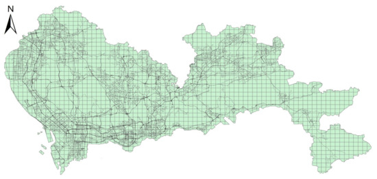
The rise of ride-hailing services presents innovative solutions for curbing urban carbon emissions, yet poses challenges such as fostering fair competition and integrating with public transit. Analyzing the factors influencing ride-hailing emissions is crucial for understanding their relationship with other travel modes and devising policies aimed at steering individuals towards more environmentally sustainable travel options. Therefore, this study delves into factors impacting ride-hailing emissions, including travel demand, land use, demographics, and transportation networks. It highlights the interplay among urban structure, multi-modal travel, and emissions, focusing on network features such as betweenness centrality and accessibility. Employing the COPERT (Computer Programme to Calculate Emissions from Road Transport) model, ride-hailing emissions are calculated from vehicle trajectory data. To mitigate statistical errors from multicollinearity, variable selection involves tests and correlation analysis. Geographically and temporally weighted regression (GTWR) with an adaptive kernel function is designed to understand key influencing mechanisms, overcoming traditional GTWR limitations. It can dynamically adjust bandwidth based on the spatio-temporal distribution of data points. Experiments in Shenzhen validate this approach, showing a 9.8% and 10.8% increase in explanatory power for weekday and weekend emissions, respectively, compared to conventional GTWR. The discussion of findings provides insights for urban planning and low-carbon transport strategies. Full article
Show Figures

Figure 1

2023

Jump to: 2024, 2022, 2021, 2020

12 pages, 1141 KiB  
Article
Fire Accident Risk Analysis of Lithium Battery Energy Storage Systems during Maritime Transportation
by Chunchang Zhang, Hu Sun, Yuanyuan Zhang, Gen Li, Shibo Li, Junyu Chang and Gongqian Shi
Sustainability 2023, 15(19), 14198; https://doi.org/10.3390/su151914198 - 26 Sep 2023
Cited by 7 | Viewed by 2009
Abstract
The lithium battery energy storage system (LBESS) has been rapidly developed and applied in engineering in recent years. Maritime transportation has the advantages of large volume, low cost, and less energy consumption, which is the main transportation mode for importing and exporting LBESS; [...] Read more.
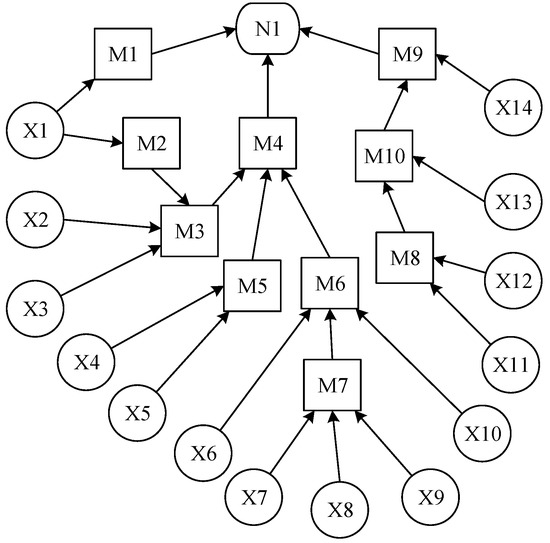
The lithium battery energy storage system (LBESS) has been rapidly developed and applied in engineering in recent years. Maritime transportation has the advantages of large volume, low cost, and less energy consumption, which is the main transportation mode for importing and exporting LBESS; nevertheless, a fire accident is the leading accident type in the transportation process of LBESS. This paper applied fault tree analysis and Bayesian network methods to evaluate the fire accident risk of LBESS in the process of maritime transportation. The Bayesian network was constructed via GeNIe 2.3 software, and the probability of LBESS fire accidents during maritime transportation was calculated based on the probability of basic events occurring. The results showed that an unsuitable firefighting system for putting out lithium battery fires, high humidity, and monitoring equipment without a real-time alarm function have the most significant influence on the occurrence of LBESS fire accidents during maritime transportation. The research work of this paper provides a theoretical basis for the risk assessment of LBESS during maritime transportation. Full article
Show Figures

Figure 1

20 pages, 6124 KiB  
Article
Distributed Traffic Control Based on Road Network Partitioning Using Normalization Algorithm
by Ke Ji, Jinjun Tang, Min Li and Cheng Hu
Sustainability 2023, 15(14), 11378; https://doi.org/10.3390/su151411378 - 21 Jul 2023
Cited by 2 | Viewed by 1605
Abstract
With continuous economic development, most urban road networks are facing unprecedented traffic congestion. Centralized traffic control is difficult to achieve, and distributed traffic control based on partitioning a road network into subnetworks is a promising way to alleviate traffic pressure on urban roads. [...] Read more.
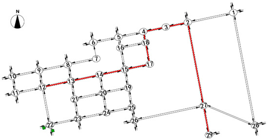
With continuous economic development, most urban road networks are facing unprecedented traffic congestion. Centralized traffic control is difficult to achieve, and distributed traffic control based on partitioning a road network into subnetworks is a promising way to alleviate traffic pressure on urban roads. In order to study the differences between different partitioning methods chosen for distributed traffic control, we used the normalization algorithm to partition a part of the road network in Changsha City, and we used the results of the Girvan–Newman algorithm and the manual empirical partitioning method as a control group. Meanwhile, an abstract road network was constructed using VISSIM simulation software based on realistic road network parameters. And then, the different partitioning results were applied to the simulated road network to analyze the control effect. The results of the simulation software show that different partitioning methods have different effects on traffic control at subnetwork boundaries and improve traffic pressure to different degrees. Partitioning the road network into four subnetworks provided the greatest degree of traffic improvement. Overall, the proposed distributed traffic control method effectively improved operational efficiency and alleviated the traffic pressure of the road network. Full article
Show Figures

Figure 1

14 pages, 3540 KiB  
Article
Wind Power Interval Prediction via an Integrated Variational Empirical Decomposition Deep Learning Model
by Shuling Zhao and Sishuo Zhao
Sustainability 2023, 15(7), 6114; https://doi.org/10.3390/su15076114 - 1 Apr 2023
Cited by 6 | Viewed by 1576
Abstract
As global demand for renewable energy increases, wind energy has become an important source of clean energy. However, due to the instability and unpredictability of wind energy, predicting wind power becomes one of the keys to resolving the instability of wind power. The [...] Read more.
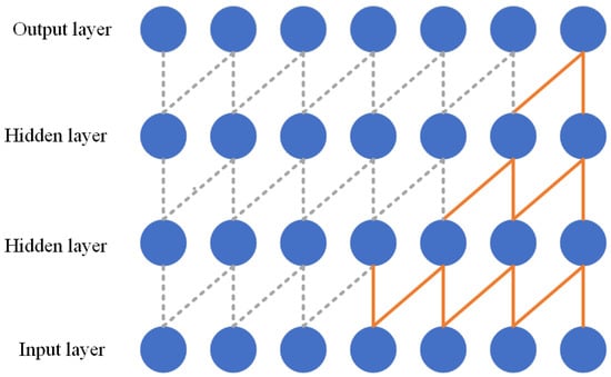
As global demand for renewable energy increases, wind energy has become an important source of clean energy. However, due to the instability and unpredictability of wind energy, predicting wind power becomes one of the keys to resolving the instability of wind power. The current point prediction model of wind power output has limitations and randomness in processing information. In order to improve the prediction accuracy and efficiency of wind power, a multi-step interval prediction method (VMD-TCN) is proposed in this article, which uses variational modal decomposition and an improved temporal convolutional network model to predict wind power. Additionally, it introduces attention mechanism, further improving the prediction performance of the model. The method first uses empirical mode decomposition to decompose the wind power generation sequence into six parts and obtains the trend, oscillation and noise components of the output power sequence; then, it optimizes the parameters of the six components, respectively, and uses the interval prediction method combined with the temporal convolutional network to construct a new power prediction model. Experiments show that the proposed method can effectively improve the prediction performance of the power prediction model, and it has strong robustness in interval prediction and high sensitivity to load changes, which can well help power system scheduling and new energy consumption. Full article
Show Figures

Figure 1

2022

Jump to: 2024, 2023, 2021, 2020

20 pages, 2542 KiB  
Article
Spatial Heterogeneity of the Recovery of Road Traffic Volume from the Impact of COVID-19: Evidence from China
by Jun Zhang, Shenghao Zhao, Chaonan Peng and Xianming Gong
Sustainability 2022, 14(21), 14297; https://doi.org/10.3390/su142114297 - 1 Nov 2022
Cited by 1 | Viewed by 1575
Abstract
The impact of COVID-19 on traffic volume makes it essential to study the spatial heterogeneity and impact mechanisms of the recovery of road traffic volume to promote the sustainability of related industries. As the research method, this study used a principal component analysis [...] Read more.
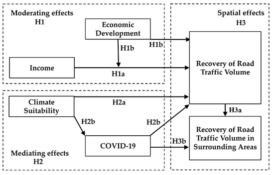
The impact of COVID-19 on traffic volume makes it essential to study the spatial heterogeneity and impact mechanisms of the recovery of road traffic volume to promote the sustainability of related industries. As the research method, this study used a principal component analysis to evaluate the recovery of road traffic volume in China quantitatively, and further conducted an empirical study using a spatial autocorrelation index and a dynamic spatial panel model. The results show that income has a negative impact on the recovery of road traffic volume, while climate suitability has a positive impact. Economic development and COVID-19 can play moderating and mediating effects, respectively. From the aspect of spatial heterogeneity, the recovery of road traffic volume has a positive spatial spillover effect on the surrounding provinces, while the spread of COVID-19 has a negative short-term indirect spatial spillover effect. Corresponding practical insights are provided for the stakeholders based on the above findings. The results of this study will contribute to the development of effective policies to facilitate the recovery of road traffic volume from the impact of COVID-19 and the revitalization of the transportation industry. Full article
Show Figures

Figure 1

24 pages, 2310 KiB  
Article
The Impacts of a COVID-19 Related Lockdown (and Reopening Phases) on Time Use and Mobility for Activities in Austria—Results from a Multi-Wave Combined Survey
by Lukas Hartwig, Reinhard Hössinger, Yusak Octavius Susilo and Astrid Gühnemann
Sustainability 2022, 14(12), 7422; https://doi.org/10.3390/su14127422 - 17 Jun 2022
Cited by 12 | Viewed by 2606
Abstract
When activity locations were shut down in the first lockdown to prevent the spread of COVID-19 in Austria, people reduced their trips accordingly. Based on a dataset obtained through a weeklong mobility and activity survey we analyse mobility and time use changes, as [...] Read more.
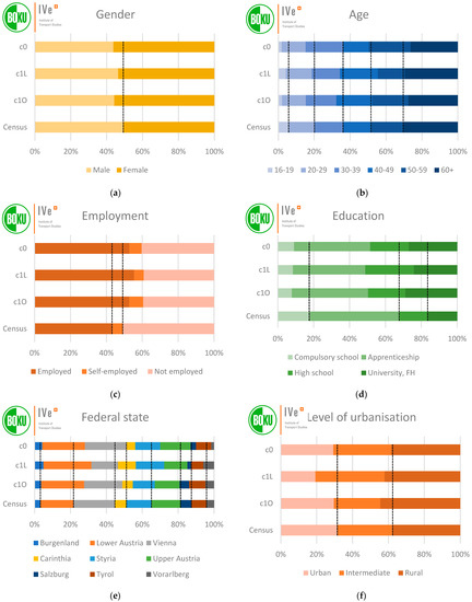
When activity locations were shut down in the first lockdown to prevent the spread of COVID-19 in Austria, people reduced their trips accordingly. Based on a dataset obtained through a weeklong mobility and activity survey we analyse mobility and time use changes, as well as changes in activity locations and secondary activities. Regression analysis is used to analyse differences in time use changes between socio-demographic groups. We show that trip rates and distances as well as public transport use dropped significantly during the lockdown and did not recover fully in the subsequent opening phase. Former travel time was used for additional leisure, sleep, domestic tasks, and eating in the lockdown, but only the latter two retained their increases in the opening phase. The lockdown resulted in a convergence of time use of socio-demographic groups with formerly different patterns, but the differences reappeared in the opening phase. Our findings are consistent with results from the literature but offer an integrated perspective on mobility and time use not found in either mobility- or time use-focussed studies. We conclude that there is a potential for trip reduction through a shift to virtual performance of activities, but the extent of this shift in post-pandemic times remains unclear. Full article
Show Figures

Figure 1

2021

Jump to: 2024, 2023, 2022, 2020

13 pages, 41427 KiB  
Article
Influence of Disinfectants on Airport Conveyor Belts
by Katarína Draganová, Karol Semrád, Monika Blišťanová, Tomáš Musil and Rastislav Jurč
Sustainability 2021, 13(19), 10842; https://doi.org/10.3390/su131910842 - 29 Sep 2021
Cited by 2 | Viewed by 1966
Abstract
The coronavirus disease has influenced almost all of our everyday activities. Traveling and transportation have been influenced significantly and there is no doubt that air transportation has been restricted and therefore reduced considerably. It is predicted that the change back to pre-pandemic conditions [...] Read more.
The coronavirus disease has influenced almost all of our everyday activities. Traveling and transportation have been influenced significantly and there is no doubt that air transportation has been restricted and therefore reduced considerably. It is predicted that the change back to pre-pandemic conditions will take several years, and so it is a reasonable assumption that disinfectants will be used more frequently for a long time. The presented article initially deals with the possible impacts of the pandemic on aircraft infrastructure—namely, on the influence of disinfectants on the rubber materials used, for example, in conveyor belts. The proposed methodology is based on the Weibull analysis for conveyor belt lifetime prediction regarding the impact of disinfectants. The Weibull distribution is a continuous probability distribution that can be applied as a theoretical model for statistical data processing. It was named after Weibull, who suggested shape, scale, and location parameters that made the distribution meaningful and useful. Currently, this distribution is applied in many areas, such as biology, economics, and hydrology. In engineering applications, it can be used for reliability and survival analysis. It is used mainly in cases where failure time is dependent on the operating hours, cycles, or age of the component. In the reliability area, it can be used, for example, to predict the lifetime or failure time of a component. To show the consequences of material changes due to the use of disinfectants, this article also presents a CAE (Computer Aided Engineering) analysis that was used for the evaluation of other hyperelastic material characteristics. This research is based on the results of experimental measurements, during which the influence of the types of disinfectant commonly used for the elimination of the coronavirus disease on airport conveyor belt rubber segments was tested. From the performed analysis, it was found that the influence of disinfectants on the material characteristics, including material hardness, elasticity, and static and dynamic loading, could be significant. Therefore, the probability of mechanical damage to the rubber part of the conveyor belt becomes higher, and time intervals for the maintenance or repair of airport conveyor belts should be considered. Full article
Show Figures

Figure 1

17 pages, 2012 KiB  
Article
Global Optimization Algorithm Based on Kriging Using Multi-Point Infill Sampling Criterion and Its Application in Transportation System
by Xiaodong Song, Mingyang Li, Zhitao Li and Fang Liu
Sustainability 2021, 13(19), 10645; https://doi.org/10.3390/su131910645 - 25 Sep 2021
Cited by 2 | Viewed by 2097
Abstract
Public traffic has a great influence, especially with the background of COVID-19. Solving simulation-based optimization (SO) problem is efficient to study how to improve the performance of public traffic. Global optimization based on Kriging (KGO) is an efficient method for SO; to this [...] Read more.
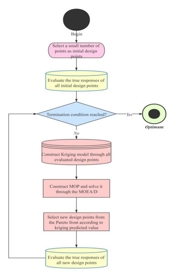
Public traffic has a great influence, especially with the background of COVID-19. Solving simulation-based optimization (SO) problem is efficient to study how to improve the performance of public traffic. Global optimization based on Kriging (KGO) is an efficient method for SO; to this end, this paper proposes a Kriging-based global optimization using multi-point infill sampling criterion. This method uses an infill sampling criterion which obtains multiple new design points to update the Kriging model through solving the constructed multi-objective optimization problem in each iteration. Then, the typical low-dimensional and high-dimensional nonlinear functions, and a SO based on 445 bus line in Beijing city, are employed to test the performance of our algorithm. Moreover, compared with the KGO based on the famous single-point expected improvement (EI) criterion and the particle swarm algorithm (PSO), our method can obtain better solutions in the same amount or less time. Therefore, the proposed algorithm expresses better optimization performance, and may be more suitable for solving the tricky and expensive simulation problems in real-world traffic problems. Full article
Show Figures

Figure 1

14 pages, 1443 KiB  
Article
Optimization Model of Regional Traffic Signs for Inducement at Road Works
by Lianzhen Wang, Han Zhang, Lingyun Shi, Qingling He and Huizhi Xu
Sustainability 2021, 13(13), 6996; https://doi.org/10.3390/su13136996 - 22 Jun 2021
Cited by 3 | Viewed by 1961
Abstract
A variety of pipelines are distributed under urban roads. The upgrading of pipelines is bound to occupy certain road resources, compress the driving space of motor vehicles for a long time, aggravate the traffic congestion in the construction section, and then affect the [...] Read more.
A variety of pipelines are distributed under urban roads. The upgrading of pipelines is bound to occupy certain road resources, compress the driving space of motor vehicles for a long time, aggravate the traffic congestion in the construction section, and then affect the traffic operation of the whole region. A reasonable layout of traffic signs for inducement to guide the traffic flow in the area where the construction section is located is conducive to promoting a balanced distribution of traffic flow in the regional road network, so as to achieve the reduction of automobile exhaust emissions and the sustainable development of traffic. In this paper, the layout optimization method of regional traffic signs for inducement is proposed. Taking the maximum amount of guidance information that the regional traffic signs can provide as the objective function, and taking the traffic volume, the characteristics of intersection nodes and the standard deviation of road saturation as the independent variables, the layout optimization model of guidance facilities is constructed, which can optimize the layout of traffic guidance signs in the area affected by the construction section, and achieve the goal that the minimum number of facilities can provide the maximum amount of guidance information. The results of the case study show that among the 64 alternative locations where traffic guidance signs can be set in the study area, eight optimal locations are finally determined as the setting points of guidance facilities through this model, and the effective increment of guidance information is the largest at this time. The model proposed in this paper can be used for reference to promote the sustainable development of traffic in the area where the construction section is located. Full article
Show Figures

Figure 1

16 pages, 4850 KiB  
Article
Vehicle Lane-Changing Safety Pre-Warning Model under the Environment of the Vehicle Networking
by Qiang Luo, Xiaodong Zang, Xu Cai, Huawei Gong, Jie Yuan and Junheng Yang
Sustainability 2021, 13(9), 5146; https://doi.org/10.3390/su13095146 - 4 May 2021
Cited by 13 | Viewed by 2632
Abstract
Lane-changing behavior is one of the most common driving behaviors while driving. Due to the complexity of its operation, vehicle collision accidents are prone to occur when changing lanes. Under the environment of vehicle networking, drivers can obtain more accurate traffic information in [...] Read more.
Lane-changing behavior is one of the most common driving behaviors while driving. Due to the complexity of its operation, vehicle collision accidents are prone to occur when changing lanes. Under the environment of vehicle networking, drivers can obtain more accurate traffic information in time, which can be of great help in terms of improving lane-changing safety. This paper analyzes the core factors that affect the safety of vehicles changing lanes, establishes the weight model of influencing factors of lane-changing behavior using the analytic hierarchy process (AHP), and obtains the calculation method of lane-changing behavior factors (LCBFs). Based on the fuzzy reasoning theory, the headway between the lane-changing vehicle and adjacent vehicles in the target lane was examined, and fuzzy logic lane-changing models were established for both situations (i.e., change to the left and change to the right lane). The fuzzy logic lane-changing models were tested via simulation experiments, and the test results showed that the models have a better warning effect on lane changing (LCBF = 1.5), with an accuracy of more than 90%. Thus, the established model in this paper can provide theoretical support for safety warnings when changing lanes and theoretical support for the sustainable development of transportation safety. Full article
Show Figures

Figure 1

16 pages, 4458 KiB  
Article
Analysis on Stability of Roadside Parking System in a Rail-Integrated Transport Hub
by Junheng Yang, Xiaodong Zang, Qiang Luo and Liming Shao
Sustainability 2021, 13(9), 4855; https://doi.org/10.3390/su13094855 - 26 Apr 2021
Cited by 1 | Viewed by 2543
Abstract
Roadside parking systems plays an important role in the planning and design of parking spaces, parking management and operation, and ensuring the safety of passengers. Firstly, we proposed a traffic wave theory and an avoidance logic algorithm to analyze the interaction mechanism of [...] Read more.
Roadside parking systems plays an important role in the planning and design of parking spaces, parking management and operation, and ensuring the safety of passengers. Firstly, we proposed a traffic wave theory and an avoidance logic algorithm to analyze the interaction mechanism of the roadside parking system in a rail-integrated transport hub. Moreover, we researched the evaluation indexes of the stability of roadside parking systems via two new concepts, namely static roadside parking time and dynamic roadside parking time. We found these improved the algorithm of the time utilization rate of the berth. Secondly, the coupling relationship between parking rate, delay and time utilization of berth was also discussed, and mathematical models of stability of the curb parking system were established. Furthermore, the feasibility of models was verified by multi-agent simulation through the VISSIM simulation platform. Finally, a new rail-integrated transport hub was taken as a practical case and studied alongside the simulation of the stability of curb parking system. Our study concluded that the curb parking system was ultimate stable when the time utilization rate was 37.5% and the parking rate was 91.2%. The results of these studies will provide theoretical support for designing curb parking berths in rail-integrated transport hubs. Full article
Show Figures

Figure 1

13 pages, 1677 KiB  
Article
Local Dynamic Path Planning for an Ambulance Based on Driving Risk and Attraction Field
by Fang Zong, Meng Zeng, Yang Cao and Yixuan Liu
Sustainability 2021, 13(6), 3194; https://doi.org/10.3390/su13063194 - 15 Mar 2021
Viewed by 2441
Abstract
Path planning is one of the most important aspects for ambulance driving. A local dynamic path planning method based on the potential field theory is presented in this paper. The potential field model includes two components—repulsive potential and attractive potential. Repulsive potential includes [...] Read more.
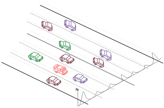
Path planning is one of the most important aspects for ambulance driving. A local dynamic path planning method based on the potential field theory is presented in this paper. The potential field model includes two components—repulsive potential and attractive potential. Repulsive potential includes road potential, lane potential and obstacle potential. Considering the driving distinction between an ambulance and a regular vehicle, especially in congested traffic, an adaptive potential function for a lane line is constructed in association with traffic conditions. The attractive potential is constructed with target potential, lane-velocity potential and tailgating potential. The design of lane-velocity potential is to characterize the influence of velocity on other lanes so as to prevent unnecessary lane-changing behavior for the sake of time-efficiency. The results obtained from simulation demonstrate that the proposed method yields a good performance for ambulance driving in an urban area, which can provide support for designing an ambulance support system for the ambulance personnel and dispatcher. Full article
Show Figures

Figure 1

24 pages, 3274 KiB  
Perspective
Insight into the Impact of COVID-19 on Australian Transportation Sector: An Economic and Community-Based Perspective
by Hafiz Suliman Munawar, Sara Imran Khan, Zakria Qadir, Abbas Z. Kouzani and M A Parvez Mahmud
Sustainability 2021, 13(3), 1276; https://doi.org/10.3390/su13031276 - 26 Jan 2021
Cited by 75 | Viewed by 18828
Abstract
The Coronavirus Disease 2019 (COVID-19) is a major virus outbreak of the 21st century. The Australian government and local authorities introduced some drastic strategies and policies to control the outspread of this virus. The policies related to lockdown, quarantine, social distancing, shut down [...] Read more.
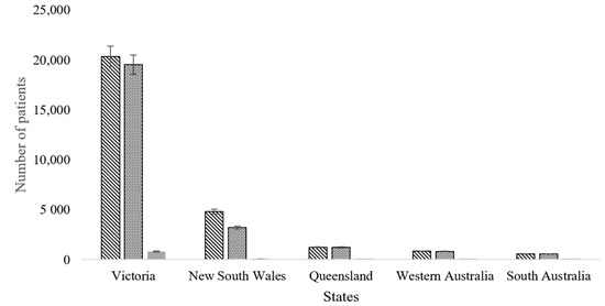
The Coronavirus Disease 2019 (COVID-19) is a major virus outbreak of the 21st century. The Australian government and local authorities introduced some drastic strategies and policies to control the outspread of this virus. The policies related to lockdown, quarantine, social distancing, shut down of educational institute, work from home, and international and interstate travel bans significantly affect the lifestyle of citizens and, thus, influence their activity patterns. The transport system is, thus, severely affected due to the COVID-19 related restrictions. This paper analyses how the transport system is impacted because of the policies adopted by the Australian government for the containment of the COVID-19. Three main components of the transport sector are studied. These are air travel, public transport, and freight transport. Various official sources of data such as the official website of the Australian government, Google mobility trends, Apple Mobility trends, and Moovit were consulted along with recently published research articles on COVID-19 and its impacts. The secondary sources of data include databases, web articles, and interviews that were conducted with the stakeholders of transport sectors in Australia to analyse the relationship between COVID-19 prevention measures and the transport system. The results of this study showed reduced demand for transport with the adoption of COVID-19 prevention measures. Declines in revenues in the air, freight, and public transport sectors of the transport industry are also reported. The survey shows that transport sector in Australia is facing a serious financial downfall as the use of public transport has dropped by 80%, a 31.5% drop in revenues earned by International airlines in Australia has been predicted, and a 9.5% reduction in the freight transport by water is expected. The recovery of the transport sector to the pre-pandemic state is only possible with the relaxation of COVID-19 containment policies and financial support by the government. Full article
Show Figures

Figure 1

20 pages, 10495 KiB  
Article
Transmission Path Tracking of Maritime COVID-19 Pandemic via Ship Sailing Pattern Mining
by Hailin Zheng, Qinyou Hu, Chun Yang, Jinhai Chen and Qiang Mei
Sustainability 2021, 13(3), 1089; https://doi.org/10.3390/su13031089 - 21 Jan 2021
Cited by 10 | Viewed by 2905
Abstract
Since the spread of the coronavirus disease 2019 (COVID-19) pandemic, the transportation of cargo by ship has been seriously impacted. In order to prevent and control maritime COVID-19 transmission, it is of great significance to track and predict ship sailing behavior. As the [...] Read more.
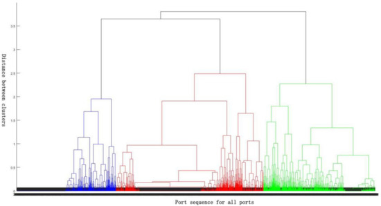
Since the spread of the coronavirus disease 2019 (COVID-19) pandemic, the transportation of cargo by ship has been seriously impacted. In order to prevent and control maritime COVID-19 transmission, it is of great significance to track and predict ship sailing behavior. As the nodes of cargo ship transportation networks, ports of call can reflect the sailing behavior of the cargo ship. Accurate hierarchical division of ports of call can help to clarify the navigation law of ships with different ship types and scales. For typical cargo ships, ships with deadweight over 10,000 tonnages account for 95.77% of total deadweight, and 592,244 berthing ships’ records were mined from automatic identification system (AIS) from January to October 2020. Considering ship type and ship scale, port hierarchy classification models are constructed to divide these ports into three kinds of specialized ports, including bulk, container, and tanker ports. For all types of specialized ports (considering ship scale), port call probability for corresponding ship type is higher than other ships, positively correlated with the ship deadweight if port scale is bigger than ship scale, and negatively correlated with the ship deadweight if port scale is smaller than ship scale. Moreover, port call probability for its corresponding ship type is positively correlated with ship deadweight, while port call probability for other ship types is negatively correlated with ship deadweight. Results indicate that a specialized port hierarchical clustering algorithm can divide the hierarchical structure of typical cargo ship calling ports, and is an effective method to track the maritime transmission path of the COVID-19 pandemic. Full article
Show Figures

Figure 1

14 pages, 711 KiB  
Article
Exploring the Impact of Climate and Extreme Weather on Fatal Traffic Accidents
by Yajie Zou, Yue Zhang and Kai Cheng
Sustainability 2021, 13(1), 390; https://doi.org/10.3390/su13010390 - 4 Jan 2021
Cited by 42 | Viewed by 7510
Abstract
Climate change and the extreme weather have a negative impact on road traffic safety, resulting in severe road traffic accidents. In this study, a negative binomial model and a log-change model are proposed to analyse the impact of various factors on fatal traffic [...] Read more.
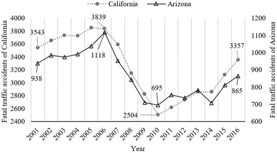
Climate change and the extreme weather have a negative impact on road traffic safety, resulting in severe road traffic accidents. In this study, a negative binomial model and a log-change model are proposed to analyse the impact of various factors on fatal traffic accidents. The dataset used in this study includes the fatal traffic accident frequency, social development indicators and climate indicators in California and Arizona. The results show that both models can provide accurate fitting results. Climate variables (i.e., average temperature and standard precipitation 24) can significantly affect the frequency of fatal traffic accidents. Non-climate variables (i.e., beer consumption, rural Vehicle miles travelled ratio, and vehicle performance) also have a significant impact. The modelling results can provide decision-making guidelines for the transportation management agencies to improve road traffic safety. Full article
Show Figures

Figure 1

2020

Jump to: 2024, 2023, 2022, 2021

17 pages, 2217 KiB  
Article
Risk Reasoning from Factor Correlation of Maritime Traffic under Arctic Sea Ice Status Association with a Bayesian Belief Network
by Zhuang Li, Shenping Hu, Guoping Gao, Yongtao Xi, Shanshan Fu and Chenyang Yao
Sustainability 2021, 13(1), 147; https://doi.org/10.3390/su13010147 - 25 Dec 2020
Cited by 23 | Viewed by 3077
Abstract
Sustainable growth should not only be beneficial to the shipping industry in the future, but is also an urgent need to respond to resource and environmental crises and strengthen shipping governance. Maritime traffic in Arctic waters is prone to encounter dangerous ice conditions, [...] Read more.
Sustainable growth should not only be beneficial to the shipping industry in the future, but is also an urgent need to respond to resource and environmental crises and strengthen shipping governance. Maritime traffic in Arctic waters is prone to encounter dangerous ice conditions, and it is essential to study the mechanism of ice collision risk formation in relation to ice conditions. Taking the ship-ice collision risk in Arctic waters as the research object, we propose a dynamic assessment model of ship-ice collision risk under sea ice status dynamic association (SDA) effect. By constructing the standard paradigm of risk factor dynamic association (DA) effect, taking SDA as the key association factor. Combing with other risk factors that affect ship-ice collision accidents, the coupling relationship between risk factors were analyzed. Then, using the Bayesian network method to build a ship-ice collision accident dynamic risk assessment model and combing with the ice monitoring data in summer Arctic waters, we screen five ships’ position information on the trans-Arctic route in August. The risk behavior of ship-ice collision accidents on the selected route under SDA is analyzed by model simulation. The research reveal that the degree of SDA is a key related factor for the serious ice condition and the possibility of human error during ship’s navigation, which significantly affects the ship-ice collision risk. The traffic in Arctic waters requires extra vigilance of the SDA effect from no ice threat to ice threat, and continuous ice threat. According to the ship-ice collision risk analysis under the SDA effect and without SDA effect, the difference in risk reasoning results on the five stations of the selected route are 32.69%, −32.33%, −27.64%, −10.26%, and −30.13% respectively. The DA effect can optimize ship-ice collision risk inference problem in Arctic waters. Full article
Show Figures

Figure 1

23 pages, 9399 KiB  
Article
Measuring Accessibility Based on Improved Impedance and Attractive Functions Using Taxi Trajectory Data
by Helai Huang, Jialing Wu, Fang Liu and Yiwei Wang
Sustainability 2021, 13(1), 112; https://doi.org/10.3390/su13010112 - 24 Dec 2020
Cited by 7 | Viewed by 2930
Abstract
Accessibility has attracted wide interest from urban planners and transportation engineers. It is an important indicator to support the development of sustainable policies for transportation systems in major events, such as the COVID-19 pandemic. Taxis are a vital travel mode in urban areas [...] Read more.
Accessibility has attracted wide interest from urban planners and transportation engineers. It is an important indicator to support the development of sustainable policies for transportation systems in major events, such as the COVID-19 pandemic. Taxis are a vital travel mode in urban areas that provide door-to-door services for individuals to perform urban activities. This study, with taxi trajectory data, proposes an improved method to evaluate dynamic accessibility depending on traditional location-based measures. A new impedance function is introduced by taking characteristics of the taxi system into account, such as passenger waiting time and the taxi fare rule. An improved attraction function is formulated by considering dynamic availability intensity. Besides, we generate five accessibility scenarios containing different indicators to compare the variation of accessibility. A case study is conducted with the data from Shenzhen, China. The results show that the proposed method found reduced urban accessibility, but with a higher value in southern center areas during the evening peak period due to short passenger waiting time and high destination attractiveness. Each spatio-temporal indicator has an influence on the variation in accessibility. Full article
Show Figures

Figure 1

12 pages, 1782 KiB  
Article
Data-Driven Approach to Understand the Mobility Patterns of the Portuguese Population during the COVID-19 Pandemic
by Tiago Tamagusko and Adelino Ferreira
Sustainability 2020, 12(22), 9775; https://doi.org/10.3390/su12229775 - 23 Nov 2020
Cited by 33 | Viewed by 5987
Abstract
SARS-CoV-2 emerged in late 2019. Since then, it has spread to several countries, becoming classified as a pandemic. So far, there is no definitive treatment or vaccine, so the best solution is to prevent transmission between individuals through social distancing. However, it is [...] Read more.
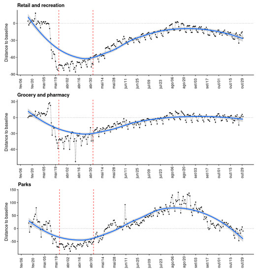
SARS-CoV-2 emerged in late 2019. Since then, it has spread to several countries, becoming classified as a pandemic. So far, there is no definitive treatment or vaccine, so the best solution is to prevent transmission between individuals through social distancing. However, it is not easy to measure the effectiveness of these distance measures. Therefore, this study uses data from Google COVID-19 Community Mobility Reports to understand the Portuguese population’s mobility patterns during the COVID-19 pandemic. In this study, the Rt value was modeled for Portugal. In addition, the changepoint was calculated for the population mobility patterns. Thus, the mobility pattern change was used to understand the impact of social distance measures on the dissemination of COVID-19. As a result, it can be stated that the initial Rt value in Portugal was very close to 3, falling to values close to 1 after 25 days. Social isolation measures were adopted quickly. Furthermore, it was observed that public transport was avoided during the pandemic. Finally, until the emergence of a vaccine or an effective treatment, this is the new normal, and it must be understood that new patterns of mobility, social interaction, and hygiene must be adapted to this reality. Full article
Show Figures

Figure 1

Back to TopTop