Next Issue
Volume 7, January
Previous Issue
Volume 6, September


J. Mar. Sci. Eng., Volume 6, Issue 4 (December 2018) – 52 articles

Cover Story (view full-size image): 
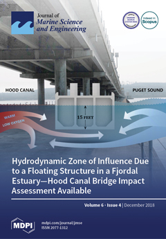
A floating bridge across the mouth of the narrow fjord-like waterbody of Hood Canal, Washington impacts water quality parameters and creates a migration barrier for surface-oriented fish species. The bridge floats on concrete pontoons, which span 85% of the width of the canal and extend several meters into the water column. Three-dimensional hydrodynamic models of Hood Canal, validated by an intensive field data collection program, show that the pontoons obstruct the brackish outflow surface layer, causing increased local mixing and up-current pooling/down-current sheltering during ebb and flood tidal exchange. This physical obstruction within the upper water column alters temperature, salinity, and current velocity near the bridge. The cover image shows the Hood Canal Bridge infrastructure within the waterbody and demonstrates the pooling/sheltering effects of the physical barrier. View this paper.
  • Issues are regarded as officially published after their release is announced to the table of contents alert mailing list.
  • You may sign up for e-mail alerts to receive table of contents of newly released issues.
  • PDF is the official format for papers published in both, html and pdf forms. To view the papers in pdf format, click on the "PDF Full-text" link, and use the free Adobe Reader to open them.
Order results
Result details
Section
Select all
Export citation of selected articles as:
23 pages, 10660 KiB  
Article
Lateral Circulation in a Partially Stratified Tidal Inlet
by Linlin Cui, Haosheng Huang, Chunyan Li and Dubravko Justic
J. Mar. Sci. Eng. 2018, 6(4), 159; https://doi.org/10.3390/jmse6040159 - 19 Dec 2018
Cited by 11 | Viewed by 3281
Abstract
Using a three-dimensional, hydrostatic, primitive-equation ocean model, this study investigates the dynamics of lateral circulation in a partially stratified tidal inlet, the Barataria Pass in the Gulf of Mexico, over a 25.6 h diurnal tidal cycle. Model performance is assessed against observational data. [...] Read more.
Using a three-dimensional, hydrostatic, primitive-equation ocean model, this study investigates the dynamics of lateral circulation in a partially stratified tidal inlet, the Barataria Pass in the Gulf of Mexico, over a 25.6 h diurnal tidal cycle. Model performance is assessed against observational data. During flood tide, the lateral circulation exhibits the characteristics similar to those induced by differential advection, i.e., lateral flow consists of two counter-rotating cells and is convergent at the surface. The analysis of momentum balance indicates that, in addition to the pressure gradient and vertical stress divergence, nonlinear advection and horizontal stress divergence are also important contributors. During ebb phase, the lateral circulation is mostly toward the right shoal (when looking into the estuary) for the whole water column and persisting for almost the whole period. The surface divergence suggested by the differential advection mechanism lasts for a very short period, if it ever exists. The main momentum balance across most of the transect during ebb is between the along-channel advection of cross-channel momentum and pressure gradient. The sectional averaged lateral velocity magnitude during ebb is comparable to that during flood, which is different from the idealized numerical experiment result. Full article
Show Figures

Figure 1

26 pages, 5112 KiB  
Article
Storm Surge Propagation and Flooding in Small Tidal Rivers during Events of Mixed Coastal and Fluvial Influence
by Liv Herdman, Li Erikson and Patrick Barnard
J. Mar. Sci. Eng. 2018, 6(4), 158; https://doi.org/10.3390/jmse6040158 - 17 Dec 2018
Cited by 29 | Viewed by 5527
Abstract
The highly urbanized estuary of San Francisco Bay is an excellent example of a location susceptible to flooding from both coastal and fluvial influences. As part of developing a forecast model that integrates fluvial and oceanic drivers, a case study of the Napa [...] Read more.
The highly urbanized estuary of San Francisco Bay is an excellent example of a location susceptible to flooding from both coastal and fluvial influences. As part of developing a forecast model that integrates fluvial and oceanic drivers, a case study of the Napa River and its interactions with the San Francisco Bay was performed. For this application we utilize Delft3D-FM, a hydrodynamic model that computes conservation of mass and momentum on a flexible mesh grid, to calculate water levels that account for tidal forcing, storm surge generated by wind and pressure fields, and river flows. We simulated storms with realistic atmospheric pressure, river discharge, and tidal forcing to represent a realistic joint fluvial and coastal storm event. Storm conditions were applied to both a realistic field-scale Napa river drainage as well as an idealized geometry. With these scenarios, we determine how the extent, level, and duration of flooding is dependent on these atmospheric and hydrologic parameters. Unsurprisingly, the model indicates that maximal water levels will occur in a tidal river when high tides, storm surge, and large fluvial discharge events are coincident. Model results also show that large tidal amplitudes diminish storm surge propagation upstream and that phasing between peak fluvial discharges and high tide is important for predicting when and where the highest water levels will occur. The interactions between tides, river discharge, and storm surge are not simple, indicating the need for more integrated flood forecasting models in the future. Full article
Show Figures

Figure 1

16 pages, 1255 KiB  
Article
Towards Age Determination of Southern King Crab (Lithodes santolla) Off Southern Chile Using Flexible Mixture Modeling
by Javier E. Contreras-Reyes, Freddy O. López Quintero and Alejandro A. Yáñez
J. Mar. Sci. Eng. 2018, 6(4), 157; https://doi.org/10.3390/jmse6040157 - 14 Dec 2018
Cited by 8 | Viewed by 2998
Abstract
This study addresses the problem of age determination of the southern king crab (Lithodes santolla). Given that recapture is difficult for this species and, thus, age cannot be directly determined with the help of the annual marks on the shell, the [...] Read more.
This study addresses the problem of age determination of the southern king crab (Lithodes santolla). Given that recapture is difficult for this species and, thus, age cannot be directly determined with the help of the annual marks on the shell, the von Bertalanffy growth function (vBGF) cannot be used to directly model length-frequency data (LFD). To determine age classes, some researchers have proposed using the MIX algorithm that consists of sampling realization of a finite mixture of normal (FMN) distributions for each LFD. However, normality assumption in age-length data has been questioned in several works related to fish growth analysis. For this study, we considered the biological information of the southern king crab for the period 2007–2015 and localization between 50 06 53 15 S and 76 36 72 18 W. We assumed that LFD could be modelled by the novel class of finite mixture of skew-t (FMST). Assigned age classes were used to estimate the vBGF parameters. The estimated vBGF parameters were L = 176.756 cm, K = 0.151 year 1 , t 0 = 1.678 year for males, and L = 134.799 cm, K = 0.220 year 1 , t 0 = 1.302 year for females. This study concludes that (a) FMST modal decomposition can detect a group of younger individuals at age 2, given that those individuals have LFD with a left heavy-tail and asymmetry; (b) FMST produces a better representation of LFD than the FMN model; (c) males have bigger L but grow slower than females; and (d) as expected, a high correlation exists among the vBGF estimates. Full article
(This article belongs to the Section Marine Biology)
Show Figures

Figure 1

17 pages, 4273 KiB  
Article
Wave Impact Pressures on Stepped Revetments
by Nils B. Kerpen, Talia Schoonees and Torsten Schlurmann
J. Mar. Sci. Eng. 2018, 6(4), 156; https://doi.org/10.3390/jmse6040156 - 13 Dec 2018
Cited by 5 | Viewed by 3313
Abstract
The wave impacts on horizontal and vertical step fronts of stepped revetments is investigated by means of hydraulic model tests conducted with wave spectra in a wave flume. Wave impacts on revetments with relative step heights of 0.3 < Hm0/ [...] Read more.
The wave impacts on horizontal and vertical step fronts of stepped revetments is investigated by means of hydraulic model tests conducted with wave spectra in a wave flume. Wave impacts on revetments with relative step heights of 0.3 < Hm0/Sh < 3.5 and a constant slope of 1:2 are analyzed with respect to (1) the probability distribution of the impacts, (2) the time evolution of impacts including a classification of load cases, and (3) a special distribution of the position of the maximum impact. The validity of the approved log-normal probability distribution for the largest wave impacts is experimentally verified for stepped revetments. The wave impact properties for stepped revetments are compared with those of vertical seawalls, showing that their impact rising times are within the same range. The impact duration for stepped revetments is shorter and decreases with increasing step height. Maximum horizontal wave impact loads are about two times larger than the corresponding maximum vertical wave impact loads. Horizontal and vertical impact loads increase with a decreasing step height. Data are compared with findings from literature for stepped revetments and vertical walls. A prediction formula is provided to calculate the maximum horizontal wave impact at stepped revetments along its vertical axis. Full article
(This article belongs to the Special Issue Selected Papers from Coastlab18 Conference)
Show Figures

Figure 1

14 pages, 3005 KiB  
Article
On Air-Cavity Formation during Water Entry of Flexible Wedges
by Riccardo Panciroli, Tiziano Pagliaroli and Giangiacomo Minak
J. Mar. Sci. Eng. 2018, 6(4), 155; https://doi.org/10.3390/jmse6040155 - 12 Dec 2018
Cited by 11 | Viewed by 3860
Abstract
Elastic bodies entering water might experience fluid–structure interaction phenomena introduced by the mutual interaction between structural deformation and fluid motion. Cavity formation, often misleadingly named cavitation, is one of these. This work presents the results of an experimental investigation on the water entry [...] Read more.
Elastic bodies entering water might experience fluid–structure interaction phenomena introduced by the mutual interaction between structural deformation and fluid motion. Cavity formation, often misleadingly named cavitation, is one of these. This work presents the results of an experimental investigation on the water entry of deformable wedges impacting a quiescent water surface with pure vertical velocity in free fall. The experimental campaign is conducted on flexible wedges parametrically varying the flexural stiffness, deadrise angle, and drop height. It is found that, under given experimental conditions, cavity pockets form beneath the wedge. Their generation mechanism might be ascribed to a differential between structural and fluid velocities, which is introduced by structural vibrations. Results show that the impact force during water entry of stiff wedges are always opposing gravity, while, in case flexible wedges temporarily reverse their direction, with the body that is being sucked into the water within the time frame between the cavity formation and its collapse. Severe impact might also generate a series of cavity generation and collapses. Full article
(This article belongs to the Special Issue Engineering Mathematics in Ship Design)
Show Figures

Figure 1

16 pages, 4291 KiB  
Article
A 2D Tide-Averaged Model for the Long-Term Evolution of an Idealized Tidal Basin-Inlet-Delta System
by Giulio Mariotti and Shamim Murshid
J. Mar. Sci. Eng. 2018, 6(4), 154; https://doi.org/10.3390/jmse6040154 - 11 Dec 2018
Cited by 11 | Viewed by 4242
Abstract
We present a model for the morphodynamics of tidal basin-inlet-delta systems at the centennial time scales. Tidal flow is calculated through a friction dominated model, with a semi-empirical correction to account for the advection of momentum. Transport of non-cohesive sediment (sand) is simulated [...] Read more.
We present a model for the morphodynamics of tidal basin-inlet-delta systems at the centennial time scales. Tidal flow is calculated through a friction dominated model, with a semi-empirical correction to account for the advection of momentum. Transport of non-cohesive sediment (sand) is simulated through tidal dispersion, i.e., without explicitly resolving sediment advection. Sediment is also transported downslope through a bed elevation diffusion process. The model is compared to a high-resolution tide-resolving model (Delft3D) with good agreement for different hydrodynamic and sedimentary settings. The model has low sensitivity with respect to temporal and spatial discretization. For the same spatial resolution, the model is about five orders of magnitude faster than tide-resolving models (e.g., Delft3D), and about three orders of magnitude faster than tide-resolving models that use a morphological acceleration factor. This numerical efficiency makes the model suitable to assess long-term changes of large coastal areas. The model’s simplicity makes it suitable for coupling with other physical, ecological, and socio-economic dynamics. Full article
(This article belongs to the Special Issue Large-scale Coastal Behavior)
Show Figures

Figure 1

21 pages, 6243 KiB  
Article
Refined Analysis of RADARSAT-2 Measurements to Discriminate Two Petrogenic Oil-Slick Categories: Seeps versus Spills
by Gustavo de Araújo Carvalho, Peter J. Minnett, Eduardo Tavares Paes, Fernando Pellon De Miranda and Luiz Landau
J. Mar. Sci. Eng. 2018, 6(4), 153; https://doi.org/10.3390/jmse6040153 - 11 Dec 2018
Cited by 9 | Viewed by 2898
Abstract
Our research focuses on refining the ability to discriminate two petrogenic oil-slick categories: the sea surface expression of naturally-occurring oil seeps and man-made oil spills. For that, a long-term RADARSAT-2 dataset (244 scenes imaged between 2008 and 2012) is analyzed to investigate oil [...] Read more.
Our research focuses on refining the ability to discriminate two petrogenic oil-slick categories: the sea surface expression of naturally-occurring oil seeps and man-made oil spills. For that, a long-term RADARSAT-2 dataset (244 scenes imaged between 2008 and 2012) is analyzed to investigate oil slicks (4562) observed in the Gulf of Mexico (Campeche Bay, Mexico). As the scientific literature on the use of satellite-derived measurements to discriminate the oil-slick category is sparse, our research addresses this gap by extending our previous investigations aimed at discriminating seeps from spills. To reveal hidden traits of the available satellite information and to evaluate an existing Oil-Slick Discrimination Algorithm, distinct processing segments methodically inspect the data at several levels: input data repository, data transformation, attribute selection, and multivariate data analysis. Different attribute selection strategies similarly excel at the seep-spill differentiation. The combination of different Oil-Slick Information Descriptors presents comparable discrimination accuracies. Among 8 non-linear transformations, the Logarithm and Cube Root normalizations disclose the most effective discrimination power of almost 70%. Our refined analysis corroborates and consolidates our earlier findings, providing a firmer basis and useful accuracies of the seep-spill discrimination practice using information acquired with space-borne surveillance systems based on Synthetic Aperture Radars. Full article
(This article belongs to the Special Issue Marine Oil Spills 2018)
Show Figures

Figure 1

15 pages, 2173 KiB  
Article
Coastal Climate Adaptation Literatures of the Southeast and Northeast U.S.: Regional Comparisons among States and Document Sources
by Kenyon C. Lindeman, Christos Giannoulis and Bryce R. Beard
J. Mar. Sci. Eng. 2018, 6(4), 152; https://doi.org/10.3390/jmse6040152 - 11 Dec 2018
Cited by 1 | Viewed by 2660
Abstract
Challenges remain in optimizing the use of increasingly large inflows of climate adaptation articles and guidance documents to improve coastal science and engineering practices. In addition to four major academic databases, the large grey literature was quantified by analyzing web sources of hundreds [...] Read more.
Challenges remain in optimizing the use of increasingly large inflows of climate adaptation articles and guidance documents to improve coastal science and engineering practices. In addition to four major academic databases, the large grey literature was quantified by analyzing web sources of hundreds of government, nonprofit and university reports not previously included in reviews. Three spatial scales were examined for differences in amount and timing of adaptation documents: (a) between region (southeast and northeast U.S.); (b) among sub-region (Florida and Carolinas; New York/New Jersey and New England); and (c) among states (ten states total). Comparisons were also made across spatial scales for document sources (academic journals, government, non-governmental organizations (NGO), university, mixed sources), including four governance subcategories (federal, state, regional and local). Differences were identified among some spatial scales in academic vs. grey literature and among categories of grey literature. 53% of the literature was from grey sources (21% government, 10% university, 8% nonprofit and 14% mixed sources). This literature can be large and is grounded in applied, experiential knowledge, yet is unavailable in almost all academic databases. These relatively hidden documents provide insight into on-the-ground science and engineering case-histories, policy innovations, and power relationships across scales of geography and governance. Full article
(This article belongs to the Special Issue Coastal Zone Management)
Show Figures

Figure 1

20 pages, 3175 KiB  
Article
Linear Quadratic Optimal Control of a Spar-Type Floating Offshore Wind Turbine in the Presence of Turbulent Wind and Different Sea States
by Roberto Luiz Ramos
J. Mar. Sci. Eng. 2018, 6(4), 151; https://doi.org/10.3390/jmse6040151 - 07 Dec 2018
Cited by 10 | Viewed by 3000
Abstract
This paper presents the design of a linear quadratic (LQ) optimal controller for a spar-type floating offshore wind turbine (FOWT). The FOWT is exposed to different sea states and constant wind turbulence intensity above rated wind speed. A new LQ control objective is [...] Read more.
This paper presents the design of a linear quadratic (LQ) optimal controller for a spar-type floating offshore wind turbine (FOWT). The FOWT is exposed to different sea states and constant wind turbulence intensity above rated wind speed. A new LQ control objective is specified for the floater-turbine coupled control, in accordance with standard requirements, to reduce both rotor speed fluctuations and floater pitch motion in each relevant sea state compared with a baseline proportional-integral (PI) controller. The LQ weighting matrices are selected using time series of the wind/wave disturbances generated for the relevant sea states. A linearized state-space model is developed, including the floater surge/pitch motions, rotor speed, collective blade pitch actuation, and unmeasured environmental disturbances. The wind disturbance modeling is based on the Kaimal spectrum and aerodynamic thrust/torque coefficients. The wave disturbance modeling is based on the Pierson–Moskowitz spectrum and linearized Morison equation. A high-fidelity FOWT simulator is used to verify the control-oriented model. The simulation results for the OC3-Hywind FOWT subjected to turbulent wind show that a single LQ controller can yield both rotor speed fluctuation reduction of 32–72% and floater pitch motion reduction of 22–44% in moderate to very rough sea states compared with the baseline PI controller. Full article
(This article belongs to the Special Issue Advances in Offshore Wind Energy)
Show Figures

Figure 1

11 pages, 1957 KiB  
Article
Cubipod® Armor Design in Depth-Limited Regular Wave-Breaking Conditions
by M. Esther Gómez-Martín, María P. Herrera, Jose A. Gonzalez-Escriva and Josep R. Medina
J. Mar. Sci. Eng. 2018, 6(4), 150; https://doi.org/10.3390/jmse6040150 - 06 Dec 2018
Cited by 6 | Viewed by 2787
Abstract
Armor stability formulas for mound breakwaters are commonly based on 2D small-scale physical tests conducted in non-overtopping and non-breaking conditions. However, most of the breakwaters built around the world are located in breaking or partially-breaking wave conditions, where they must withstand design storms [...] Read more.
Armor stability formulas for mound breakwaters are commonly based on 2D small-scale physical tests conducted in non-overtopping and non-breaking conditions. However, most of the breakwaters built around the world are located in breaking or partially-breaking wave conditions, where they must withstand design storms having some percentage of large waves breaking before they reach the structure. In these cases, the design formulas for non-breaking wave conditions are not fully valid. This paper describes the specific 2D physical model tests carried out to analyze the trunk hydraulic stability of single- and double-layer Cubipod® armors in depth-limited regular wave breaking and non-overtopping conditions with horizontal foreshore (m = 0) and armor slope (α) with cotα = 1.5. An experimental methodology was established to ensure that 100 waves attacked the armor layer with the most damaging combination of wave height (H) and wave period (T) for the given water depth (hs). Finally, for a given water depth, empirical formulas were obtained to estimate the Cubipod® size which made the armor stable regardless of the deep-water wave storm. Full article
(This article belongs to the Special Issue Selected Papers from Coastlab18 Conference)
Show Figures

Figure 1

13 pages, 7345 KiB  
Article
Wave Overtopping over Coastal Structures with Oblique Wind and Swell Waves
by Ivo M. Van der Werf and Marcel R.A. Van Gent
J. Mar. Sci. Eng. 2018, 6(4), 149; https://doi.org/10.3390/jmse6040149 - 06 Dec 2018
Cited by 15 | Viewed by 3529
Abstract
Most guidelines on wave overtopping over coastal structures are based on conditions with waves from one direction only. Here, wave basin tests with oblique wave attack are presented where waves from one direction are combined with waves from another direction. This is especially [...] Read more.
Most guidelines on wave overtopping over coastal structures are based on conditions with waves from one direction only. Here, wave basin tests with oblique wave attack are presented where waves from one direction are combined with waves from another direction. This is especially important for locations where wind waves approach a coastal structure under a specific direction while swell waves approach the coastal structure under another direction. The tested structure was a dike with a smooth and impermeable 1:4 slope. The test programme consisted of four types of wave loading: (1) Wind waves only: “sea” (approaching the structure with an angle of 45°), (2) Wind waves and swell waves from the same direction (45°), (3) Wind waves and swell waves, simultaneously from two different directions (45° and −45°, thus perpendicular to each other), and (4) Wind waves, simultaneously from two different directions (45° and −45°, thus perpendicular to each other). Existing guidelines on wave overtopping have been extended to predict wave overtopping discharges under the mentioned types of wave loading (oblique sea and swell conditions). Full article
(This article belongs to the Special Issue Selected Papers from Coastlab18 Conference)
Show Figures

Figure 1

35 pages, 7678 KiB  
Article
Deciphering the Tsunami Wave Impact and Associated Connection Forces in Open-Girder Coastal Bridges
by Denis Istrati, Ian Buckle, Pedro Lomonaco and Solomon Yim
J. Mar. Sci. Eng. 2018, 6(4), 148; https://doi.org/10.3390/jmse6040148 - 05 Dec 2018
Cited by 64 | Viewed by 6932
Abstract
In view of the widespread damage to coastal bridges during recent tsunamis (2004 Indian Ocean and 2011 in Japan) large-scale hydrodynamic experiments of tsunami wave impact on a bridge with open girders were conducted in the Large Wave Flume at Oregon State University. [...] Read more.
In view of the widespread damage to coastal bridges during recent tsunamis (2004 Indian Ocean and 2011 in Japan) large-scale hydrodynamic experiments of tsunami wave impact on a bridge with open girders were conducted in the Large Wave Flume at Oregon State University. The main objective was to decipher the tsunami overtopping process and associated demand on the bridge and its structural components. As described in this paper, a comprehensive analysis of the experimental data revealed that: (a) tsunami bores introduce significant slamming forces, both horizontal (Fh) and uplift (Fv), during impact on the offshore girder and overhang; these can govern the uplift demand in connections; (b) maxFh and maxFv do not always occur at the same time and contrary to recommended practice the simultaneous application of maxFh and maxFv at the center of gravity of the deck does not yield conservative estimates of the uplift demand in individual connections; (c) the offshore connections have to withstand the largest percentage of the total induced deck uplift among all connections; this can reach 91% and 124% of maxFv for bearings and columns respectively, a finding that could explain the damage sustained by these connections and one that has not been recognized to date; (e) the generation of a significant overturning moment (OTM) at the initial impact when the slamming forces are maximized, which is the main reason for the increased uplift in the offshore connections; and (f) neither maxFv nor maxOTM coincide always with the maximum demand in each connection, suggesting the need to consider multiple combinations of forces with corresponding moments or with corresponding locations of application in order to identify the governing scenario for each structural component. In addition the paper presents “tsunami demand diagrams”, which are 2D envelopes of (Fh, Fv) and (OTM, Fv) and 3D envelopes of (Fh, Fv, OTM), as visual representations of the complex variation of the tsunami loading. Furthermore, the paper reveals the existence of a complex bridge inundation mechanism that consists of three uplift phases and one downward phase, with each phase maximizing the demand in different structural components. It then develops a new physics-based methodology consisting of three load cases, which can be used by practicing engineers for the tsunami design of bridge connections, steel bearings and columns. The findings in this paper suggest the need for a paradigm shift in the assessment of tsunami risk to coastal bridges to include not just the estimation of total tsunami load on a bridge but also the distribution of this load to individual structural components that are necessary for the survival of the bridge. Full article
(This article belongs to the Special Issue Tsunami Science and Engineering II)
Show Figures

Graphical abstract

8 pages, 1207 KiB  
Article
Determination of Cell Abundances and Paralytic Shellfish Toxins in Cultures of the Dinoflagellate Gymnodinium catenatum by Fourier Transform Near Infrared Spectroscopy
by Marta Belchior Lopes, Ana Amorim, Cecília Calado and Pedro Reis Costa
J. Mar. Sci. Eng. 2018, 6(4), 147; https://doi.org/10.3390/jmse6040147 - 05 Dec 2018
Cited by 5 | Viewed by 3504
Abstract
Harmful algal blooms are responsible worldwide for the contamination of fishery resources, with potential impacts on seafood safety and public health. Most coastal countries rely on an intense monitoring program for the surveillance of toxic algae occurrence and shellfish contamination. The present study [...] Read more.
Harmful algal blooms are responsible worldwide for the contamination of fishery resources, with potential impacts on seafood safety and public health. Most coastal countries rely on an intense monitoring program for the surveillance of toxic algae occurrence and shellfish contamination. The present study investigates the use of near infrared (NIR) spectroscopy for the rapid in situ determination of cell concentrations of toxic algae in seawater. The paralytic shellfish poisoning (PSP) toxin-producing dinoflagellate Gymnodinium catenatum was selected for this study. The spectral modeling by partial least squares (PLS) regression based on the recorded NIR spectra enabled the building of highly accurate (R2 = 0.92) models for cell abundance. The models also provided a good correlation between toxins measured by the conventional methods (high-performance liquid chromatography with fluorescence detection (HPLC-FLD)) and the levels predicted by the PLS/NIR models. This study represents the first necessary step in investigating the potential of application of NIR spectroscopy for algae bloom detection and alerting. Full article
(This article belongs to the Special Issue Advances and Current Challenges in Marine Biotoxins Monitoring)
Show Figures

Figure 1

12 pages, 3226 KiB  
Article
Anthropogenic and Natural Radiative Forcing: Positive Feedbacks
by Jean-Louis Pinault
J. Mar. Sci. Eng. 2018, 6(4), 146; https://doi.org/10.3390/jmse6040146 - 30 Nov 2018
Cited by 10 | Viewed by 5418
Abstract
This article is based on recent work intended to estimate the impact of solar forcing mediated by long-period ocean Rossby waves that are resonantly forced—the ‘Gyral Rossby Waves’ (GRWs). Here, we deduce both the part of the anthropogenic and climate components within the [...] Read more.
This article is based on recent work intended to estimate the impact of solar forcing mediated by long-period ocean Rossby waves that are resonantly forced—the ‘Gyral Rossby Waves’ (GRWs). Here, we deduce both the part of the anthropogenic and climate components within the instrumental surface temperature spatial patterns. The natural variations in temperature are estimated from a weighted sum of sea surface temperature anomalies in preselected areas of subtropical gyres representative of long-period GRWs. The temperature response to anthropogenic forcing is deduced by subtracting the climate component from the instrumental temperature. Depending on whether the inland regions are primarily impacted by latent or sensible heat fluxes from the oceans, positive feedbacks occur. This suggests that the lapse rate and the high troposphere cloud cover have a driving role in the amplification effect of anthropogenic climate forcing, while specifying the involved mechanisms. Full article
Show Figures

Figure 1

22 pages, 7052 KiB  
Article
An Assessment of Two Models of Wave Propagation in an Estuary Protected by Breakwaters
by Amin Ilia and James O'Donnell
J. Mar. Sci. Eng. 2018, 6(4), 145; https://doi.org/10.3390/jmse6040145 - 27 Nov 2018
Cited by 7 | Viewed by 5233
Abstract
Breakwaters influence coastal wave climate and circulation by blocking and dissipating wave energy. In a large harbor, these effects are combined with wave generation, refraction and reflection. Accurate representation of these processes is essential to the determination of coastal circulation and wave processes. [...] Read more.
Breakwaters influence coastal wave climate and circulation by blocking and dissipating wave energy. In a large harbor, these effects are combined with wave generation, refraction and reflection. Accurate representation of these processes is essential to the determination of coastal circulation and wave processes. MIKE21SW and SWAN are two third-generation spectral wave models which are used widely in coastal research and engineering applications. Recently improved versions of the models are able to consider the influence of breakwater structures. In this study, we used available observations to evaluate the accuracy of model simulations of waves in New Haven Harbor, Connecticut, USA, an estuary with three detached breakwaters near the mouth. The models were executed on their optimum unstructured triangular grid. The boundary conditions were derived from a bottom mounted Acoustic Doppler Current Profilers (ADCP) on the offshore side of the breakwaters. Wind forcing was applied using data from the Central Long Island Sound buoy. We found that both models were largely consistent with observations during storms. However, MIKE21SW predicted some of storm peaks slightly better. SWAN required the finer grid to achieve the optimum condition, but as it uses a fast, fully implicit algorithm, the computational times were similar. Also, the sensitivity analysis represents that wind forcing and the breakwaters have significant impact on the results. Full article
Show Figures

Figure 1

17 pages, 6120 KiB  
Article
Sediment Transport Model Including Short-Lived Radioisotopes: Model Description and Idealized Test Cases
by Justin J. Birchler, Courtney K. Harris, Christopher R. Sherwood and Tara A. Kniskern
J. Mar. Sci. Eng. 2018, 6(4), 144; https://doi.org/10.3390/jmse6040144 - 27 Nov 2018
Cited by 1 | Viewed by 3156
Abstract
Geochronologies derived from sediment cores in coastal locations are often used to infer event bed characteristics such as deposit thicknesses and accumulation rates. Such studies commonly use naturally occurring, short-lived radioisotopes, such as Beryllium-7 (7Be) and Thorium-234 (234Th), to [...] Read more.
Geochronologies derived from sediment cores in coastal locations are often used to infer event bed characteristics such as deposit thicknesses and accumulation rates. Such studies commonly use naturally occurring, short-lived radioisotopes, such as Beryllium-7 (7Be) and Thorium-234 (234Th), to study depositional and post-depositional processes. These radioisotope activities, however, are not generally represented in sediment transport models that characterize coastal flood and storm deposition with grain size patterns and deposit thicknesses. We modified the Community Sediment Transport Modeling System (CSTMS) to account for reactive tracers and used this capability to represent the behavior of these short-lived radioisotopes on the sediment bed. This paper describes the model and presents results from a set of idealized, one-dimensional (vertical) test cases. The model configuration represented fluvial deposition followed by periods of episodic storm resuspension. Sensitivity tests explored the influence on seabed radioisotope profiles by the intensities of bioturbation and wave resuspension and the thickness of fluvial deposits. The intensity of biodiffusion affected the persistence of fluvial event beds as evidenced by 7Be. Both resuspension and biodiffusion increased the modeled seabed inventory of 234Th. A thick fluvial deposit increased the seabed inventory of 7Be and 234Th but mixing over time greatly reduced the difference in inventory of 234Th in fluvial deposits of different thicknesses. Full article
Show Figures

Figure 1

13 pages, 4827 KiB  
Article
Hydraulic Stability of the Armor Layer of Overtopped Breakwaters
by Gloria Argente, M. Esther Gómez-Martín and Josep R. Medina
J. Mar. Sci. Eng. 2018, 6(4), 143; https://doi.org/10.3390/jmse6040143 - 27 Nov 2018
Cited by 15 | Viewed by 4622
Abstract
Mound breakwaters with significant overtopping rates in depth-limited conditions are common in practice due to social concern about the visual impact of coastal structures and sea level rise due to climatic change. For overtopped mound breakwaters, the highest waves pass over the crest [...] Read more.
Mound breakwaters with significant overtopping rates in depth-limited conditions are common in practice due to social concern about the visual impact of coastal structures and sea level rise due to climatic change. For overtopped mound breakwaters, the highest waves pass over the crest producing armor damage, not only to the front slope, but also to the crest and the rear slope. To guarantee the breakwater stability, it is necessary to limit the armor damage in the three parts of the structure: Front slope, crest, and rear slope. This paper describes the hydraulic stability of the armor layer of medium and low-crested structures in wave breaking conditions. Small-scale physical model tests were carried out with different relative crest freeboards and three armor units: Rocks, cubes, and Cubipods. The armor damage progression in the front slope, crest, and rear slope was analyzed using the Virtual Net method to consider the heterogeneous packing and porosity evolution along the armor slope. A comparison is provided between the hydraulic stability of the different armors and their relationship with the measured overtopping volumes. Full article
(This article belongs to the Special Issue Selected Papers from Coastlab18 Conference)
Show Figures

Figure 1

8 pages, 2112 KiB  
Article
Investigating the Pre-Damaged PZT Sensors under Impact Traction
by Sakineh Fotouhi, Mohamad Fotouhi, Ana Pavlovic and Nenad Djordjevic
J. Mar. Sci. Eng. 2018, 6(4), 142; https://doi.org/10.3390/jmse6040142 - 19 Nov 2018
Cited by 3 | Viewed by 3046
Abstract
Ships are usually under vibration, impact, and other kinds of static and dynamic loads. These loads arise from water flow across the hull or surfaces, the propeller cavitation, and so on. For optimal design purposes and reliable performance, experimental measurements are necessary. These [...] Read more.
Ships are usually under vibration, impact, and other kinds of static and dynamic loads. These loads arise from water flow across the hull or surfaces, the propeller cavitation, and so on. For optimal design purposes and reliable performance, experimental measurements are necessary. These sensors are often used under or near the water, working conditions that improve the risk of sensor damage. This paper aims at investigating, by the use of finite elements, the behavior of damaged piezoelectric sensors under traction and impact loads. The numerical method was calibrated using results available in the literature regarding piezoelectric and elastic plates with a central crack. After calibration, the simulation was used on two types of Lead-Zirconium-Titanium oxide (PZT) sandwich panel structures reinforced by aluminum skins. The results proved that the damage size and impact energy are important factors affecting the response of piezoelectric sensors; therefore, special attention might be considered when using these sensors for marine applications. Full article
(This article belongs to the Special Issue Engineering Mathematics in Ship Design)
Show Figures

Figure 1

4 pages, 171 KiB  
Editorial
Climate Change, Coasts and Coastal Risk
by Roshanka Ranasinghe and Ruben Jongejan
J. Mar. Sci. Eng. 2018, 6(4), 141; https://doi.org/10.3390/jmse6040141 - 19 Nov 2018
Cited by 5 | Viewed by 2938
Abstract
Projected climate change driven variations in mean sea level (i. [...] Full article
(This article belongs to the Special Issue Climate Change, Coasts and Coastal Risk)
23 pages, 13514 KiB  
Article
Detailed Hydrodynamic Feasibility Assessment for Leque Island and Zis a Ba Restoration Projects
by Adi Nugraha and Tarang Khangaonkar
J. Mar. Sci. Eng. 2018, 6(4), 140; https://doi.org/10.3390/jmse6040140 - 16 Nov 2018
Cited by 1 | Viewed by 2759
Abstract
Numerous restoration projects are underway in Puget Sound, Washington, USA with the goal of re-establishing intertidal wetlands that were historically lost due to dike construction for flood protection and agricultural development. One such effort is the restoration effort within the Stillaguamish Delta, benefitting [...] Read more.
Numerous restoration projects are underway in Puget Sound, Washington, USA with the goal of re-establishing intertidal wetlands that were historically lost due to dike construction for flood protection and agricultural development. One such effort is the restoration effort within the Stillaguamish Delta, benefitting from the cumulative effects from the Leque Island and zis a ba restoration projects. The preferred restoration design calls for the removal of perimeter dikes at the two sites and the creation of tidal channels to facilitate the drainage of tidal flows. A 3-D high-resolution unstructured-grid coastal ocean model based on FVCOM was developed to evaluate the hydrodynamic response of the estuary to restoration alternatives. A series of hydrodynamic modeling simulations were then performed to quantify the hydrodynamic response of the nearshore restoration project, such as periodic inundation, suitable currents, and desired habitat/salinity levels. Sediment impacts were also examined, including the potential for excessive erosion or sedimentation requiring maintenance. Simulation results indicate that the preferred alternative scenario provides the desired estuarine response, which is consistent with the planned design. A decrease in velocities and bed shear in the main river channels was noted for the restored condition associated with the increased inundation of tidal flat area and reduced tidal flows through the main channels. High bed shear near the restored tidal channel entrances indicates that the inlets may evolve in size until equilibrium is established. Full article
Show Figures

Figure 1

15 pages, 5854 KiB  
Article
A Sensitivity Analysis of the Wind Forcing Effect on the Accuracy of Large-Wave Hindcasting
by Taiping Wang, Zhaoqing Yang, Wei-Cheng Wu and Molly Grear
J. Mar. Sci. Eng. 2018, 6(4), 139; https://doi.org/10.3390/jmse6040139 - 14 Nov 2018
Cited by 22 | Viewed by 4000
Abstract
Deployment of wave energy converters (WECs) relies on consistent and accurate wave resource characterization, which is typically achieved through numerical modeling using deterministic wave models. The accurate predictions of large-wave events are critical to the success of wave resource characterization because of the [...] Read more.
Deployment of wave energy converters (WECs) relies on consistent and accurate wave resource characterization, which is typically achieved through numerical modeling using deterministic wave models. The accurate predictions of large-wave events are critical to the success of wave resource characterization because of the risk on WEC installation, maintenance, and damage caused by extreme sea states. Because wind forcing is the primary driver of wave models, the quality of wind data plays an important role in the accuracy of wave predictions. This study evaluates the sensitivity of large-wave prediction to different wind-forcing products, and identifies a feasible approach to improve wave model results through improved wind forcing. Using a multi-level nested-grid modeling approach, we perform a series of sensitivity tests at four representative National Data Buoy Center buoy locations on the U.S. East and West Coasts. The selected wind-forcing products include the Climate Forecast System Reanalysis global wind product and North American Regional Reanalysis regional wind product as well as the observed wind at the buoys. Sensitivity test results indicate a consistent improvement in model predictions for the large-wave events (e.g., >90th percentile of significant wave height) at all buoys when observed-wind data were used to drive the wave model simulations. Full article
Show Figures

Figure 1

17 pages, 21415 KiB  
Article
Using Argus Video Monitoring to Determine Limiting Factors of Aeolian Sand Transport on a Narrow Beach
by Pam Hage, Gerben Ruessink and Jasper Donker
J. Mar. Sci. Eng. 2018, 6(4), 138; https://doi.org/10.3390/jmse6040138 - 13 Nov 2018
Cited by 9 | Viewed by 3309
Abstract
Aeolian sediment transport on beaches is responsible for dune growth and/or recovery. Models predicting potential aeolian sediment transport rates often overpredict the amount of deposition on the foredune when applied to narrow (<100 m) beaches, pointing to supply limitations. Our goal is to [...] Read more.
Aeolian sediment transport on beaches is responsible for dune growth and/or recovery. Models predicting potential aeolian sediment transport rates often overpredict the amount of deposition on the foredune when applied to narrow (<100 m) beaches, pointing to supply limitations. Our goal is to better understand these limitations, especially in the long-term (>years) in order to improve predicted transport volumes and the timing of transport. Here, we used 8 years of Argus video images at Egmond aan Zee, The Netherlands, in combination with routine weather data to delineate 241 limited from 467 unlimited sand transport events to explore supply-limiting factors. Our research shows that the wind is more oriented to the west (shore normal) and is generally stronger for limited transport events. This indicates that the available fetch distance is often less than the critical fetch needed for unlimited transport. This is further confirmed by the timing of the transport events, as limited events often became unlimited during low tide when the beach was the widest and fetch potentially the longest. Our results help understanding the nature of aeolian sediment transport on narrow beaches, which will hopefully lead to better predictions of annual aeolian sediment transport rates. Full article
(This article belongs to the Special Issue Coastal Dune Dynamics and Management)
Show Figures

Figure 1

18 pages, 6965 KiB  
Article
Water Quality Model Calibration via a Full-Factorial Analysis of Algal Growth Kinetic Parameters
by James D. Bowen and Noyes B. Harrigan
J. Mar. Sci. Eng. 2018, 6(4), 137; https://doi.org/10.3390/jmse6040137 - 12 Nov 2018
Cited by 4 | Viewed by 2852
Abstract
The two-dimensional, laterally-averaged mechanistic eutrophication model CE-QUAL-W2 version 3.72 was used to predict chlorophyll-a concentrations across two different time periods in the Neuse River Estuary, North Carolina. Chlorophyll calibration was performed for two time periods simultaneously by performing a full-factorial experiment that tested [...] Read more.
The two-dimensional, laterally-averaged mechanistic eutrophication model CE-QUAL-W2 version 3.72 was used to predict chlorophyll-a concentrations across two different time periods in the Neuse River Estuary, North Carolina. Chlorophyll calibration was performed for two time periods simultaneously by performing a full-factorial experiment that tested seven algal kinetic growth parameters over three levels for a single algal group. A cluster of up to six computers each running between two and ten instances of the program was used to complete and manage the data for 2187 runs for each period. Six numeric criteria were used to determine which runs performed acceptably, yielding a group of 27 cases that met all of the criteria. Calibration performance of the set of cases outperformed a previously calibrated model using three algal groups that met only four of the six selection criteria. Calibration performed this way allowed for a more rational specification of model calibration performance and provided uncertainty estimates of model predictions, albeit at the cost of a considerable increase in computational requirements that necessitated the use of a computer cluster. Full article
Show Figures

Figure 1

19 pages, 9695 KiB  
Article
A Validation of Symmetric 2D + T Model Based on Single-Stepped Planing Hull Towing Tank Tests
by Rasul Niazmand Bilandi, Simone Mancini, Luigi Vitiello, Salvatore Miranda and Maria De Carlini
J. Mar. Sci. Eng. 2018, 6(4), 136; https://doi.org/10.3390/jmse6040136 - 12 Nov 2018
Cited by 17 | Viewed by 5070
Abstract
In the current article, the hydrodynamic forces of single-stepped planing hulls were evaluated by an analytical method and compared against towing tank tests. Using the 2D + T theory, the pressure distribution over the wedge section entering the water and the normal forces [...] Read more.
In the current article, the hydrodynamic forces of single-stepped planing hulls were evaluated by an analytical method and compared against towing tank tests. Using the 2D + T theory, the pressure distribution over the wedge section entering the water and the normal forces acting on the 2D sections have been computed. By integrating the 2D sectional normal forces over the entire wetted length of the vessel, the lift force acting on it has been obtained. Using lift forces as well as the consequence pitch moment, the equilibrium condition for the single-stepped planing hull is found and then resistance, dynamic trim, and the wetted surface are computed. The obtained hydrodynamic results have been compared against the experimental data and it has been observed that the presented mathematical model has reasonable accuracy, in particular, up to Froude number 2.0. Furthermore, this mathematical model can be a useful and fast tool for the stepped hull designers in the early design stage in order to compare the different hull configurations. It should also be noted that the mathematical model has been developed in such a way that it has the potential to model the sweep-back step and transverse the vertical motions of single-stepped planing hulls in future studies. Full article
(This article belongs to the Special Issue Engineering Mathematics in Ship Design)
Show Figures

Figure 1

24 pages, 6772 KiB  
Article
Model Development and Hindcast Simulations of NOAA’s Integrated Northern Gulf of Mexico Operational Forecast System
by Zizang Yang, Lianyuan Zheng, Phillip Richardson, Edward Myers and Aijun Zhang
J. Mar. Sci. Eng. 2018, 6(4), 135; https://doi.org/10.3390/jmse6040135 - 12 Nov 2018
Cited by 3 | Viewed by 3654
Abstract
NOAA’s National Ocean Service is upgrading three existing northern Gulf of Mexico (GOM) operational nowcast/forecast systems (OFS) by integrating them into one single system (INGOFS) and developing additional domain coverage to encompass the lower Mississippi River, Lake Pontchartrain, Texas coastal embayments, and Mexican [...] Read more.
NOAA’s National Ocean Service is upgrading three existing northern Gulf of Mexico (GOM) operational nowcast/forecast systems (OFS) by integrating them into one single system (INGOFS) and developing additional domain coverage to encompass the lower Mississippi River, Lake Pontchartrain, Texas coastal embayments, and Mexican coastal waters. The system will produce real-time nowcast and short-range forecast guidance for water levels, 3-dimensional currents, water temperature, and salinity. INGOFS will be implemented using the Finite Volume Community Ocean Model (FVCOM). This paper describes the model configuration and results from a one-year (2 August 2016–1 August 2017) hindcast simulation. The model grid is composed of about 300,000 nodes and 600,000 elements, and has a spatial resolution ranging from 45 m near the coast to around 10 km on the open ocean boundary. It uses the FVCOM wetting and drying feature, the quadratic bottom friction scheme, and the two-equation model of the Mellor-Yamada Level 2.5 turbulence closure scheme. The hindcast results of water levels, surface temperatures, and salinity were verified by comparing the model time series with in situ observations. The root-mean-squared errors are about 0.08 m for water levels, about 1.1 °C for temperatures, and about 3.7 psu for salinity. The hindcast configuration will be further tested in a nowcast/forecast environment for a one-year period. The upgraded system is anticipated to be in operational production in mid-2020. Full article
Show Figures

Figure 1

21 pages, 5341 KiB  
Article
Real-Time Chronological Hazard Impact Modeling
by Peter Stempel, Isaac Ginis, David Ullman, Austin Becker and Robert Witkop
J. Mar. Sci. Eng. 2018, 6(4), 134; https://doi.org/10.3390/jmse6040134 - 10 Nov 2018
Cited by 9 | Viewed by 4784
Abstract
The potential of using ADvanced CIRCulation model (ADCIRC) to assess the time incremented progression of hazard impacts on individual critical facilities has long been recognized but is not well described. As ADCIRC is applied to create granular impact models, the lack of transparency [...] Read more.
The potential of using ADvanced CIRCulation model (ADCIRC) to assess the time incremented progression of hazard impacts on individual critical facilities has long been recognized but is not well described. As ADCIRC is applied to create granular impact models, the lack of transparency in the methods is problematic. It becomes difficult to evaluate the entire system in situations where modeling integrates different types of data (e.g., hydrodynamic and existing geospatial point data) and involves multiple disciplines and stakeholders. When considering increased interest in combining hydrodynamic models, existing geospatial information, and advanced visualizations it is necessary to increase transparency and identify the pitfalls that arise out of this integration (e.g., the inadequacy of data to support the resolution of proposed outputs). This paper thus describes an all numerical method to accomplish this integration. It provides an overview of the generation of the hydrodynamic model, describes the all numerical method utilized to model hazard impacts, identifies pitfalls that arise from the integration of existing geospatial data with the hydrodynamic model, and describes an approach to developing a credible basis for determining impacts at a granular scale. The paper concludes by reflecting on the implementation of these methods as part of a Federal Emergency Management Agency (FEMA) Integrated Emergency Management Training Course (IEMC) and identifies the need to further study the effects of integrated models and visualizations on risk perception. Full article
(This article belongs to the Special Issue Coastal Hazards Related to Water)
Show Figures

Graphical abstract

11 pages, 4879 KiB  
Article
Pressure Control of Insulation Space for Liquefied Natural Gas Carrier with Nonlinear Feedback Technique
by Jinghua Cao, Xianku Zhang and Xiang Zou
J. Mar. Sci. Eng. 2018, 6(4), 133; https://doi.org/10.3390/jmse6040133 - 08 Nov 2018
Cited by 5 | Viewed by 5232
Abstract
This paper introduces a novel control strategy into the insulation space for liquid natural gas carriers. The control strategy proposed can improve the effects of control for differential pressure and reduce the energy consumption of nitrogen. The method combines a nonlinear feedback technique [...] Read more.
This paper introduces a novel control strategy into the insulation space for liquid natural gas carriers. The control strategy proposed can improve the effects of control for differential pressure and reduce the energy consumption of nitrogen. The method combines a nonlinear feedback technique with a closed-loop gain shaping algorithm (CGSA). It is designed for the pressure control system which is vital for liquid natural gas carriers (LNGCs) in marine transportation. The control error is modulated using nonlinear function. The deviation signal is replaced with a nonlinear feedback signal. Comparison experiments are conducted under different conditions to prove the effectiveness of this strategy. This paper compares three control strategies: a control strategy with nonlinear feedback based on CGSA, a control strategy without nonlinear feedback based on CGSA, and a two-degree-of-freedom (DOF) control strategy. The simulation results show that this control strategy with nonlinear feedback performs better than the other two. The average reduction of control input is about 38.8%. The effect of pressure control is satisfactory. Full article
Show Figures

Figure 1

17 pages, 7402 KiB  
Article
Numerical Modeling and Dynamic Analysis of a Wave-Powered Reverse-Osmosis System
by Yi-Hsiang Yu and Dale Jenne
J. Mar. Sci. Eng. 2018, 6(4), 132; https://doi.org/10.3390/jmse6040132 - 08 Nov 2018
Cited by 18 | Viewed by 6945
Abstract
A wave energy converter (WEC) system has the potential to convert the wave energy resource directly into the high-pressure flow that is needed by the desalination system to pump saltwater to the reverse-osmosis membrane and provide the required pressure level to generate freshwater. [...] Read more.
A wave energy converter (WEC) system has the potential to convert the wave energy resource directly into the high-pressure flow that is needed by the desalination system to pump saltwater to the reverse-osmosis membrane and provide the required pressure level to generate freshwater. In this study, a wave-to-water numerical model was developed to investigate the potential use of a wave-powered desalination system (WPDS) for water production. The model was developed by coupling a time-domain radiation-and-diffraction method-based numerical tool (WEC-Sim) for predicting the hydrodynamic performance of WECs with a solution-diffusion model that was used to simulate the reverse-osmosis (RO) process. The objective of this research is to evaluate the WPDS dynamics and the overall efficiency of the system. To evaluate the feasibility of the WPDS, the wave-to-water numerical model was applied to simulate a desalination system that used an oscillating surge WEC device to pump seawater through the system. The hydrodynamics WEC-Sim simulation results for the oscillating surge WEC device were validated against existing experimental data. The RO simulation was verified by comparing the results to those from the Dow Chemical Company’s reverse osmosis system analysis (ROSA) model, which has been widely used to design and simulate RO systems. The wave-to-water model was then used to analyze the WPDS under a range of wave conditions and for a two-WECs-coupled RO system to evaluate the influence of pressure and flow rate fluctuation on the WPDS performance. The results show that the instantaneous energy fluctuation from waves has a significant influence on the responding hydraulic pressure and flow rate, as well as the recovery ratio and, ultimately, the water-production quality. Nevertheless, it is possible to reduce the hydraulic fluctuation for different sea states while maintaining a certain level of freshwater production, and a WEC array that produces water can be a viable, near-term solution to the nation’s water supply. A discussion on the dynamic impact of hydraulic fluctuation on the WPDS performance and potential options to reduce the fluctuation and their trade-offs is also presented. Full article
(This article belongs to the Special Issue Advances in Ocean Wave Energy Conversion)
Show Figures

Figure 1

61 pages, 30003 KiB  
Article
Improvements for the Eastern North Pacific ADCIRC Tidal Database (ENPAC15)
by Christine Szpilka, Kendra Dresback, Randall Kolar and T. Christopher Massey
J. Mar. Sci. Eng. 2018, 6(4), 131; https://doi.org/10.3390/jmse6040131 - 07 Nov 2018
Cited by 5 | Viewed by 4116
Abstract
This research details the development and validation of the updated Eastern North Pacific (ENPAC) constituent tidal database, referred to as ENPAC15. The database was last updated in 2003 and was developed using the two-dimensional, depth integrated form of the ADvanced CIRCulation coastal hydrodynamic [...] Read more.
This research details the development and validation of the updated Eastern North Pacific (ENPAC) constituent tidal database, referred to as ENPAC15. The database was last updated in 2003 and was developed using the two-dimensional, depth integrated form of the ADvanced CIRCulation coastal hydrodynamic model, ADCIRC. Regional databases, such as ENPAC15, are capable of providing higher resolution near the coast, allowing users to more accurately define tidal forcing for smaller sub-regions. This study follows the same methodology as the EC2015 updates for the eastern coast of the United States and six main areas of improvement in the modeling configurations are examined: (1) placement of the open ocean boundary; (2) higher coastal resolution; (3) updated global bathymetry; (4) updated boundary forcing using two global tidal databases; (5) updated bottom friction formulations; and (6) improved model physics by incorporating the advective terms in ADCIRC. The skill of the improved database is compared to that of its predecessor and is calculated using harmonic data from three sources. Overall, the ENPAC15 database significantly (52% globally) reduces errors in the ENPAC03 database and improves the quality of tidal constituents available for sub-regional models in the ENPAC region. Full article
Show Figures

Figure 1

29 pages, 6541 KiB  
Article
Modelling Behaviour of the Salt Wedge in the Fraser River and Its Relationship with Climate and Man-Made Changes
by Albert Tsz Yeung Leung, Jim Stronach and Jordan Matthieu
J. Mar. Sci. Eng. 2018, 6(4), 130; https://doi.org/10.3390/jmse6040130 - 06 Nov 2018
Cited by 10 | Viewed by 3907
Abstract
Agriculture is an important industry in the Province of British Columbia, especially in the Lower Mainland where fertile land in the Fraser River Delta combined with the enormous water resources of the Fraser River Estuary support extensive commercial agriculture, notably berry farming. However, [...] Read more.
Agriculture is an important industry in the Province of British Columbia, especially in the Lower Mainland where fertile land in the Fraser River Delta combined with the enormous water resources of the Fraser River Estuary support extensive commercial agriculture, notably berry farming. However, where freshwater from inland meets saltwater from the Strait of Georgia, natural and man-made changes in conditions such as mean sea level, river discharge, and river geometry in the Fraser River Estuary could disrupt the existing balance and pose potential challenges to maintenance of the health of the farming industry. One of these challenges is the anticipated decrease in availability of sufficient freshwater from the river for irrigation purposes. The main driver for this challenge is climate change, which leads to sea level rise and to reductions in river flow at key times of the year. Dredging the navigational channel to allow bigger and deeper vessels in the river may also affect the availability of fresh water for irrigation. In this study, the salinity in the river was simulated using H3D, a proprietary three-dimensional hydrodynamic numerical model which computes the three components of velocity (u,v,w) in three dimensions (x,y,z) on a curvilinear grid developed specially for Fraser River, as well as scalar fields such as salinity and temperature. The results indicate various levels of impact to the salinity in the river and adaptive measures must be established to maintain the long-term viability of the industry. This study found that sea level rise and changes in river discharge would have a larger impact on the availability of fresh water than would channel deepening at the present sea water level. In a low river discharge regime, the impact from sea level change is more significant than in the high river discharge regime. On the other hand, the influence from changes in river discharge on withdrawal appears to increase when water level is lowered. Dredging the channel to accommodate larger vessels with deeper draft would further affect the salinity and shorten the withdrawal window; the effect of channel deepening becomes more pronounced in the lower flow period. Full article
Show Figures

Figure 1

Previous Issue
Next Issue
Back to TopTop